“‘Inequitable Equity’ occurs when policies or systems designed to level the playing field inadvertently reinforce unfairness. It happens when ‘fairness’ is applied uniformly without adjusting for pre-existing disadvantages, or when targeted resource distribution creates unintended secondary gaps.” AI Overview
“‘Inequitable means unfair, unjust, or failing to treat everyone equally. It describes situations, decisions, or systems characterized by a lack of balance, impartiality, or justice, that fail to provide a just distribution of resources and opportunities.” AI Overview
‘Equity’ Definition from the Christchurch City Council Equity & Inclusion Policy: https://ccc.govt.nz/the-council/plans-strategies-policies-and-bylaws/policies/strengthening-communities-policies/equity-and-inclusion-policy “Equality means each individual or group of people is given the same resources or opportunities. Equity recognises that each person has different circumstances and allocates the exact resources and opportunities needed to reach an equal outcome. People should have equity, regardless of age, gender, disability, ethnicity, culture, faiths, geographical location, sexual orientation, neurodiversity or socio-economic status.”
“‘Council Core Services’ refer to the essential, primary functions local authorities prioritize and fund through local rates. In New Zealand, Local Councils provide essential infrastructure, public services, and regulatory functions. Under the Local Government Act, Councils are legally required to prioritize the cost-effective provision of these fundamental services to their communities: – Network Infrastructure: Roading, transport networks, and water infrastructure (drinking water, wastewater, and stormwater). – Public Transport Services: Management and facilitation of local public transit. – Waste Management: Solid waste collection, recycling, and disposal. – Civil Defence Emergency Management: Hazard mitigation, emergency preparedness, and disaster response coordination. – Community Facilities: Libraries, museums, parks, reserves, and recreational amenities.” AI Overview
Local Government (System Improvements) Amendment Bill: A new focus on Core Functions https://www.al.nz/local-government-system-improvements-amendment-bill-a-new-focus-on-core-functions/ “A pivotal aspect of the Bill is the proposed amendment to the statutory purpose of local government in the Local Government Act 2002 (LGA). Critically, it aims to remove all references to the “four well-beings” – social, economic, environmental, and cultural – which themselves were reinstated in the legislation in 2019. The Government’s policy is that these broader well-beings have contributed to councils undertaking activities perceived as beyond their fundamental remit, thereby adding to rates. In their place, the Bill proposes a purpose statement focused explicitly on the cost-effective provision of good-quality local infrastructure and public services. Councils will be legally obliged to consider these core services when fulfilling their responsibilities and formulating their financial management strategies. This is designed to ensure that resources are predominantly allocated to essential services that directly benefit the local community.”
“Inequitable Council Funding refers to the disproportionate distribution of local government resources, where certain wards, demographic groups, or community initiatives receive less financial support than others. This often results in unequal access to essential infrastructure, recreational facilities, and social services across a region. In Christchurch, funding distribution has become a central point of debate, with ongoing tensions regarding the allocation of ratepayer funds. Inequitable Council Funding often emerges when Councils rely heavily on property rates to fund community services. This model disproportionately benefits wealthier property owners and central commercial hubs, leaving disadvantaged or fast-growing suburban and regional areas underfunded. Older, well-established areas often require expensive maintenance of existing infrastructure, whereas newly expanding suburbs demand new amenities, creating tension over where limited ratepayer funds are distributed.” AI Overview
“The Canterbury Earthquakes of 2010 and 2011 caused severe land damage and liquefaction across Christchurch’s north-eastern and eastern flat land suburbs, resulting in the demolition of thousands of residential properties, commercial hubs, and beloved community heritage sites. The most notable landmarks and institutional buildings lost in these suburbs around Shirley Road include: – Local Schools: Major disruptions led to the structural condemnation, closures, or eventual relocations of several educational facilities in the broader catchment area, including Shirley Boys’ High School, Marian College, and Banks Avenue School. – Shirley Community Centre (10 Shirley Road): A centerpiece of the neighborhood originally built in 1915 as Shirley School. The historic Category 2 building was heavily compromised by the shaking and demolished in 2012.” AI Overview
‘Christchurch suburb overlooked since the earthquakes, community leaders say’ (30th April 2018) https://www.stuff.co.nz/the-press/news/103484014/christchurch-suburb-overlooked-since-the-earthquakes-community-leaders-say “Our ward has been forgotten in many ways, particularly the Shirley area – an area that is in the east but not in the east we hear so much about. No big pool complex or hot pools here,” [Former] Papanui Innes Community Board chairwoman Ali Jones said referring to facilities being built in neighbouring wards. “The community is close to breaking point. They need a place to meet, to gather, to mend.” When asked by a councillor how the council would pay for more facilities in the area, Jones said maybe other wards could cut back on some of the facilities they were asking for. [Former] Christchurch Mayor Lianne Dalziel said reinstating a community centre in Shirley would have to be weighed up against all the other challenges facing the city. “You do need to take a city view when you sit around this table. You can’t take a ward by ward view. We have to work out ways of making sure we have enough money on budget to do what is absolutely core critical across the city.” Coastal-Burwood Community Board members also made a plea to the council for greater investment in the area to give it equity with the rest of the city. The Shirley Community Centre, once a busy focal point providing a home to many different groups, was demolished following the 2010/11 earthquakes and has yet to be rebuilt. No money has been allocated in the LTP to build a replacement facility. Shirley resident Joanna Gould said the community had become displaced since the demolition of the community centre. “There is no one place to go to ask for help.” Gould has created a website to push for a new joint library, learning centre, service centre, playground and playcentre at the site.”
Since 2018, I have been researching & advocating for my ‘Shirley Centre’ vision, to benefit the residents living in the communities around Shirley Road: Shirley, Dallington, Richmond, Edgeware, St Albans & Mairehau. https://www.10shirleyroad.org.nz/joanna-gould-submissions/
During this year’s Christchurch City Council 2026 Draft Annual Plan hearings, I appealed to Council & Councillors to ‘Cancel the Plan’ & reallocate the funding on budget into the 2027 LTP for the ‘Shirley Centre’.
In May 2026, I wrote the following Blog Post: ‘The Big Picture’: “‘The Big Picture’ planning & development of the 10 Shirley Road site: Shirley Community Reserve, should focus on these 3 questions & 2 answers: 1. Q.1. Land? – What can & can not be done with the Land? 2. Q.2. Council? – What are the relevant Council plans, policies & strategies? 3. Q.3. Community? – What does the Community want & need? 4. A.1. = Options – What are the different scenarios currently available? 5. A.2. = Funding – What are the different funding options available?”
I had hoped that after reading all my research over the years & understanding our communities needs, Councillors wouldn’t think ‘not my people, not my problem’… But would act on our communities behalf, to ‘Cancel the Plan’ during their Workshops to finalise the Christchurch City Council Annual Plan for 2026 & rethink the plans for 10 Shirley Road.
Unfortunately this week I was notified by a Chancellor Street resident that a Christchurch City Council ‘Works Notice’ had been delivered to their letterbox: ‘Shirley Community Reserve – facility construction’ https://ccc.govt.nz/transport/works-3/show/2056 – What: Christchurch City Council is building a community facility [no longer called the ‘Shirley Community Centre’] at Shirley Community Reserve. – Why: To deliver a community facility available for hire by local groups, along with public restrooms and an improved car park for park visitors. [Existing car park reduced from 29 spaces to 16 spaces: 14 with 2 Mobility Car Parks. This will have a negative impact on Shirley Playcentre & Shirley Primary School car park users.] – Where: 10 Shirley Road, Shirley [Richmond]. – When: Early July 2026 to late December 2026. Monday to Friday, 7am to 6pm (weather/site condition dependent).
I am beyond disappointed. This is not the outcome I had hoped for our communities most valuable (history, heritage, reserve, accessible) site/land.
Residents in our communities surrounding Shirley Road, have been waiting patiently for their turn, to have their well used Community Centre rebuilt… Paying their rates while watching other communities in Christchurch get their new (not all earthquake rebuilds) community facilities built & opened for their residents to enjoy.
The ‘Shirley Community Centre’ (1,500m2, Category 2 historic place) is the last remaining community facility, that was part of the Christchurch City Council’s original ‘Community Facilities Rebuild Programme’ to be rebuilt after the earthquakes.
The new Shirley Community Reserve ‘Community Facility’: – 280m2 building – For Hire only: function room, a kitchen, office space, two meeting rooms & four internal toilets. – Free Access: two external public toilets.
So after researching, advocating, filling in surveys/consultations, making deputations/submissions, ‘activation’ of the site, organising/presenting a petition & waiting since 2012 for a new building to ‘replace’ our former Centre…
The Waipapa Papanui Innes Central Community Board & Christchurch City Council have come to the conclusion, that what our communities really need at the most visible & accessible location on Shirley Road, is free access to two external public toilets?
Our current residents & future generations living in these communities around Shirley Road, have been let down by: – our Innes (Pauline Cotter) & Central (Jake McLellan) Ward Councillors (10 Shirley Road site was originally in the Innes Ward, now in the Central Ward), – the Waipapa Papanui Innes Central Community Board for approving this plan & – our current Christchurch City Councillors who could have chosen to ‘Cancel the Plan’ & advocate for a new design to be created, for a fit-for-purpose building that aligns with the ‘Equity and Inclusion Policy’, to meet our communities needs.
Christchurch City Council, please rip up your ‘Equity and Inclusion Policy’, as this new ‘Community Facility’ at 10 Shirley Road does not align with your policy definitions.
1. Q.1. Land? 2. Q.2. Council? – 2.1. Christchurch District Plan – 2.2. CCC Long Term Plan & Annual Plans – 2.3. CCC Citizen Hub Strategy – 2.4. CCC Community Facilities Network Plan – 2.5. CCC Equity and Inclusion Policy – 2.6. CCC Infrastructure Strategy – 2.7. CCC Multicultural Strategy – 2.8. CCC Heritage Strategy – 2.9. CCC Strengthening Communities Together Strategy – 2.10. CCC Ōtautahi Christchurch Future Transport – 2.11. Christchurch City Libraries Facilities Plan – 2.12. CCC Activity & Asset Management Plans 3. Q.3. Community? – 3.1. ‘Open Strategies’ Consultation (2017) – 3.2. ‘Community Board’ Consultation (2020) – 3.3. ‘Community Board’ Consultation (2023) – 3.4. ‘Building Concept Design’ Consultation – 3.5. ‘Richmond Community Needs Analysis’ Report (2018) – 3.6. ‘Shirley Community Centre Feasibility Report and Business Case’ Report (2018) – 3.7. ‘ReVision Youth Friendly Spaces Audit: Shirley Library’ Report (2021) – 3.8. ‘ReVision Youth Friendly Spaces Audit: 10 Shirley Road’ Report (2021) – 3.9. ‘Shirley Community Reserve Feasibility Study’ Report (2023) 4. A.1. = Options – 4.1. Option 1: ‘Leave the Space as is’ – 4.2. Option 2: Build the ‘Approved Plan’ – 4.3. Option 2: New ‘Shirley Library & Service Centre’ – 4.4. Option 3: Build the ‘Shirley Centre’ – 4.5. Option 3: Reallocate the ‘Approved Plan’ – 4.6. Option 3: Sell ’36 Marshland Road’ building – 4.7. Option 3: Relocate ‘NZ Post Centre’ – 4.8. Option 3: Relocate ‘Waitai C-B-L Boardroom’ – 4.9. Option 3: Relocate ‘Waitai C-B-L Governance Team’ 5. A.2. = Funding – 5.1. Reallocate & Increase Funding in LTP 2027 – 5.2. Sell ’36 Marshland Road’ – 5.3. Relocate Boardroom & Lease Area of ’36 Marshland Road’ – 5.4. Other Funding Providers
‘The Big Picture’ planning & development of the 10 Shirley Road site: Shirley Community Reserve, should focus on these 3 questions & 2 answers: 1. Q.1. Land? – What can & can not be done with the Land? 2. Q.2. Council? – What are the relevant Council plans, policies & strategies? 3. Q.3. Community? – What does the Community want & need? 4. A.1. = Options – What are the different scenarios currently available? 5. A.2. = Funding – What are the different funding options available?
1. Q.1. Land? The first obvious question is: Q. What can & can not be done with the Land? A. The 10 Shirley Road site is the Shirley Community Reserve. This site was the original location for the Shirley School from 1915 to 1977. When the school building & site became surplus to Ministry of Education requirements, it became Crown land in 1979.
In 1980, this site became classified as a reserve for local purpose (site for a community centre): “That means the land could not be used for any other purpose than a community centre unless and until the reserve classification is changed. It also appears the land could not simply sit ‘vacant’ with the reserve status unchanged, as that would also be inconsistent with the reserve purpose.”
Based on the Reserve classification, the next question should have been what type of ‘Community Centre’ is going to “Replace” the former Shirley Community Centre?
2.1. Christchurch District Plan “The District Plan helps us manage the way our city develops.” The site is an ‘Open Space Community Parks Zone’, with Dudley Creek to the south is zoned as ‘Open Space Water and Margins Zone’. The Record of Title shows that the Purpose of the allotment is “in trust for local purpose (site for a community centre)”. “This area currently visually appears as lower density residential; however, this area has been recently rezoned to Medium Density Residential (MRZ), and High Density Residential (HRZ) to the east (around The Palms Mall)…projected future increase in population signalled by the recent urban intensification zonings.”
2.2. CCC Long Term Plan & Annual Plans “The Long Term Plan is reviewed every three years and outlines the Council’s activities, services, capital programme and finances for the next 10 years. An Annual Plan is the Council’s budget for one financial year and is produced in the years between Long Term Plans. The Council is required by the Local Government Act 2002 to produce a plan and consult with its community [after reviewing the Consultation feedback, Councillors can make amendments to the Plan, to advocate on behalf of their community] before finalising the document.”
By the beginning of 2018, the funding for the new Shirley Community Centre had been ‘Removed from Programme’, from the CCC Community Facilities Rebuild Programme.
LTP 2018: “Council requests staff to complete the Community Facilities Network Plan as soon as practicable…Potential developments include but are not limited to; the Shirley Community Centre. Staff directed to engage external independent consultants for: ‘Community Needs Analysis for Richmond’ & ‘Shirley Community Centre Feasibility and Business Case’.”
LTP 2021: “Council reinstates $3.0 million funding formerly set aside for the rebuild of the Shirley Community Centre in FY 2029/30 – FY 2031/32 to enable a subsequent annual plan to bring the funding forward if plans are progressed. Council adds $35,000 in FY 2021/22 for an updated feasibility study to look at other options, including incorporating the current Shirley Library.”
2.3. CCC Citizen Hub Strategy “A hub can be far more than a place from which service is delivered. It can bring community services together, be a gathering place for the community to play, learn, and engage with each other. The key is integration; this strategy will look at how and where Council services can become the platform for more deeply integrated citizen hubs.”
“Hub Principles: Facilities are fit for purpose for the community it serves: – Community continues to have pride in their facilities and maximise use. – Locations meet customer demand and are centrally located in our communities.”
Shirley Library & Service Centre is a Citizen Hub with co-located Council services.
The 36 Marshland Road building is no longer ‘fit for purpose’ to be a Citizen Hub, due to the limited size of the building & location in The Palms Mall car park.
This location is no longer centrally located in our communities, since the population shift West of Marshland Road (post earthquakes) & new District Plan changes for housing intensification (now Medium/High Density Residential Zone) in St Albans, Edgeware, Shirley, Richmond & Dallington.
2.4. CCC Community Facilities Network Plan “The Council wants to support the network of community centres and halls across Christchurch City and Banks Peninsula so these spaces are well used, and people come together there for lots of different activities. Information within the plan also helps support decisions about any proposed changes or developments to Council facilities within the network. Any recommendations and decisions on individual facilities (such as building a new facility, changing usage or potential sale) will be made through robust and transparent Community Board, Annual Plan and Long Term Plan processes, with appropriate engagement and consultation sitting alongside. Trends toward hubs and focal points: Worldwide trends tell us Community Facilities will be focal points in the community and will become known as neighbourhood and communal gathering places of flexible spaces that allow people to work/play/be/meet together in groups or work/play/be alone but connected to others outside of their homes. They will facilitate enquiry, self-reflection, social interaction, formal and informal activity. A trend is to hub significant facilities as part of community focal points.”
The Plan includes different types of Community Centres, for example in our area: – Large Building: Kohinga – St Albans Community Centre, for indoor activities/events. – Building & Park: Avebury House/Park & MacFarlane Park Centres/Park, building for weekly indoor activities & park for outdoor events. – Small Building: Richmond Neighbourhood Community Cottage, ‘venue for hire’.
Christchurch City Libraries are included in this Plan, but the Plan does not identify the gap in their Network, with no ‘Suburban’ Library in the Innes or Central Ward.
2.5. CCC Equity and Inclusion Policy “The Equity and Inclusion Policy describes our approach to enabling people from all communities and all areas of the city to have equitable access to our services. It recognises the Council’s responsibility to ensure that decision-making reflects its commitment to fostering equity and inclusion for all residents…and recognises that some of our residents may face disproportionate disadvantages in accessing Council services. – We will use an equity, access and inclusion lens to inform decision-making to avoid discrimination promote inclusion and increase fairness in the city, wherever possible. – As an organisation with resource, influence, and authority, using this lens means that our decisions do not create or perpetuate further inequities.”
2.6. CCC Infrastructure Strategy “The Infrastructure Strategy is a critical component of our community’s long-term success, developed in conjunction with the Financial Strategy as part of the Long Term Plan (LTP). It is framed within the Council’s revised strategic framework, emphasizing inclusivity, sustainability, financial wisdom, and adaptability to climate change and demographic changes. At the core of managing our extensive infrastructure are the Asset Management Plans and Activity Plans. Our strategic priorities are: – Be an inclusive and equitable city which puts people at the centre of developing our city and district, prioritising wellbeing, accessibility and connection. – Manage ratepayers’ money wisely, delivering quality core services to the whole community and addressing the issues that are important to our residents. – Actively balance the needs of today’s residents with the needs of future generations, with the aim of leaving no one behind. Through the Infrastructure Strategy, we commit to uphold these guidelines, ensuring that every initiative, project, and effort resonates with our commitment to build a thriving, inclusive, and sustainable city for all. Renewing Our Assets: It is critical that planning is in place to renew these assets at the right time in their lifespan before they fail or are no longer fit-for-purpose.”
2.7. CCC Multicultural Strategy “Ōtautahi Christchurch is an inclusive multicultural and multilingual city that honours Te Tiriti o Waitangi and values our environment – a city where all people belong. Each one of us made a journey or has ancestors who did, to make New Zealand home — by waka, by ship or by plane. It is that journey that we all have in common, and it is one of the foundation stones of our nation. The Multicultural Strategy will build on the Council’s current approach which includes: Promoting the diversity of cultures and languages in the city through its libraries. The city’s increased diversity provides an opportunity to promote Ōtautahi/Christchurch as a welcoming and vibrant city for tourists, investors, international students and new residents.”
What type of Community Centre do we need at 10 Shirley Road, Shirley Community Reserve, Gateway to the East? A ‘Venue for Hire’ building doesn’t say “Welcome, you belong here” it is limited in its function & open hours. Whereas the potential opportunities for a Citizen Hub: Library, Service Centre, Community Centre & Information Centre, are unlimited.
2.8. CCC Heritage Strategy “He tātai muka, He tātai tangata Weave together the strands; Weave together the people Weaving our stories together – Connecting with Our Heritage, Our Taonga This strategy is centred on the metaphor of weaving a taura, and focuses on how our individual strands are woven together to tell the story of the district’s heritage. These strands include the stories of Ngāi Tahu, the early European settlers, Pasifika and people of all ethnic and cultural backgrounds who have journeyed here over time. This strategy recognises that all these stories are our taonga and part of our rich and diverse heritage. You will see throughout this strategy the importance placed on the environment, the landscape, the people and the places. As time goes on, and new generations weave their stories, the rope grows. Unbroken, the rope reflects heritage as a continuum of past, present and future, and our desire to pass our treasured places, stories and traditions on to future generations intact.”
The new building at Shirley Community Reserve should honor the land & ‘Tell Our Stories’ connected to this site & our communities.
2.9. CCC Strengthening Communities Together Strategy “Strong communities give people a sense of belonging and encourage them to take part in social, cultural, economic and political life… As the city recovers from the effects of a devastating series of earthquakes, other events such as floods, fires and terror attacks and most recently a pandemic, have added to these stressors. Our communities have navigated house repairs, rebuilds, relocations, school closures, protracted insurance negotiations, employment and business insecurity, trauma, personal loss and uncertainty. Some of us continue to struggle with the effects of the last decade’s events… We cannot address the many complex social issues that face our city on our own, but we can help to develop and nurture networks and bring resources and people together so that collectively we can achieve more. – Te Pou Tuatahi: Te Tāngata, Pillar 1: People Actively promote a culture of equity by valuing diversity and fostering inclusion across communities and generations. – Te Pou Tuarua: Te Whenua, Pillar 2: Place Support and help build connections between communities to foster a sense of local identity, shared experience and stewardship. – Te Pou Tuatoru: Te Mahi, Pillar 3: Participation Residents and groups in the wider community are socially and actively engaged and able to initiate and influence decisions affecting their lives. – Te Pou Tuawhā: Te Takatū, Pillar 4: Preparedness People feel safe in their communities and neighbourhoods and work together to understand, adapt and thrive in the context of change and disruption.”
2.10. CCC Ōtautahi Christchurch Future Transport “Our population and that of surrounding districts are projected to increase significantly. Urban environments will become more intensively developed. Mitigating the effects of climate change and addressing the resilience and adaptation challenges it presents will remain ongoing priorities. To meet these challenges and leverage opportunities, we need to plan for transport growth that makes it safer and easier to get around, reduces carbon emissions, is sustainable, efficient, and accessible for all… We want a transport system that priotitises people, ensuring everyone has access to the activities critical to their daily needs, regardless of age, ability or financial means…We pay particular attention to people with disabilities, seniors, and children to promote equity and provide the necessary support where it’s most needed.”
Shirley, Hills & Marshland Road are all ‘High vehicle movement routes’.
2.11. Christchurch City Libraries Facilities Plan “The Plan looks to grow the network by tailoring any future development, network configuration or extension of services to better meet changing community needs, address growth and create focal points for community learning and leisure activities. Through the Plan, Council recognises the importance of libraries in providing social hubs in the community and the need to ensure that future development reflects the cultural diversity of the community and the advances in digital information and communication technology. The four key principles of the Plan are to provide library facilities which are: – 1: community focal points, reflecting and responding to local needs; – 2: accessibility across the network to a mix of library services and facilities, including non-building based provision; – 3: maximum efficiency and effectiveness of facilities; and – 4: optimisation of partnership opportunities with other agencies and/or services. Role of library facilities in communities: – Important, central meeting place and focal point in a community. – Open, spacious, welcoming environment; warm place to be in winter; vital social contact for many (especially older persons); place to meet and relax with children and friends or family. – Outstanding location (e.g. overlooking ocean, park setting) – source of community pride, for the building and the resources available. – Access to a diverse range of reading materials. – Free learning environment; provider of ‘second chance’ opportunities for adults wanting to learn. – Provider of general services, e.g. photocopiers, community/local information.”
2.3. Network Age and Lifecycle Stage Shirley Library (1995) is the 4th oldest library in the portfolio, with Redwood 1st (1968), Spreydon 2nd (1972) & Papanui 3rd (1995).
In 2050 there will be a number of libraries passing the 50 year mark as they were built in the mid-1990s to 2000s. As an asset becomes aged, maintenance costs tend to increase until the useful life of the asset expires.
2.4 Critical Assets Critical assets are those whose failure would likely result in a significant disruption in service and financial, environment and/or social cost, and therefore warrant a higher level of asset management.
Three library assets can provide a disaster recovery function as assets under the Civil Defence Emergency Management Act 20021 and therefore potentially have higher Building Code importance levels – and consequently, are deemed critical. These assets are as follows: – Te Hapua: Halswell Community Centre – Orauwhata Bishopdale Community Centre – Matuku Takotako – Sumner Community Centre (Not to be used in tsunami event) – Papanui Library provides the backup location for the Council’s call centre.
3.2 Critical Risk Identification and Management – Climate Change: Sea levels: New Brighton and Matuku Takotako Sumner. – Tsunami: Two library buildings are in red evacuation zones: New Brighton and Matuku Takotako Sumner. Aranui, Parklands and Akaroa Libraries are in the orange or yellow evacuation zones. – Flooding: Matuku Takotako Sumner, New Brighton, Shirley, Redwood, Fendalton and Ōrauwhata Bishopdale Libraries lie within the Flood Management Area (FMA) Planning rules affecting these areas are specific to sites and the District Plan should be consulted before any construction works are undertaken at these complexes.
3. Q.3. Community? The third obvious question is: Q. What does the Community want & need? A. Since the ‘Shirley Community Centre’ building was demolished in 2012, the community have had 3 opportunities to give feedback on ‘what’ they would like built on the 10 Shirley Road site: – 3.1. ‘Open Strategies’ Consultation (2017) Page 11 – 3.2. ‘Community Board’ Consultation (2020) Activation Ideas for the site: “Due to Council’s financial situation it is not expected in the short term that funding will be available, however the Board would like to see the site being used by the community.” – 3.3. ‘Community Board’ Consultation (2023) Options for the site: “Recreation space with a full basketball court, renewed playground, planting, a picnic and BBQ area, a community garden and a walkway. Creating a community hub that’s open to partnerships with local organisations. Leaving the space as it is.” – 3.4. ‘Building Concept Design’ Consultation The ‘Building Concept Design’ was decided upon by the Working Party. At no stage in the development of the now ‘Approved Plans’ were residents in our communities consulted on: – ‘what’ they wanted in the new building, nor – ‘how’ they wanted the new building to look & function.
Following my 1st submission to Council in 2018: “That the Council requests Staff to complete the Community Facilities Network Plan as soon as practicable…Potential developments include but are not limited to; the Shirley Community Centre”. Staff directed to engage external independent consultants for the: – 3.5. ‘Richmond Community Needs Analysis’ Report (2018) – 3.6. ‘Shirley Community Centre Feasibility Report and Business Case’ Report (2018) This report was suppose “to look at what the different options are” for the 10 Shirley Road site (as requested in the LTP 2018), but there was no audit of the current Shirley Library included in this report.
The CCC LTP 2021, requested an ‘Updated Feasibility Study’ for the Shirley Community Centre, to include “incorporating the current Shirley Library”: – 3.9. ‘Shirley Community Reserve Feasibility Study’ Report (2023) Pages 40-81 This Feasibility Study was to included “incorporating the current Shirley Library”, yet this information was missing from the Report: – Christchurch City Libraries 2025 Facilities Plan (Key Principles, Role of Library Facilities in Communities, Location Preferences & Building Requirements – Needs and Expectations) – Christchurch Libraries Network Plan Map (showing Suburban & Neighbourhood Libraries locations & gaps in the Network) – Christchurch Libraries Asset Management Plan (Network Age & Lifecycle Stage) – Current size of the actual Library area available, within the 36 Marshland Road building. – Location/size of area for ‘Regular Programmes’: eg. Wā Pēpi: Babytimes, Family History drop-in session, Justice of the Peace drop-in session etc. – Amenities available at the Shirley Library: eg. Children’s Area, Youth Area, Learning Spaces, Meeting Rooms, Maker Space, Toilets, Outdoor Area etc. – Comparison with other Christchurch suburban libraries based on: building size/capacity, highlighting amenities & programmes available at other locations. – Population Density: at 36 Marshland Road vs. 10 Shirley Road.
4. A.1. = Options Based on the Questions above, the Answer we need is: A. What are the different options/scenarios available?
– If Council don’t use the Shirley Community Reserve for the new Shirley Library, they will be forced to buy land: where? – Due to the new District Plan changes, the land in the areas around Shirley Road have changed from residential to ‘Medium/High Density Residential’, which means Council will be competing with property developers to purchase ‘for sale’ properties. – Purchasing land (& demolition of existing building/s) will add to the cost of a new Shirley Library. – Reallocating the budget for the Shirley Community Facility, to go towards the build costs for the new Shirley Library, makes more financial sense. – Bringing forward the renewal of this aging community facility, to increase the size & amenities, provides more value for money for the Council & our increasing population due to housing intensification.
– 4.1. Option 1: ‘Leave the Space as is’ This was one of the 3 options available to choose from in the ‘Community Board’ Consultation (2023). This Option does not align with the purpose for this Reserve: “site for a community centre”.
– 4.2. Option 2: Build the ‘Approved Plan’ This Option did not receive unanimous support from the Working Party, Community Board Elected Members or 10 Shirley Road Community Advocates.
There has been no Consultation, for residents to give feedback on ‘what’ is in the building & ‘how’ it is designed, nor the reduced car parking available on the Reserve.
The size of the building does not “replace” the former Centre & is not adequate for the current or future needs of residents in the areas around Shirley Road.
The size & function of the ‘Approved Plan’ as a ‘venue for hire’, is fine at a different location: community facility in a local park, located on residential side streets. eg. If Council needs to “replace” the ‘Richmond Neighbourhood Cottage’ (Corner London & Pavitt Streets), which is a ‘venue for hire’ in the Richmond Village Green (park opposite New World on Stanmore Road).
The ‘Approved Plan’ is short sighted & short changes the residents & visitors to the Shirley Community Reserve, Gateway to the East.
– 4.3. Option 2: New ‘Shirley Library & Service Centre’ Option 2. Build the ‘Approved Plan’, does not address the issue of no ‘Suburban’ library in the Innes/Central Ward nor the lack of space & amenities available at the current Shirley Library.
There is no more space at 36 Marshland Road, to create a new larger ‘fit for purpose’ Library, without relocating the occupants of this building elsewhere during the rebuild process. While 10 Shirley Road is ready for a new building to be built.
With the new Commercial developments along Marshland Road, turning right onto Golf Links Road & Marshland Road will take longer, for those traveling from the East along New Brighton Road. It will be quicker to travel straight to 10 Shirley Road.
Incorporating the ‘Shirley Library & Service Centre’ into the new building on the Shirley Community Reserve, would provide: – a larger ‘fit for purpose’ standalone building as a ‘destination place’, – located closer to all the residents in the Innes/Central Wards, – dedicated Learning Spaces & Meeting Rooms, – spaces/tables/seating (indoors & outdoors) for everyone to find ‘a place to be’, – inclusive, accessible, intergenerational, ‘third place’, ‘bumping space’ for all.
The ‘Public Toilets and Rugby Store Shed’ are currently located in the middle of the Sports Field area of the Park. “The location of these buildings has no passive supervision, nor is aligned with complementary facilities (such as a playground). The toilets are up for renewal in the next 5-years.”
Location Option 1: 17 Acheson Avenue Replace the ‘MacFarlane Park Neighbourhood Centre’ with a new larger building. This Option would allow better visibility along Acheson Avenue & into the Park, connecting the new building to the existing footpath & car parks on Acheson Avenue. – Remove the current ‘Public Toilets and Rugby Store Shed’ on the Park. – Remove the current building, due to age/size & limited ability to ‘see into the building’ & ‘see out to the Park’. – Replace the current building with the ‘Shirley Community Facility, 100% Developed Design’ Plan (without ‘Colonial’ details): Larger open plan space, plenty of large windows to ‘see into the building’ & ‘see out to the Park’. Internal/External toilets (closer to playground/basketball court, lockable at night) & storage room to replace the current ‘Public Toilets and Rugby Store Shed’.
Location Option 2: MacFarlane Park, behind 4 Skipton Street. This Option would allow better visibility through the Park only, connecting the new building to a new West side path (from the South to the North), but further away from the car parks on Acheson Avenue. – Remove the current ‘Public Toilets and Rugby Store Shed’ on the Park. – Add the ‘Shirley Community Facility, 100% Developed Design’ Plan on the Park: Closer to the Sports Fields & Playground. Internal/External (lockable at night) & storage room to replace the current ‘Public Toilets and Rugby Store Shed’.
– 4.6. Option 3: Sell ‘36 Marshland Road’ building This building is sandwiched between: – The Palms Mall car park & – Resene ColorShop/Alma Place Social Housing. New development at 42 – 50 Marshlands Road & 55A – 55C Golf Links Road. All the above land/buildings are in the ‘Town Centre’ Zone, current ‘Commercial Core’ Zone (including the Shirley Library & Alma Place Social Housing).
– 4.7. Option 3: Relocate ‘NZ Post Centre’ NZ Post Closures (May 2026): – ‘NZ Post North Avon’ | 341A Stanmore Road, Richmond – ‘NZ Post Dallington’ | 1/23 Woodham Road, Linwood – ‘NZ Post Wainoni’ | Hampshire Dairy, 61 Hampshire Street, Aranui – ‘NZ Post Aranui’ | 338 Pages Road, Aranui – ‘NZ Post Linwood’ | 108B Stanmore Road, Linwood
‘NZ Post Shirley’ at the entrance of the Shirley Library and Service Centre (part of the 36 Marshland Road building), is already the busiest NZ Post location in Christchurch. These closures will only increase the number of visitors to The Palms location. Making it harder to find a car park for library users & increase the amount of people at the entrance to the Shirley Library, as you enter/exit the Library area.
New NZ Post Retail Hubs: “…introducing new retail hubs in key locations. These hubs will bring multiple services together in one convenient spot, making it easier for customers to send, collect and return parcels in a single visit.”
Location Option 1: New Retail Hub, relocate NZ Post back into The Palms Mall The former ‘Q Store’ (Shop 95) on the corner opposite the 36 Marshland building? This location is on the outside of the Mall (north of the North entrance), with the PO Boxes (south of the North entrance). With a pedestrian crossing outside the shop & express parks for quick visits, mobility & parent parking by the North entrance (Robert Harris), this location would also provided easier access for NZ Post vans.
Location Option 2: New Retail Hub, vacated Library Workroom/Service Centre area Repurpose the Library Workroom (for supplies/parcel storage/sorting) & Service Centre counter. Lease this area in the 36 Marshland Road building to NZ Post.
– 4.9. Option 3: Relocate ‘Waitai C-B-L Governance Team’ Selling the 36 Marshland Road building would require relocating ‘NZ Post Shirley’ & the Waitai C-B-L Governance Team. It would make sense to relocate ‘NZ Post Shirley’ back into The Palms Mall & the Waitai C-B-L Governance Team to The Boardroom (or another building) in New Brighton, closer to the new developments around New Brighton.
5. A.2. = Funding Based on the Questions above, the Answer we need is: A. What are the different funding options available?
– 5.1. Reallocate & Increase Funding in LTP 2027 The Waipapa Papanui-Innes-Central Community Board meeting agenda for the 13th June 2024, included the Council Staff report for the ‘Shirley Community Reserve: Proposed Community Facility’: “Options Considered: Investigate the relocation of Shirley Library (Page 34 – 35) 4.25 The following options were considered but ruled out: The LTP budget for Shirley Community Centre would be insufficient to include the relocation of Shirley Library… 4.30 Based on $/m2 cost estimates for the Ōmōkihi South Library project and including inflation and escalation: 1100m2 facility (as per 36 Marshlands Rd) = $12,343,952 plus Geotech and foundation.”
– 5.2. Sell ‘36 Marshland Road’ 36 Marshland Road (Christchurch City Council) Land Size = 1,518 m2 Zone = ‘Town Centre’ Zone, current ‘Commercial Core’ Zone Land Value = $1,270,000 + Value of improvements = $2,530,000 Capital Value = $3,800,000 Current year’s rates = $33,430.95
10 Shirley Road (Shirley Community Reserve, Crown Land) Land Size = 9,042 m2 Zone = ‘Open Space Community Parks’ Zone Land Value = $1,350,000 + Value of improvements = $220,000 Capital Value = $1,570,000 Current year’s rates = $2,408.88
– 5.3. Relocate Boardroom & Lease Area of ‘36 Marshland Road’ Don’t sell the 36 Marshland Road building, repurpose the vacated Library Area: new Boardroom & Meeting Rooms, closer to the Waitai C-B-L Governance Team. – Relocate the Waitai-Coastal-Burwood-Linwood Community Board meetings from The Boardroom, Corner Beresford and Union Street, New Brighton to 36 Marshland Road. – Lease the vacated Library Workroom/Service Centre area to NZ Post, to create a new Retail Hub for ‘NZ Post Shirley’.
During my verbal submission for the CCC Draft Annual Plan 2026-2027, my ‘Call to Action’: – Cancel the plan, reallocate & increase the LTP budget for the Shirley Centre. – Remove the Delegated Authority & – Start discussions with both Boards & other stakeholders that were excluded from the decision-making process. – Advocate for the ‘Shirley Centre’, Library & Information Centre on Shirley Road, as the ‘Gateway to the East’.
“Otherwise, if this plan gets built, you as the Council, are literally ripping up the Equity and Inclusion Policy, for the residents in the communities around the Shirley Community Reserve.”
1. ‘Cancel’ Plan 1.1. Waipapa Papanui-Innes-Central Community Board Approved Plan Shirley Community Facility Plan v1 Shirley Community Facility Plan v2 – The endorsement of the plan by the Working Group was not unanimous. – The endorsement of the plan by the Community Board was not unanimous.
1.2. ‘Shirley Community Facility’ Shirley Community Reserve | Updated Feasibility Study (2023) (Page 77) “It should not be assumed that if the Council establishes a new community building that it will be well used. Identifying community groups and classes to have regular bookings alongside casual bookings for birthdays and celebrations requires activation and resources.”
‘Activation’ of a ‘Venue for Hire’ Community Facility requires two participants: – Activity Providers/Community Groups who can afford to ‘hire the venue’ & – Residents who can afford to ‘pay to attend’ the activity/event.
In a review of the ‘Local Activities Available’ at our existing Community Centres & Shirley Library: – Most activities are held between 10am – 2pm. – The main type of ‘Activity’ currently provided is physical exercise related. – Limited Activities available for preschoolers, children & youth. – Limited Activities after the 2pm time slot. – Limited Activities on the weekend. – Shirley Library is the top ‘Location’ provider for ‘free’ activities.
1.3. ECAN Application for Resource Consent ‘Shirley Community Centre’ | ECAN Application for Resource Consent – Existing car park reduced* from 29 spaces to 16: [14 with 2 Mobility Car Parks] & 7 bike racks added. (Page 5) * These car parks are also used by Shirley Playcentre (see 3.2. “requirement that four car parks be provided”) & Shirley Primary School. – Once completed, the facility will be available for hire by community groups and the general public. – The facility will not be staffed full time on a regular basis. – Hours of operation will be 7 days a week, including public holidays, however, the hiring time frame will be limited to 10pm at the latest to ensure that it will comply with the relevant District Plan standards around noise (chapter 6.1). (Page 6) – …this area has been recently rezoned to Medium Density Residential (MRZ notation below), and High Density Residential (HRZ) to the east. These areas may therefore develop into higher residential activity in the future. (Page 7) – …the Record of Title shows that the Purpose of the allotment is “in trust for local purpose (site for a community centre)”. (Page 9) – While not being located within the Character Area overlay, the building is designed in a sympathetic manner which recognises its roots as a former heritage setting and proximity to the existing heritage values in the Character Area. – The design results in a more efficient use of the land, mitigating the hazard risks beyond that strictly necessary under the District Plan. – The reduced hardstand/car parking and increased cycle parking, and the proximity to the bus stop all help enable more active and public transport options. (Page 17) – The works will maintain the purpose of the reserve, noting that the site is set aside for a community facility. – The building is to be made available for the anticipated existing and future community needs, noting the projected future increase in population signalled by the recent urban intensification zonings. – The design reflects the local heritage values, with its heritage features, single storey design and attractive interfaces visible from all boundaries. – The building will be designed to CPTED principles, with clear sight lines maintained from all boundaries, territorial reinforcement by design, and maintenance. (Page 19)
1.4. “Sunk Capital” = MacFarlane Park? During my verbal submission, Councillor Pauline Cotter (Innes Ward) said: “There’s a lot of money already gone into this. What’s your view on the sunk capital that we would lose…” Solution: Reuse the ‘Shirley Community Facility, 100% Developed Design‘ Plans…
Waipapa Papanui-Innes-Central Community Board | Draft Priorities 2026-2028 MacFarlane Park: Revitalising MacFarlane Park and the wider area is important to the Board as it strengthens neighbourhood identity, safety, and everyday use. Upgrading outdated spaces and amenities, improving access, and creating a more welcoming environment will increase community pride and encourage more time spent in the park.
Boffa Miskell | MacFarlane Park CPTED Review Limiting Views, No Reliable Supervision of the Park (Page 2): The CPTED review has concluded that the key CPTED challenge for this park is the internalised layout, limiting views into the park from the streets and creating CPTED risks due to a lack of supervision. There is no reliable supervision of the park which means safety of the park is reliant on supervision from other users within the park. The community-based facilities will need renewal at varying times and this does pose an opportunity to consolidate facilities and allow more views into the park from surroundings. Public Toilets and Rugby Store Shed (Page 7): The location of these buildings has no passive supervision, nor is aligned with complementary facilities (such as a playground). The toilets are up for renewal in the next 5-years and this is evident with the poor quality of these facilities.
Location Option 1: 17 Acheson Avenue MacFarlane Park Neighbourhood Centre/Shirley Community Trust This Option would allow better visibility along Acheson Avenue & into the Park, connecting the new building to the existing footpath & car parks on Acheson Avenue. – Remove the current ‘Public Toilets and Rugby Store Shed’ on the Park. – Remove the current building, due to age/size & limited ability to ‘see into the building’ & ‘see out to the Park’. – Replace the current building with the ‘Shirley Community Facility, 100% Developed Design‘ Plan (without ‘Colonial’ details): Larger open plan space, plenty of large windows to ‘see into the building’ & ‘see out to the Park’. Internal/External toilets (closer to playground/basketball court, lockable at night) & storage room to replace the current ‘Public Toilets and Rugby Store Shed’. – Building Placement: Vertical (MacFarlane Park Centre on the Park is Horizontal.) Short side of the building facing Acheson Avenue, Long side of the building facing the Service Lane/Emmett Street.
Location Option 2: MacFarlane Park, behind 4 Skipton Street This Option would allow better visibility through the Park only, connecting the new building to a new West side path (from the South to the North), but further away from the car parks on Acheson Avenue. – Remove the current ‘Public Toilets and Rugby Store Shed’ on the Park. – Add the ‘Shirley Community Facility, 100% Developed Design‘ Plan on the Park: Closer to the Sports Fields & Playground. Internal/External (lockable at night) & storage room to replace the current ‘Public Toilets and Rugby Store Shed’. – Building Placement: Vertical (MacFarlane Park Centre on the Park is Horizontal.) Short side of the building facing Acheson Avenue, Long side of the building facing Sports Field/Emmett Street.
New Building Fund Opportunities: Christchurch City Council, the Lottery Grants Board, NZ Community Trust, Rātā Foundation, Shirley Community Trust, Clubs/Users of the Sports Field & fundraising events similar to Edgeware Pool.
1.5. Remove Delegated Authority Proposed Shirley Community Centre Rebuild Request for Delegated Authority 8th September 2016, Item 12., Page 5 “That the Council: 1. Delegates the necessary authority (as per the St Albans Community facility*) to the Shirley/Papanui Community Board (to be the Papanui/Innes Community Board in the next term) for decisions regarding the rebuild and future management of the Shirley Community Centre at either 10 Shirley Road or any other selected site.” * The Board hasn’t follow the same process of engagement & decision-making for the 10 Shirley Road site, “as per the St Albans Community facility”.
Prior Community Board Proposals: – Crossway Church Proposal (2016): From 2013 to 2016, “staff explored options for a third-party funded and managed facility”, which was eventually rejected. – CCC Draft LTP 2024-34 Workshops (May 2024): Proposed amendment by Councillor Pauline Cotter. “Staff are through the Board Chair [Emma Norrish] currently negotiating with a ‘prospective Community Partner’ [‘Shirley Road Central’] and a ‘sympathetic Building Company’ [Property Developer] to develop this facility in a Community Partnership through the Build and the Operation.”
15 years after the Canterbury Earthquakes, our communities around Shirley Road are still waiting for a new building to be built, with very little progress achieved by the Board over the last ten years.
The wording/Options available in the Consultations, the selection of the Working Party members & design/approved plans by the Board, has caused further divisions within our communities.
The Waipapa Papanui-Innes-Central Community Board meeting agenda for the 13th June 2024, included the Council Staff report for the ‘Shirley Community Reserve: Proposed Community Facility’: “Options Considered: Investigate the relocation of Shirley Library (Page 34 – 35) 4.25 The following options were considered but ruled out: The LTP budget for Shirley Community Centre would be insufficient to include the relocation of Shirley Library…”
There is no ‘Suburban’ Library in the Innes or Central Ward, Shirley Community Reserve is on the boundary of both Wards.
Our ‘Suburban’ Libraries are core community infrastructure. These community facilities are ‘free to enter’, ‘a place to be’, inclusive & accessible for the majority of our residents.
The current Shirley Library is located in ‘The Palms’ car park, not a ‘destination space’, in a Commercial zone, with limited floor space & bookshelves, no Learning Spaces/Meeting Rooms/Outdoor Space or Toilets within the Library area.
Why didn’t our Board advocate for all their residents in the Innes/Central areas during the Christchurch City Council LTP 2024-34 decision-making process & ask Council to approve an appropriate new budget to build a new ‘Shirley Centre’/relocate Shirley Library & Service Centre, from the Burwood Ward to the Central Ward at 10 Shirley Road, Richmond?
2. ‘Rip Up’ Policy 2.1. Christchurch City Council Equity and Inclusion Policy The current plan doesn’t align with the Christchurch City Council Strengthening Communities Together Strategy: – People: The city actively promotes a culture of equity by valuing diversity and fostering inclusion across communities and generations. – Place: We help build connections between communities and their places and spaces to foster a sense of local identity, shared experience and stewardship. – Participation: Residents and groups in the wider community are socially and actively engaged and able to initiate and influence decisions that affect their lives.
Nor the Christchurch City Council Equity and Inclusion Policy: – Equity: Recognises that each person has different circumstances and allocates the exact resources and opportunities needed to reach an equal outcome. – Inclusion: The practice or policy of providing equitable access to opportunities and resources for people who might otherwise be excluded or marginalised, such as those who have physical, hidden, or mental disabilities and members of other minority and disadvantaged groups.
The current plan is non-inclusive & the facility will be inaccessible for many residents: – Facility Operation: ‘Venue for Hire’ – Access for Hirers: $ Hire Fee, with Swipe Card access – Access for Residents: Restricted, $ cost to attend activities – Activities Available: Restricted, to what Hirers will provide – Age Restrictions: Based on Activities Available & Time Slot – Building Location: Back of the Reserve, less visible from the surrounding streets. – Mobility Access: Bus users will need to be able to walk the distance to the back of the Reserve to attend the Facility. – Footpath Access: No access to the Facility from Shirley Road in the current plan. – Car Park Access: Half of the existing on site car parks have been removed from the Reserve in the current plan. Facility users will be sharing the limited on site car parks with Shirley Playcentre & Shirley Primary School.
By “incorporating the current Shirley Library”, as a Citizen Hub the building would be ‘Open’ & ‘Free to Enter’ during the existing Shirley Library hours: Monday to Friday from 9am to 6pm, Saturday & Sunday from 10am to 4pm.
After Hours Access?: ‘Open Plus’ | Manawatū Community Hub Libraries (MCHL) “Open Plus is a free service available to everyone in the Manawatū community, providing secure, self-service access to the hub outside of staffed hours. Signing up is as simple as bringing your membership card and a form of ID to the front counter for registration.”
2.3. Stakeholder Discussions The 10 Shirley Road site is surrounded by suburbs from 3 different Wards: – Innes Ward: St Albans (East of Cranford Street), Edgeware, Mairehau & Shirley West – Burwood Ward: Shirley East & Dallington – Central Ward: Richmond.
Decisions regarding a building at the 10 Shirley Road site should involve both: – Waipapa Papanui-Innes-Central Community Board & – Waitai Coastal-Burwood-Linwood Community Board. Especially considering the current Shirley Library is located in Shirley East (part of the Burwood Ward) & since my submission in 2018, for the rebuild of the Shirley Community Centre to include “incorporating the current Shirley Library”, as a Citizen Hub.
Plus Stakeholders previously excluded from the Working Party: – Shirley Playcentre (located on the Reserve)** – Shirley Primary School (located opposite the Reserve)** ** The current plan has halved onsite car parking at the Reserve, which will affect these car park users. – Shirley Recreational Walkers (meet at the Reserve) – Canterbury Genealogy (formerly NZ Society of Genealogists – Canterbury Branch. Located at 10 Shirley Road from February 1990 until the February 2011 earthquakes. Now located at Parkview Community Lounge, with drop-in sessions at Shirley Library on the first and third Saturdays of each month.) – Community Advocates/Residents from the communities around Shirley Road.
Christchurch City Council Delegations Register (Page 97 & 98) Community Facilities: 1. To approve site selection and to approve the final design of new local community facilities (for example community halls, volunteer libraries, club rooms, public toilets). Limits: – This power may not be sub-delegated. – Any financial decisions are subject to the maximum of what is approved in the current LTP/Annual Plan and associated cost centre budgets. – This delegation does not include community facilities that have network or citizen hub implications. For example swimming pools, libraries, and multi-use service centres.
2.4. Concept Design Consultation – At no stage in the process of developing the ‘Shirley Community Facility’, has there been a Consultation on the ‘Concept’, ‘Developed Design’ or ‘Detailed Design’, to allow the whole community to give feedback on their community facility. – The current plan is the opposite of what our residents in the communities around Shirley Road need & asked for in their 2023 Consultation feedback & in the ReVision Youth Friendly Spaces Audits.
3. Land & Location 3.1. Land Information
Land Information | 10 Shirley Road & 36 Marshland Road (Current Shirley Library)
3.2. Shirley Playcentre Shirley Playcentre | Lease (2000) approx. 769 m2 of Shirley Community Centre Reserve – The Canterbury Playcentre Association has had a [new] building designed to fit the site. Officers requested that the building be designed to incorporate the equipment shed, which is usually separate from the main building on other play centre sites, the reason being that this site is an historic site with the historic Shirley Primary School buildings being the main feature on the site. – Officers therefore wanted to ensure that the new building was designed to fit in with the character of the site. – There is a requirement that four car parks be provided, one for staff and three for parents attending the playcentre. – There are car parks on the Shirley Community Centre Reserve to cater for on site car parking requirements, however the Council will not designate any of the car parks specifically for this purpose, the car parks being for Shirley Community Centre/Playcentre use as a whole. – The main entrance to the playcentre is to be from the Community Centre car park which is accessed off Slater Street, thereby ensuring the safety of children by not requiring them to access the site from Chancellor Street which is adjacent to the playcentre.
3.3. Shirley Community Reserve Playground CCC Play Equipment (Open Data) Map – Site Name: PRK_0666 – Shirley Community Reserve – Swing: 1998 (2 Infant Seats, 2 Standard Seats) – See-Saw: 1998 – Slide (2), Climbing Net, Firemans Pole, Tunnel: 2010?
Shirley Community Reserve | Updated Feasibility Study (2023) (Page 77) – The current play provisions in this area are older and in need of refurbishment, namely the play space next to the Shirley Playcentre. – There is an opportunity to provide for inclusive play as the Community Reserve is already currently fenced, which is rare in Christchurch, particularly in the area north of Bealey Avenue. – With the addition of a couple of gates, this would enable the space to be a fenced playground, which is something the Disability community is advocating for more of, in particular the Autism community in Christchurch.
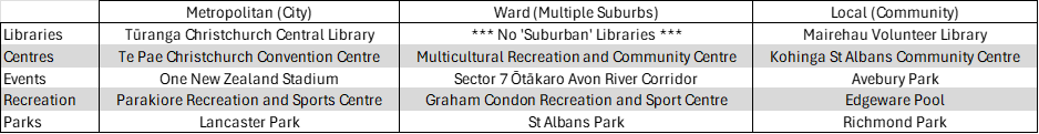
4. Building: What? 4.1. Community: Needs & Reach The table below highlights the different examples of Community Facilities available in the Innes & Central Wards, based on: – Metropolitan (City) – Ward (Multiple Suburbs) – Local (Community) The only ‘gap’ is in ‘Libraries’, no ‘Suburban’ libraries in the Innes or Central Ward.
Christchurch City Council | Community Facilities Innes & Central Wards | Community: Needs & Reach
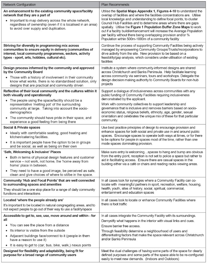
4.2. CCC Community Facilities Network Plan Christchurch City Council | Community Facilities Network Plan Trends toward hubs and focal points (Page 48 – 49): Worldwide trends tell us Community Facilities will be focal points in the community and will become known as neighbourhood and communal gathering places of flexible spaces that allow people to work/play/be/meet together in groups or work/play/be alone but connected to others outside of their homes. They will facilitate enquiry, self-reflection, social interaction, formal and informal activity. A trend is to hub significant facilities as part of community focal points.
Facility Activation – The Value Proposition (Page 56): It is important in the implementation phase of the CFNP to ask the question, “what will lead to the highest activation of the facilities?” By this we mean not just levels of us, ‘utilisation’, but also the mode and types of use to meet wider community needs for bumping space, for learning space and social spaces. The lowest form of activation is to make the facility ‘available’ to the community as a vessel-for-hire. The highest form is programmed space. The programmed facilities will have participants from a wider and more diverse cross-section of the population which typically includes those people who have access difficulties including but not limited to: – Those groups/individuals who find cost to participate a barrier – Those groups/individuals who find physical access a barrier – Those who have difficulties in social space, or issues with formalised situations – Time as a barrier (working or family care related) – Age, ethnicity, gender, sexual orientation as barriers Programmed space tailors activities to overcome barriers to participation including those listed above. In programmed space some users will have ‘free’ access while others may pay more for value added services. The beauty of this approach is that it still enables vessel-for-hire provision alongside programmed usage.
Facility Location Significance (Page 57): Some facilities are better suited to be hub locations based on their centrality within a neighbourhood/rural community, geographical location, accessibility and proximity to other hub or key locations such as libraries, social and community outdoor spaces, cafes, economic and commercial centres including malls and or proximity to aligned activity, school/education, church, sport and play related.
Ward and Neighbourhood Significance (Page 57): At the network level where there are potential hub facilities, the approach is to support their development as Council owned and operated site. Hub facilities are where there is co-location and clustering of services: library; service centre; community activity; recreation and sport; civic activity; culture, meeting and public assembly; education and arts activity.
Christchurch City Council | Community Facilities Network Plan Best Practice Community Facility Design
AI Overview: Best practice for community facility design in Christchurch emphasizes creating flexible, accessible, and durable “hubs” that foster social connection and resilience. Key principles include integrating with local, walkable transport networks, adopting sustainable and culturally reflective design (incorporating te reo me ona tikanga), and engaging with the community to ensure spaces meet local needs and encourage active participation. Key Design Principles & Best Practices: – Resilience & Safety: Post-earthquake standards are critical, with an emphasis on durable materials, seismic safety, and designing facilities that can serve as hubs during emergencies. – Flexibility & Multi-use: Spaces should be adaptable for diverse uses, including, but not limited to, community events, educational activities, and meetings to ensure high usage. – Accessibility & Inclusivity: Spaces must be welcoming and functional for people of all ages and abilities, reducing congestion with spacious layouts. – Co-location & Integration: Prioritize locating new facilities near schools, transport corridors, or other community hubs to improve accessibility and create vibrant activity centers. Focus on establishing “hubs” within neighborhoods that enhance, rather than replace, existing local infrastructure. – Community-Led Design: Engage stakeholders early in the process to ensure the design meets specific local needs and fosters a sense of ownership. – Sustainability & Environment: Integrate environmental considerations, such as sustainable building materials, energy efficiency, and low-impact designs. – Safety & Connection: Designing with good visibility, safe entryways, and connections to public open spaces encourages a sense of belonging and safety. – Local Identity: Facilities should reflect the character of their neighborhood and acknowledge local history. Specific Design Elements: – Outdoor Connections: Include spaces like sensory gardens, playgrounds, and recreational areas that link to surrounding green spaces. – Open, Airy Interiors: Use clear-span designs to allow for large, flexible, and well-lit spaces. – Street Engagement: Ensure public spaces “front” on to streets, encouraging safety and interaction. – Accessibility & Inclusion: Use clear signage and consider the needs of all ages and cultures, including children. – Safety: Prioritise good visibility to ensure safety. These practices align with the Council’s Urban Design principles to ensure that the city’s infrastructure and community facilities support active, connected, and resilient communities.
4.4. CCC Libraries 2025 Facilities Plan Christchurch City Council | Libraries 2025 Facilities Plan Role of library facilities in communities (Page 10): – Important, central meeting place and focal point in a community. – Open, spacious, welcoming environment; warm place to be in winter; vital social contact for many (especially older persons); place to meet (café) and relax with children and friends or family. – Outstanding location (e.g. overlooking ocean, park setting) – source of community pride, for the building and the resources available. – Access to a diverse range of reading materials – books, magazines, children’s and talking books; Central Library used by people for the value and depth of collection and there are more items from which to choose. – Free learning environment; provider of ‘second chance’ opportunities for adults wanting to learn. – Provider of general services, e.g. photocopiers, community/local information.
Location preferences (Page 10): – Near local shops/supermarket/mall/bank/medical centre/schools/playground/toy library; malls and aquatic facilities not seen as highly desirable areas for co-location or as adjacent locations; co-location with a Council service centre favoured. – On bus route/near transport hubs; handy walking distance from home; easily accessed, free, plentiful car parking adjacent to library. – Attractive street visibility.
Building requirements – needs and expectations (Page 10): – Spaciousness – cafes; room for quiet spaces away from bustle of café and children’s area; generous space between book stack aisles to enable easy browsing by less nimble and multiple users at one time; plenty of chairs/ beanbags and desks at which to work/relax. – Whanau-friendly facilities, e.g. children’s areas, baby feeding/changing facilities. – Outdoor environment important – need natural features and to be welcoming; clear signposting within and outside the building. – Accessible buildings and facilities for people with disabilities. – Small local libraries – easy to find way around. – Good infrastructure and building design (air conditioning, etc).
Christchurch City Council | Libraries 2025 Facilities Plan Based on ‘Location Preferences’ & ‘Building Requirements’
4.5. ReVision Youth Friendly Spaces Audits ReVision Youth Audit | 10 Shirley Road – The youth auditors really liked how the space is well connected within Shirley. 10 Shirley Road is right in the middle of other spaces local young people would access and is surrounded by bus stops connected to the central network. – The space has a variety of facilities for young people to use, such as the playground, basketball court, and a quiet space by the stream at the other end of the park. – They enjoy using the space as it is easily accessible and its activities give them something to do, while making them feel like they belong. – The areas young people thought could be improved on were the lack of basic amenities in the space and the underutilisation of the space. – One youth auditor mentioned that Shirley Primary, located across the road, uses the space sometimes, which makes it easier for kids to feel welcome to use the space. – Overall, it is a nice and safe park, with one auditor even commenting that it was enjoyable for all people, young or old, to use. – Another idea the auditors raised was to add an information board which includes youth-focused information and advertising. It should also include contacts to youth services and providers, in both Shirley and neighbouring areas. This will help young people feel comfortable with accessing support and could possibly introduce them to new groups and clubs. – In the long run, young people would like to see a youth centre or a place where young people can sit down and relax in a sheltered space which protects them from the elements. – During the day, they mentioned that the space feels safe due to its location on the main road and open areas. However, when dark, the auditors noted that they did not feel the same level of safety. – Another auditor mentioned that they would feel safe if more people were around. This could be achieved by adding more seating to attract more users and introducing more activities. – When asked if they felt ‘in the way’ when at the space, the auditors said that they did not and that they instead felt welcome by its other users; they felt that they were part of the community. – In terms of new activities, the auditors noted that the table tennis table is not fit for purpose as it is usually too windy to use. Instead, the auditors suggested that a big chess set could be developed, which would be something young people would welcome to the space. – Any space needs to be accessible, which includes disability access, physical movement to and around the space, and the affordability of engaging with the space. Young people commented that the space is easily accessible. – Due to its location on a main road, the space is easy for not just Shirley residents to access, but everyone in the city. – A traffic light installed right outside the main entrance makes it easier for young people to cross the road, while the bus stops located directly outside the space connect it to the city’s public transport network that many young people rely on. – With council already planning to build a new structure in the space, the youth auditors agreed that they would like this to be a building that would be a place to both run activities and relax.
ReVision Youth Audit | Shirley Library -The youth space was a key area the young people identified as needing change. Specifically, they wanted to see this space moved to a different area of the library. Young people don’t want to have a space that is at the back corner of the library. A young person suggested that they would change the layout to be more obvious where the youth space was and would make it larger. Another auditor really wanted to have a space that was at the heart of the library and was slightly removed at the same time. – Another common recommendation that young people felt would make the place livelier would be to add more plants and greenery. Not only would this create a ‘better vibe’ as one auditor said, but the young people felt that it would make the Shirley Library feel even more homely. – The suggestion of more chairs and comfy places to sit such as more bean bags etc. was also raised again within this discussion around resourcing. This highlights a strong consensus that the Shirley Library should have more places for both young people and all library users to sit. – The young people felt that there could be more toilets available for users in the library and also some gender neutral options that weren’t the disabled toilets. – When asked if the space reflected their culture many of the young people said that it doesn’t feel multicultural and that they would love to see more Te Ao Māori and Te Reo Māori around the space. – Young people wanted to feel included in decision making on clubs and activities for them and suggested providing different avenues for them to continue to do this. With this, they also wished to see a greater circulation of young adult books and the Shirley Library to be better resourced with activities and clubs for them. – A couple of young people highlighted how dark the mall and library car park were and this increased how unsafe they felt leaving the Library.
5. Design: How? ‘Shirley Community Facility’ Design Issues: 1. Building Placement: – Building located at the back of Reserve, not up front & connected to Shirley Road, hidden down the back. – Not centred on the Reserve, like the previous Community Centre, doesn’t line up with the path from Shirley Road. – Line of sight from Shirley Road to Dudley Creek, blocked by the south wall of the building. – CPTED (Crime Prevention Through Environmental Design) issues with the south wall of the building. 2. Dudley Creek: – Dudley Creek is the Reserve’s best asset. The building should be connected to the south of the Reserve. – There are no windows or doors on the south side of the building. This is the best view of the Dudley Creek area. 3. Dudley Character Design: – Gable or hip roofs that are consistent with adjacent residential buildings, like the former building. The roof pitch is not the same. – There is no Entry Porch/Front Door orientated to face Shirley Road. – Too many doors on the building facing Shirley Road/Chancellor Street, adds to the confusion of where is the Entry? – The side Entry door connected to the car park is convenient for those using that car park, but what about bus users & those who have parked on the other streets? – Floor to ceiling glass doors are not in keeping with the style of Front Doors on the surrounding residential buildings. – The new building does not have symmetrical large front windows facing the street, like the former building. 4. Interior/Exterior Design: – Will any of the items retrieved from the former Heritage Listed building be incorporated into this new building? – This is a Civic building, yet there is no Māori design principles (Te Aranga) incorporated into the new building? 5. Car Park: – The car park spaces have been reduced, which will affect Shirley Playcentre & Shirley Primary School. – The new car park is no longer connected to the path that goes from Slater Street to Chancellor Street. 6. Paths: – The former building was connected to all the current paths, plus it also had a path down the east side of the building, past the playground, Shirley Playcentre to South car park. – The new building is not connected to Shirley Road, the playground or Shirley Playcentre. 7. Toilets & Kitchen: – There are no windows for the toilets or kitchen. No natural light, so it will cost more for electricity & lights will need to be put on a sensor, so that they aren’t left on. – The kitchen & toilets will each need to be fitted with a ventilation system, as there are no windows to allow in fresh air. These will also need to be on a sensor, so that they aren’t left on.
5.1. Intergenerational AI Overview: Intergenerational design creates spaces, products, and communities that foster connection, empathy, and mutual benefit across different age groups. It merges universal accessibility with social architecture, aiming to combat loneliness and enhance social cohesion by designing environments that bring generations together. Key Principles and Elements: – Universal Design: Environments are accessible, safe, and usable for everyone, from children to seniors, often removing stairs and widening doorways. – Purposeful Interaction: Spaces, like community gardens or shared seating areas, are intentionally designed to encourage interaction and reduce age-related isolation. – Key Facilitators: Key elements for successful spaces include safety, comfort, easy accessibility for all ages, and fostering a sense of community. Benefits of Intergenerational Design: – Reduced Isolation: Helps tackle loneliness among seniors. – Community Enrichment: Enhances community cohesion through shared experiences and mutual support. – Social & Economic Value: Promotes lifelong learning, passes on skills between generations, and can offer more sustainable, durable, and cost-effective community infrastructure. – Positive Aging: Challenges negative stereotypes by treating aging as a gain in experience rather than a decline.
interGENdesign | Intergenerational Spaces Intergenerational spaces reside in both our homes and the public realm. These are shared communal areas that accommodate all ages and a wide range of activities. Children, youths, and older adults would be able to make connections with each other through scheduled programmes or spontaneous encounters. – Intergenerational Contact Zones (ICZS): An ICZ is defined as a spatial focal point for different generations to meet, interact, build relationships, and, if desired, work together to address issues of local concern. e.g. parks and community centres. – “For intergenerational dialogue to flow more readily, there must be an environment where generations can integrate seamlessly. There must be space conducive for engagements; design that integrates and not segregates different generations in the same space; and programmes and policies that aim at breaking institutional isolation in favour of dialogues across the generations.” Dr Leng Leng Thang, Assoc. Prof. of the Department of Japanese Studies (NUS)
Playcore | Implementation of Intergenerational Settings in Communities Our parks and public spaces have great potential to change our communities for the better. By bringing together people from all backgrounds and ages, the public places we all share can combat generational silos, segregation and other age-related issues we are facing as a nation, while helping to ensure equitable access for all. Intergenerational design aims to bring people together through purposeful, mutually beneficial activities that promote greater understanding and respect between generations. Additionally, investing in these spaces fosters value creation by building cohesive communities, encouraging additional investments in neighborhoods and local businesses, and changing the perception of safety. People of all ages have knowledge to share with other generations that may not be exposed to that knowledge. By creating opportunities for shared generations to spend time together, we open the door for intergenerational learning, and therefore understanding, compassion, and support for each other.
5.2. Universal Auckland Design Manual | Universal Design ‘Universal design’ means designing for inclusivity and independence. It caters for human diversity as well as life stages and scenarios, such as pregnancy, childhood, injury, disability and old age. How do we go about achieving outcomes such as social inclusion, health and wellbeing, and equity through design? There are eight practical goals that provide a framework for designing with universal needs in mind: 1. Body Fit, 2. Comfort, 3. Cultural Appropriateness, 4. Awareness, 5. Understanding, 6. Wellness, 7. Social Integration & 8. Personalisation. Includes: ’14 personas to keep in mind’ & ‘Universal design focus areas’.
Ministry of Business, Innovation and Employment (MBIE) | Practical Application of Universal Design A universal design perspective can help provide a better and more usable environment for everyone using a public building. Universal design of the built environment starts with four overarching aims: 1. Everyone should be included, irrespective of their individual capability, knowledge, skill level, race, religion, gender, age or size. 2. Everywhere should be physically accessible – to everyone and achievable in an easy, safe, independent and convenient way. 3. Everything should be equally accessible, understandable and usable by everyone everywhere. 4. Every solution should seek to accommodate the needs of everyone, while not excluding or segregating anybody.
Ministry of Business, Innovation and Employment (MBIE) | Buildings for Everyone: Designing for Access and Usability Providing a better and more usable environment for everyone is a fundamental tenet of good design. To address the needs of everyone using public buildings, this guide has been developed from a universal design perspective. Universal design is about approaching design of the built environment with the knowledge that a wide range of people with different physical, sensory and cognitive capabilities will be using a building. The guide offers valuable insights into the user journey for people with a wide range of physical, sensory and cognitive capabilities and provides information on practical approaches to the design, construction and management of public buildings to meet building user needs. The guide consists of 11 sections: 1. Building user activity 2. Surrounding area and transport 3. Pedestrian circulation 4. Vehicle circulation and parking 5. Building entrances and exits 6. Internal circulation 7. Interior space 8. Fixtures and fittings 9. Building types 10. Means of escape 11. Building management The first section on building user activity looks at the three common activity processes that all building users go through – gather information, process that information and take action. In each of the ten following sections a commentary is included to provide a better understanding of the needs of various building users and how design decisions can affect them.
5.3. Sensory Friendly AI Overview: Sensory Friendly Design in New Zealand public spaces focuses on reducing sensory overload for neurodiverse individuals through quiet zones, natural lighting, muted colors, and calming, tactile elements. Key features include acoustic treatments, intuitive wayfinding, and sensory-friendly, inclusive, and accessible spaces. Key Elements of Sensory-Friendly Public Spaces in NZ: – Acoustics & Quiet Zones: Incorporation of sound-absorbing materials to reduce echoing, particularly in libraries and community hubs. – Lighting: Preference for natural light, with indirect, dimmable, and flicker-free lighting to minimize glare and visual stress. – Visual Environment: Use of neutral, muted color palettes in flooring and walls rather than bright, stimulating colors. – Nature-Based Design: Integrating sensory gardens with varied textures (plants, wood, sand) to provide calming, natural sensory input. – Spatial Layout: Providing clear, intuitive, and consistent signage and layouts, including designated “quiet spaces” or “calm zones” in high-traffic areas. – Amenities: Using paper towels instead of noisy hand dryers in bathrooms and creating accessible, flexible, and sensory-friendly spaces. These design principles aim to create inclusive environments that are enjoyable for all, minimizing potential triggers that can lead to fatigue or sensory overload.
Guggenheim New York | Creating a Sensory-Friendly Environment Sensory-friendly spaces build on universal design by making the environment accessible from a sensory standpoint. Sensory-friendly environments engineer sensory stimuli in a way that empowers neurodivergent visitors to fully participate, engage with the physical space, and optimize their visit. Best of all, sensory-friendly design is appreciated by all visitors. Just as curb cuts on street corners empower people using wheelchairs, they also help people with strollers, rolling luggage, and so on. We all benefit from physical spaces that are welcoming and comfortable. How to Create a Sensory-Friendly Environment: Our physical environment has a strong impact on all of us, especially on those with significant sensory sensitivities. Fortunately, there are practical strategies that can reduce or even eliminate noxious sensory experiences. – Lighting: People with sensory differences tend to be highly sensitive to artificial light and glare. Use diffused natural light whenever possible. When using artificial light, warm LED bulbs, halogen, and old-fashioned incandescent bulbs are often best tolerated. Dimmer switches provide ideal flexibility for all lighting. – Sound: Because many people are hypersensitive to overall noise or particular frequencies of sound…Reduce ambient noise as much as possible. There are many solutions available: hanging acoustic tiles, room dividers, rolling panels, and flooring materials. Tiles, dividers, and paneling also function to reduce the glare and heat from sunlight streaming in through windows. Become a Sensory Detective! As you consider your specific public space, think of yourself as a sensory detective using a magnifying glass to track down potential problems. – Examine the entrance: What do visitors experience when they enter your doors? As visitors enter your space, remember that they bring with them all of the challenges of preparation for and transportation…they may arrive already feeling overwhelmed. This makes a calm entrance especially important. The entrance is a space of transition: it offers a way to break from whatever experiences came before and to set the tone for the experiences to come. – Consider path of travel: How do visitors navigate your space? How do they get from one place to another, and how do they know where to go? As you hunt for the sensory challenges in your space, keep in mind that some visitors have difficulty navigating unfamiliar spaces and following multistep verbal directions. – Create Sensory Havens | Quiet Areas and Activity Areas: Do you have spaces that allow visitors to step away from the sensory stimulation of the environment? Do you have ways for visitors to engage in sensory stimulation that is not permitted in other spaces? Remember that not all people with sensory differences need a quiet, sensory-reduced refuge. Sensory seekers may benefit from a space in which they are free to move and touch things. – Examine the restrooms: The restroom is a place that is often overlooked, but can be a difficult space for people with sensory sensitivities. Automatic jet air hand dryers emit a high frequency sound many people find distressing or intolerable.
Advanced Therapy Clinic | Crafting Inclusive Spaces for Sensory Sensitivities What is a sensory-friendly environment and why is it important? A sensory-friendly environment is a space specifically designed to reduce overwhelming sensory input, making it more comfortable for individuals with sensory processing challenges, such as those with autism, anxiety, ADHD, or PTSD. This type of environment considers all eight senses – sight, hearing, taste, touch, smell, movement, balance, and proprioception – ensuring that sensory preferences can vary among individuals. Practical strategies for creating these environments can significantly enhance the overall experience for everyone involved. Here are some effective adjustments: – Lighting Adjustments: Use dimmable lights or natural light to create a calming ambiance, avoiding harsh fluorescent lights that may flicker and overwhelm. – Noise Management: Minimize background noise through the use of sound-absorbing materials or noise-canceling headphones. – Quiet Areas: Designate sensory spaces with comfortable seating and soothing items for relaxation and retreat from sensory overload. – Calm Color Schemes: Choose soothing colors like soft blues and greens for walls to promote relaxation, avoiding overly stimulating colors. – Visual Clarity: De-clutter spaces with organized signage and streamlined displays to prevent visual overwhelm. Sensory-friendly environments are essential for improving accessibility and quality of life, allowing individuals with sensory sensitivities to participate in activities alongside their peers comfortably.
5.4. Culture AI Overview: Cultural design integrates specific cultural values, narratives, and traditions into the design process to create meaningful environments, products, and experiences. It involves engaging directly with communities to reflect their identity – such as using Māori design principles (Te Aranga) in architecture – ensuring spaces tell local stories. – Cultural Architecture & Spaces: Involves embedding narratives into physical structures, such as using wharenui (meeting house) elements to represent ancestors, as seen in library and public space designs. – Spatial Layout: Organizing spaces around themes of community, gathering, and welcome, often mirroring the layout of a marae (meeting grounds). – Narrative Façades and Ornamentation: Using traditional carving (whakairo), weaving patterns (raranga), and modern materials to tell local stories and histories of the area. – Materiality: Using natural materials like timber, stone, and earth, often sourced locally, to ground the building in the land.
Auckland Design Manual | Universal Design | Cultural Appropriateness Aotearoa-New Zealand is a bi-cultural nation with a unique history and heritage. It is important to reflect Te Ao Māori in our built environment. This can be expressed through design, language, signage, and providing spaces and places that enable cultural protocols to occur. Being able to clearly see our tangible and lived culture in the built environment helps to foster a sense of place, and can help to normalises the use of both of our national languages in everyday life.
Te Whare Tapa Whā | Wellbeing Model Te Whare Tapa Whā was developed by leading Māori health advocate Sir Mason Durie in 1984. The model describes health and wellbeing (hauora) as a wharenui/meeting house with four walls. These walls represent: – taha wairua/spiritual wellbeing, – taha hinengaro/mental and emotional wellbeing, – taha tinana/physical wellbeing & – taha whānau/family and social wellbeing. Our connection with the whenua/land forms the foundation. When all these things are in balance, we thrive. When one or more of these is out of balance our wellbeing is impacted.
Christchurch City Council | Libraries 2025 Facilities Plan (Page 6) The value of public buildings such as libraries is emphasised in the Urban Design Protocol (which Christchurch City Council is a signatory to): they protect the cultural identity and heritage of our towns and cities; provide creativity; and add social, environmental and cultural benefits by creating well connected, inclusive and accessible places.
Ministry for the Environment | Urban Design Protocol (2005) The New Zealand Urban Design Protocol (Urban Design Protocol) is part of the Government’s Sustainable Development Programme of Action. The Urban Design Protocol is a key deliverable of the ‘Sustainable Cities’ action area, which seeks to make our cities healthy, safe and attractive places where business, social and cultural life can flourish. It supports and builds on a range of government strategies for improving our urban environments that encompass economic growth and innovation, transport, housing, regional development, social development, health, disability, and culture and heritage.
5.5. Heritage AI Overview: Heritage design focuses on preserving historical character while integrating modern comfort, often utilizing traditional materials like timber, masonry, and stone for lasting quality. In New Zealand, this style is popular for creating homes with character, blending original features like arches with contemporary, functional layouts. Key Elements of Heritage Design: – Modern Heritage Aesthetics: Combines the historical “soul” of a home at the front with modern, open-plan living and sensorial richness at the rear. – Materials & Textures: Emphasizes lasting materials such as timber panels, marble, and tile. – Color Palette: Features grounded, rich tones like ginger reds, navy, and muted blues. – ‘New Heritage’ Styling: Focuses on curated simplicity—mixing vintage finds with modern elements to create a lived-in look. – Regional Trends: In Canterbury, developers often build new homes that emulate classic villas and bungalows to blend with existing character.
5.6. Biophilic Wikipedia | Biophilic Design Biophilic design is a concept used within the building industry to increase occupant connectivity to the natural environment through the use of direct nature, indirect nature, and space and place conditions…it is argued that this idea has health, environmental, and economic benefits for building occupants and urban environments. Indirect experience refers to contact with images and or representations of nature. The experience of space and place uses spatial relationships to enhance well-being.
AI Overview: Biophilic design is an architectural and interior design approach that enhances human well-being, health, and productivity by deliberately connecting occupants with nature. It incorporates natural materials, light, vegetation, and organic forms into the built environment to reduce stress, improve cognitive function, and foster a stronger bond with the natural world. Key Principles and Elements: – Direct Nature in Space: Using actual natural elements like houseplants, green walls, water features, natural lighting, and airflow. – Indirect Nature (Analogs): Using materials, colors, and shapes that mimic nature, such as natural wood, stone, earthy tones, and fractal patterns. – Space and Place Conditions: Designing spaces that mimic spatial configurations found in nature, such as views of the horizon, sensory-rich spaces, or areas that offer a sense of refuge and prospect. Benefits of Biophilic Design: – Health and Well-being: Reduced stress levels, lowered blood pressure, and faster healing rates. – Productivity and Creativity: Improved cognitive performance and increased creativity in workplaces. – Environmental Impact: Enhanced air quality, improved biodiversity, and improved energy efficiency. Common Applications: – Public Spaces: Utilizing green walls, indoor water features, and natural views.
5.7. Environmental Wikipedia | Environmental Design Environmental design is the process of addressing surrounding environmental parameters when devising plans, programs, policies, buildings, or products. It seeks to create spaces that will enhance the natural, social, cultural and physical environment of particular areas. Environmental design can also refer to the applied arts and sciences dealing with creating the human-designed environment. Core Principles: 1. Sustainability: Minimizing the environmental impact of human activities through the use of renewable resources, energy-efficient technologies, and eco-friendly materials. 2. Functionality: Designing spaces that are practical, accessible, and tailored to the needs and behaviors of the people who will use them. 3. Aesthetics: Incorporating elements of visual appeal, sensory experience, and emotional connection into the design. 4. Holistic Approach: Considering the interconnected social, economic, and ecological factors that shape the environment. Key areas of focus include: – Sustainable architecture and green building – Landscape architecture and urban planning – Transportation design and infrastructure – Industrial design and product development – Interior design and space planning Environmental designers often collaborate with experts from disciplines such as engineering, ecology, sociology, and public policy to create holistic solutions that address the complex challenges of modern environments.
5.8. Sustainable AI Overview: Sustainable design is a holistic approach to creating products, buildings, and systems that minimize environmental impact, reduce waste, and improve occupant health through energy efficiency, sustainable materials, and long-term durability. Key strategies include using passive solar design, high-performance insulation, and renewable materials to lower energy and water consumption. Key Sustainable Design Principles: – Energy Efficiency: Utilizing insulation, double glazing, and smart design to minimize heating/cooling needs. – Material Selection: Choosing sustainable, recycled, or bio-based materials (e.g., Mycelium leather or citrus-waste plastics). – The 6 Rs: Adopting a framework of Reduce, Reuse, Recycle, Rethink, Refuse, and Repair. – Longevity & Flexibility: Designing spaces and products for long life, adaptability, and eventual disassembly.
5.9. Crime Prevention Through Environmental Design (CPTED) Christchurch City Council | Safer Canterbury: Creating Safer Communities How can environmental design help prevent crime? Careful environmental design can help to prevent crimes like personal assault and vandalism. The major principle of Crime Prevention Through Environmental Design is: Natural surveillance – “see and be seen” People are usually less likely to commit crime if they are (or think they may be) being watched. Conversely people are likely to feel safer if they think someone is ‘looking out for them.’ 1. Designing buildings to overlook streets and public spaces. 2. Ensuring that there are clear sight lines along routes by: – Avoiding sudden corners or blind bends along pedestrian or cyclist routes. – Ensuring that planting does not grow to obscure the view or provide hiding places for offenders. – Avoid dark recesses or concealed corners adjacent to pedestrian routes if possible. 3. Providing good standards of lighting by: – Choosing lighting that illuminates pedestrian areas as well as roads. – Providing consistently placed, high quality lighting which will not conflict with planting or create large areas of shadow. 4. Ensuring that there is plenty of activity by: – Designing pedestrian/cycling routes to ensure that they will be well used to prevent them becoming isolated and unsafe. – Designing pedestrian routes so that they run alongside vehicular routes and are highly visible. – Locating and designing parks so that they are overlooked by roads and houses. – Encouraging a mix of uses so that space is used throughout the day and the evening. How can we make our Parks, Reserves and Waterways feel safer? The safety of parks, reserves and waterways will be affected by: – Their location and layout – Their relationship with surrounding activities – The activities contained within them – The design and location of landscaping and structures within them. 1. General Good planning and design contributes to increased usage, a good relationship between public and private spaces and maximised informal surveillance. This can be achieved by: – Locating parks so that they can be easily seen from surrounding houses and streets. – Locating high use elements, such as toilets, playgrounds, and main paths, so that they are visible from adjoining streets, houses, and from within the park. – Providing facilities for activities which attract people into parks and reserves, and encourage them to stay longer. 2. Pathways Pedestrian access ways can enhance the function of public open spaces, but they need to be carefully designed and located. Pathways can be made to feel safer by: – Ensuring the provision of adequate sight lines along the route. – Avoiding areas of potential entrapment or concealment along the pathway. – Directing people through safe areas with good signage and lighting. – Providing at least one safe route through parks, with frequent ‘escape routes’ back to surrounding streets and car park areas. 3. Lighting Use of parks at night should be discouraged and only paths that are essential designated routes should be lit. However lighting alone will not make parks or a route safer. Lighting should be carefully considered and combined with other safety design measures. 4. Planting and Maintenance Planting and fencing provide an amenity and safety function, but care should be taken to ensure they do not block views, or create ‘hiding places’ and entrapment spots. A neglected space is likely to invite anti-social behaviour and will feel unsafe. Particular care should be taken when considering the area around toilet facilities. 5. Seating Careful choice and location of seating can help to make public open spaces more popular and increase safety. This can be achieved by: – Placing seating in locations which are visible from the park or surrounding streets. – Locating seats so that they face the pathway as a path going along the back of a seat may make a person who sits there feel uncomfortable or unsafe. – Planning seating layouts to encourage social interaction and casual surveillance. 6. Signs Signs can help to make people feel safter in a park or reserve by: – Providing well place direction information signs. – Using symbols, maps and diagrams to assist users. – Designing signs to be clear for people with disabilities and speakers of other languages. – Using signs which indicate routes so users know their destination.
1. 10 Shirley Road | Advocacy 1.1. ‘Gateway to the East’ (2018) 1.2. ‘You Are Here’: ‘A Place To Be’ 1.3. ‘Shirley Centre’ Concept 1.4. ‘Shirley Centre’: Community Needs 1.5. ‘Shirley Centre’: Visitor Experience 1.6. Third Places & Bumping Spaces 1.7. Christchurch East Libraries 2. ‘Shirley Centre’ | Community Centre 2.1. Community Hub: Building Connections 2.2. Learning Library with Learning Spaces 2.3. Christchurch City Council Service Centre 2.4. Civil Defence & Voting Centre 2.5. Early Childhood & Youth Centre 2.6. Support Services Centre 2.7. Multicultural Centre 2.8. Local History Centre 2.9. Family History Centre 2.10. Visitor Information Centre 3. Shirley Community Reserve | Location 3.1. 10 Shirley Road: Placemaking 3.2. ‘Shirley Centre’ on Shirley Road: Information Centre 3.3. Community (Horizontal Roads) 3.4. Commercial (Vertical Roads) 3.5. Shirley Road to New Brighton Road (Scenic Route) 3.6. Transport Options 4. Ōtākaro Avon River Corridor | Activities 4.1. Ōtākaro Avon River Corridor City to Sea Pathway 4.2. Sutton Heritage House and Garden 4.3. Avebury House, Richmond Community Garden & Riverlution 4.4. Climate Action Campus 4.5. Sector 7 Events 4.6. Ōtākaro Avon River Corridor: Footbridges & Landings 4.7. Kerrs Reach Flatwater Sports Hub 5. Ōtākaro Avon River Corridor | Ideas by Joanna Gould (2018) 5.1. Red Zones Future: Ideas Map 5.2. Sutton’s Place | Idea (2018) 5.3. River Road Park | Idea (2018) 5.4. River Bank Centre | Idea (2018) 5.5. Retreat Road Park | Idea (2018) 5.6. Draft OARC Regeneration Plan: ‘Tell Our Stories’ 5.7. Draft OARC Regeneration Plan: Visitor Experience 5.8. Draft OARC Regeneration Plan: Community Needs
1. 10 Shirley Road | Advocacy 1.1. ‘Gateway to the East’ (2018) https://www.youtube.com/watch?v=w-8LmUPeGcg Verbal Submission for the Christchurch City Council Long Term Plan in 2018: – Former Christchurch Mayor Lianne Dalziel: “I really liked your submission, largely because of the imagery around the history of the site & what’s planned for the future. https://www.10shirleyroad.org.nz/building-ideas/ Are you saying, rather than just building back a Community Centre, that actually we should look at the whole of the area & look at the whole of the needs. Maybe what we need to be considering for the Long Term Plan, is a budget that would enable a full needs analysis & to look at what the different options are. There is a Facebook page that’s been setup that suggests moving the Library & other things…” – Joanna Gould: “Yes, my research was that. I created 10shirleyroad.org.nz. When I had the idea, I was standing across the road from Shirley Primary School with Ben [my son]. I just thought “what if”, what if we could dream big & create this whole block as a destination space, that invites everybody. It’s a meeting place, it’s a community centre, but we also have so many nations settling in our area. I wanted to welcome them into this area & make them feel part of this area. I see the whole space alive with people, all sorts of people, young or old, disabled or whatever, they can still access this space, they can come in. It can be put back as a destination space, a learning space for the whole community, for Christchurch & to get the tourists involved in it as well, because it is the ‘Gateway to the East’.”
1.2. ‘You Are Here’: ‘A Place To Be’ https://www.10shirleyroad.org.nz/you-are-here-a-place-to-be/ On a map, the ‘You Are Here’ icon is a reminder of your location. ‘You Are Here’ locators are usually to help tourists or those new to an area, find their bearings again & see which way they need to go. ‘You Are Here’ in these communities surrounding 10 Shirley Road: Shirley, Dallington, Richmond, Edgeware, St Albans & Mairehau. Whether you have just arrived in this country, recently moved into these communities, here temporarily (renting) or permanently (bought a house), while ‘You Are Here’ welcome to the Shirley Centre, ‘A Place To Be’, within our local communities.
1.3. ‘Shirley Centre’ Concept https://www.10shirleyroad.org.nz/shirley-centre-concept-image/ ‘Shirley Centre’: Identity | Well-being | Learning – New ‘Contemporary’ Community Centre/Citizen Hub. – Relocate the current Shirley Library from The Palms car park. – New Library with Learning Spaces & Meeting Rooms. – New Inclusive Accessible Playground & Shirley Playcentre. – Community Education & Support Services in ‘Learning Libraries’.
1.4. ‘Shirley Centre’: Community Needs ‘Learning Libraries’: https://www.10shirleyroad.org.nz/learning-libraries-concept/ What happens inside the library has more impact on our communities. How? By creating Learning Libraries: citizen hubs where Community Education is at the centre & the Learning Spaces are utilised by the Government, Christchurch City Council & other Organisations, as an outreach to the residents in the surrounding communities. Learning Libraries are ‘schools in the community for everyone, all ages & stages of life are welcome.’
1.5. ‘Shirley Centre’: Visitor Experience – AI Overview | Key Benefits of Libraries for Visitors: Libraries are essential for visitors, acting as vital community hubs that provide public toilets, free Wi-Fi, travel resources, and quiet, accessible spaces to relax, work, or explore local culture. They serve as trusted information centers, offering maps, local guides, and expert knowledge from staff to enhance the visitor experience. – Free Technology & Connectivity: Libraries provide free, reliable Wi-Fi, public computers, and printers, essential for travelers managing tickets, exploring digital resources, or working remotely. – Information & Local Knowledge: They offer access to tourist brochures, local maps, and detailed guides. Librarians often act as local guides, offering insider tips on regional history, culture, and attractions. – A ‘Third Place’ Refuge: Libraries provide a quiet, free, and comfortable refuge from busy city streets or limited hotel space, offering a relaxing environment and, in some cases, air conditioning or heating. – Cultural Immersion: Many libraries showcase local art, host local history exhibitions, or offer programs that allow visitors to deeply engage with the community’s heritage. – Architectural Landmarks: Many libraries, have become attractions themselves, drawing travelers with unique, world-class design and architecture. – Inclusive Spaces: Libraries offer welcoming spaces for everyone, providing, for instance, sensory-sensitive areas for neurodivergent visitors. – For visitors looking to connect with a community authentically, libraries provide a unique, free, and valuable resource.
1.6. Third Places & Bumping Spaces https://www.10shirleyroad.org.nz/third-place/ Libraries are ‘third places (social)’ the ‘living room’ of society in our communities. We have many in our communities who don’t have a ‘second place (work)’: stay at home parents, caregivers, retirees, unemployed, people working from home etc. Some due to their circumstances don’t feel like they have a safe and relaxing ‘first place (home)’. This is why it is so important that our ‘third places (social)’ are welcoming and inclusive for everyone in our communities. https://www.10shirleyroad.org.nz/bumping-spaces/ “Bumping Spaces are places in the community where we naturally bump into each other, they are our communal spaces, gathering places. A trusted environment where we spend time together, share space together… Community is built on relationships and people develop relationships through frequent contact with others. So, if you want to build community, you need places to bump into other people. The closer those places are to where you live, the more likely you are to bump into the same people over and over again… If you want to develop an inclusive community, you need to have inclusive bumping spaces.”
1.7. Christchurch East Libraries – Waitai Coastal-Burwood-Linwood Community Board (5 suburban libraries) https://www.10shirleyroad.org.nz/christchurch-city-libraries-by-community-board/ Coastal Ward: Parklands Library & New Brighton Library Burwood Ward: Shirley Library & Aranui Library Linwood Ward: Linwood Library – Shirley Library | The Palms Mall https://www.10shirleyroad.org.nz/shirley-libraries/ The current/2nd Shirley Library is located in a ‘Commercial Zone’ car park with no outdoor space or learning spaces & no toilets available in the Library area. These other East Libraries (Aranui, Parklands & New Brighton) are standalone buildings with their own identity, clearly visible from the street, easy to give location directions to visitors, ‘destination spaces’ in their communities, with outdoor spaces surrounding their buildings.
2. ‘Shirley Centre’ | Community Centre https://www.10shirleyroad.org.nz/shirley-centre-community-overview-map/ 2.1. Community Hub: Building Connections Promoting awareness of the existing Community Facilities, Recreational Spaces & Local Green Spaces to residents & visitors to the area. 2.2. Learning Library with Learning Spaces Providing opportunities for Community Education through book collections, activities & events in the new multipurpose Learning Spaces. 2.3. Christchurch City Council Service Centre Co-located Council Services with the new Shirley Library & Customer Service Hub. 2.4. Civil Defence & Voting Centre Central accessible location for a new Civil Defence Centre for emergencies (to provide safety, information & assistance) & Voting Booth location for elections. 2.5. Early Childhood & Youth Centre Creating connections from babies to preschoolers, through the new inclusive accessible playground, Shirley Playcentre (located on the Reserve) & Shirley Library: Wā Pēpi-Babytimes & Wā Kōrero-Storytimes. Centrally located for Youth, between Mairehau High School & Shirley Intermediate School, bus stops both sides of Shirley Road (transfer point between The Oribter & East bus routes) & Half Basketball Court/Youth Space (free WiFi & outdoor seating). 2.6. Support Services Centre Promoting & connecting residents with local Support Services available in our communities like The Loft, Citizen Advice Bureau, Crisis Recovery Café, Human Library Organization etc. Through our new Learning Spaces, providing outreach opportunities for Support Services in a centrally located familiar safe space. 2.7. Multicultural Centre Acknowledge New Zealand’s bicultural foundation based on the Treaty of Waitangi (te Tiriti o Waitangi) between Māori and the British Crown. Supporting multiculturalism by offering resources in various languages, plus outreach programs & technology services to support new residents & visitors. 2.8. Local History Centre ‘Tell Our Stories’ to locals & visitors to our area by sharing information & resources that document our heritage, culture & the development of our communities around Shirley Road. 2.9. Family History Centre The NZ Society of Genealogists – Canterbury Branch were located in the former Shirley Community Centre for 21 years from February 1990 until the February 2011 earthquakes. Now Canterbury Genealogy, located in the Parkview Community Lounge, 75 Queenspark Drive, Parklands. DNA & Genealogy drop-in sessions at current Shirley Library on the first and third Saturdays of each month. 2.10. Visitor Information Centre ‘First Impressions Count’, what will our visitors to this area see? 10 Shirley Road is the first stop for visitors as they enter Shirley Road/‘Gateway to the East’, before traveling along New Brighton Road, beside the Ōtākaro Avon River to New Brighton. Providing local information, activities, events, bus routes/timetables, map of the Ōtākaro Avon River Corridor.
3. Shirley Community Reserve | Location 3.1. 10 Shirley Road: Placemaking https://www.10shirleyroad.org.nz/placemaking/ “The Power of 10+ is a concept Project for Public Spaces developed to evaluate and facilitate Placemaking…The idea behind this concept is that places thrive when users have a range of reasons (10+) to be there. These might include a place to sit, playgrounds to enjoy…history to experience, and people to meet. Ideally, some of these activities will be unique to that particular place, reflecting the culture and history of the surrounding community.” https://www.pps.org/article/the-power-of-10 1. ‘Suburban’ Library 2. Christchurch City Council Service Centre 3. Learning Spaces 4. Meeting Rooms 5. NZ/Genealogy Area 6. Internal Courtyard 7. Indoor/Outdoor Seating Options 8. Natives Garden (Dudley Creek) 9. Wellbeing Sensory Garden 10. Events/Market Space (Carpark) 11. Inclusive Accessible Playground 12. Basketball Court/Youth Area 13. Shirley Playcentre 14. StoryWalk 15. Dudley Creek Trail
3.2. ‘Shirley Centre’ on Shirley Road: Information Centre Information Centre: “a place where members of the public can get information about an area, organization, activity, etc.” – Māori Settlements & Early Settlers History – Area History: Pre Earthquakes – Area History: Post Earthquakes – Architecture: George Penlington, Chancellor Street Heritage Houses & Dudley Character Area – Engineering: Dudley Creek Flood Remediation – Landscape Architecture: George Brington Malcolm & Emmett Street Trees – Residential Red/Green Zone: ‘Tell Our Stories’ – Ōtākaro Avon River Corridor: Landings & Bridges – Ōtākaro Avon River Corridor: Activities & Events
3.3. Community (Horizontal Roads) From Edgeware Road to Shirley Road, Community Facilities include: Rehua Marae, Kohinga St Albans Community Centre, Edgeware Pool, Shirley Community Reserve, Te Oraka Community Pool (Shirley Intermediate) & Avon Hub (Recreation Centre). With MacFarlane Park Centres to the North & Avebury House to the South.
3.4. Commercial (Vertical Roads) – Stanmore Road | From Avonside Drive to North Avon Road Regenerate Christchurch have suggested as part of the Ōtākaro Loop Reach ‘Christchurch on a Plate’…Heritage NZ describes the Richmond area “as a food resource for Maori and Pakeha settlers.” https://lifeisajourney.co.nz/rur/kai-town/ ‘Idea to make Stanmore Rd an international smorgasbord’ (2018) https://lifeisajourney.co.nz/rur/idea-to-make-stanmore-rd-an-international-smorgasbord/ – Marshland Road | From Shirley Road to Prestons Road Approx. 5km of Commercial/Retail along Marshland Road includes: The Palms Mall, 42 – 50 Marshland Road (New Development), Shops/Restaurants (between Joy & Pagoda Streets), Homebase (Existing), Homebase (New Development), Homebase (Future Development), Orchards, Fruit & Veges Markets, Shops/Restaurants (Cnr Marshland & Prestons Road).
3.5. Shirley Road to New Brighton Road (Scenic Route) – Shirley Road to New Brighton Road | ‘Gateway to the East’ 10 Shirley Road is a very visible historic location at the beginning of Shirley Road, which then becomes New Brighton Road, a scenic road to travel by bus or car through the Residential Red/Green Zones, following the Ōtākaro Avon River to New Brighton. “The first route from Christchurch to New Brighton in European times was via Fitzgerald Avenue (then the East Belt), and Shirley and New Brighton Road. Because it was the first route, it was sometimes called the ‘Old Brighton Road’. New Brighton Road dates from 1860s.” https://my.christchurchcitylibraries.com/blogs/post/how-to-get-to-new-brighton/ – Shirley Road to New Brighton Road | Residential Red Zone, Christchurch “Welcome to the Residential Red Zone. This zone encompasses areas around Bexley Wetland, Brooklands, South Brighton, Southshore, the Port Hills and the Ōtākaro River Corridor including Richmond, Dallington, Avonside and Brooker Ave.” https://ccc.govt.nz/parks-and-gardens/explore-parks/residential-red-zone – Shirley Road to New Brighton Road | History & Post Earthquakes https://www.10shirleyroad.org.nz/historic-landmark/ https://www.10shirleyroad.org.nz/the-christchurch-districts-of-windsor-and-shirley/ 1st: Shirley | Shirley Community Reserve, former Shirley School/Shirley Community Centre site, building demolished after the earthquakes in 2012. 2nd: Dudley Creek (located at the back of the Reserve), part of the Dudley Creek Flood Remediation, along Stapletons Road, Petrie Street to Medway Street. Through wayfinding signage, share the technical behind-the-scenes information and lessons learnt, with visitors to these sites. https://lifeisajourney.co.nz/rur/dudley-creek/ 3rd: Chancellor Street Heritage Houses (Workers Dwelling Act & Social Housing Heritage) in Dudley Character Area, Richmond. 4th: Housing Intensification from Bungalow & Villa homes to Townhouses. 5th: The Palms Mall 6th: Burwood Park 7th: Residential Red Zone/Green Zone (Dallington, Horseshoe Lake, Burwood, New Brighton) with Landings & Footbridges. https://www.10shirleyroad.org.nz/shirley-centre-post-earthquakes-map/ 8th: New Brighton | “Eastern Christchurch’s main entertainment and tourist centres” includes: New Brighton Beach, New Brighton Pier, He Puna Taimoana Hot Pools, New Brighton Seaside Playground, New Brighton Mall/Shopping Centre, New Brighton Village Green, New Brighton Museum & New Brighton Library. – Shirley Road to New Brighton Road | Public Transport https://www.ecan.govt.nz/get-involved/news-and-events/2025/route-7-frequency-increase-causing-increase-in-patronage-too “In April the route switched to running every 10 minutes from 5.30am to 6.30pm on weekdays and every 15 minutes outside of those hours, and on weekends.” https://www.rnz.co.nz/news/national/588286/country-s-lightest-electric-double-decker-bus-to-hit-christchurch-s-roads-next-week “The [electric double-decker] bus was intended to start on the Route 7 Halswell-Queenspark service and would be tested on several of Metro’s busier routes.” “The bus can take up to 95 customers including 14 standing downstairs.” https://www.metroinfo.co.nz/news/metro-welcomes-its-first-electric-double-decker-bus-the-lightest-in-the-country/
4.2. Sutton Heritage House and Garden http://www.suttonhouseandgarden.org.nz/ “…the house, including a studio, built in 1962 for the renowned Canterbury artist and educator William Alexander Sutton, (1917 – 2000) – usually known as Bill Sutton – at 20 Templar Street, Richmond. He lived there for thirty eight years. Most of his celebrated work created during this period – both landscapes and portraiture – was painted here. Sutton’s house was designed by Tom Taylor, (1925 – 1995), a friend and teaching colleague and a sculptor who had studied architecture for two years; it is the only remaining Tom Taylor designed house in Christchurch which has retained its original design. The luxuriant garden around the house was designed and planted by Bill Sutton himself.” “Graham Densem – (B.A., Dip.L.A.) Retired Landscape Architect and former Senior Lecturer in Landscape Architecture at Lincoln University. Graham’s experience with Sutton House began in the 1990’s when Bill Sutton graciously allowed student visits to his most characterful garden. His mission is to see the heritage garden maintained as its creator intended, and the surrounding park developed as a community facility honouring Bill Sutton.” http://www.suttonhouseandgarden.org.nz/our-trustees/
4.5. Sector 7 Events https://ccc.govt.nz/parks-and-gardens/regenerationareas/otakaro-avon-river-corridor/sector-7-events “Sector 7 is an event space in the Ōtākaro Avon River Corridor (OARC), between Locksley Avenue and New Brighton Road. Events for approximately 5000 people can be held in this space. Public parking is not available on-site, so attendees are encouraged to plan to use alternative transport to the site.”
4.6. Ōtākaro Avon River Corridor: Footbridges & Landings https://www.10shirleyroad.org.nz/shirley-centre-post-earthquakes-map/ (see Layer: ‘3. Shirley Centre | Information Centre’) Medway Footbridge, Dallington Bridge, Snell Place Footbridge, Avondale Footbridge, Dallington Landing & Wainoni Landing.
5. Ōtākaro Avon River Corridor | Ideas by Joanna Gould (2018) 5.1. Red Zones Future: Ideas Map https://lifeisajourney.co.nz/rur/red-zones-future-ideas-map-by-joanna-gould/ My ideas for Richmond/Avonside and the Red Zone Futures: Ōtākaro Avon River Corridor, include: Shirley Community Centre, Dudley Creek, Kai Town, Street Art, Sutton’s Place, River Road Park, River Bank Centre, Retreat Road Park, Kerrs Reach & Woodham Park.
5.2. Sutton’s Place | Idea (2018) https://lifeisajourney.co.nz/rur/suttons-place/ ‘Let’s go to Sutton’s Place’: a creative space for our local Christchurch Arts Community, and a place to welcome creatives from all around the world. With Bill Sutton’s house/garden as the centrepiece, we could add: – living/studio spaces for artist’s in residence, – learning spaces: day/night classes for arts & crafts, art business classes, – eco-friendly cafe/gallery/shop/information centre, – car parking and bike stands for those using the Avon-Ōtākaro Cycle Route, – outdoor natural wood easels for painting, picnic tables and seating – landscape design that creates a ‘picture’ you want to capture, with whatever medium you like to use as an artist – outdoor natural wood picture frames, that frame a view, and/or create an opportunity to take a selfie or group photo, to share on social media, with Sutton’s Garden for Outdoor Teaching, Art/Sculpture Park, and Outdoor Arts Related Events, set in a beautiful garden setting over looking the Avon River, for all types of artists/creatives to come and be a part of Sutton’s legacy. ‘Bill’s Story: a Portrait of W. A. Sutton’ by Pat Unger https://christchurch.bibliocommons.com/v2/record/S37C591338 “Bill’s story goes behind the artist to discover the child, the student, the tutor, the citizen, the well-mannered bohemian. The book is derived mainly from Sutton’s extensive archives, and from the author’s personal knowledge of the artist… Pat Unger portrays an attentive son, a steadfast friend and erudite academic, a resolute administrator and a multi-skilled professional artist.”
5.3. River Road Park | Idea (2018) https://lifeisajourney.co.nz/rur/river-road-park/ My vision for ‘River Road Park’ is a place to enjoy “rest and relax”, where we remember our “identity, sense of place and history of the Christchurch”. Dudley Creek Trail, River Road, Medway Street Bridge, Medway Street Bridge Memorial, R. B. Owen Lime Trees, Avebury House, Avebury Paddling Pool & Playground, Richmond Community Garden, Avon-Ōtākaro Cycle Route, Park Benches/Picnic Tables & ‘White Picket Fence’ Garden.
5.4. River Bank Centre | Idea (2018) https://lifeisajourney.co.nz/rur/river-bank-centre/ My vision for ‘River Bank Centre is a place for Research, Design & Technology Centre. Using Technology to create Digital Story Telling, where we remember our “identity, sense of place and history of the Christchurch”. My idea for the ‘Ōtākaro Loop Reach’ is ‘River Bank Centre’, based at Avonside Girls’ High School. The ‘River Bank Centre’ [named after Richard Bedward Owen, Mr R B Owen, but unofficially he was called “River Bank” Owen] could include: Studios, Learning Spaces, Exhibition Spaces, STEAM Businesses, Day/Night Classes, KidsFest Program etc.
5.5. Retreat Road Park | Idea (2018) https://lifeisajourney.co.nz/rur/retreat-road-park/ My vision for ‘Retreat Road Park’ is a place to enjoy “rest and relax”, where we remember our “identity, sense of place and history of the Christchurch”. Māori Heritage Park, Natural Playgrounds, Star Gazing, set amongst the residential gardens of the Avonside Red Zone, with new native trees/plants and Accessible/Sensory Playground.
5.6. Draft OARC Regeneration Plan: ‘Tell Our Stories‘ https://lifeisajourney.co.nz/rur/draft-oarc-regeneration-plan-tell-our-stories/ Local History, Local People (Pre Earthquakes): – John Deans (Pioneer, Riccarton House & Bush) – Richard Bedward Owen (‘River Bank’ Owen, Businessman, Conservationist, Philanthropist, “a man of great vision”) – William A. [Bill] Sutton (Artist, Painter, Craftsman, Teacher) – Elsie Locke (Writer, Historian, Activist) – Rod Donald (Politician, Green Party co-leader) – Alexander William Bickerton (First Professor of Chemistry at Canterbury College, taught Ernest Rutherford, Partial Impact Theory) – James Arthur Flesher (Mayor of Christchurch (1923-1925), Politician, Solicitor, Barrister) – Cora Wilding (Physiotherapist, Artist) Local History, Local People (Post Earthquakes): – Park Benches/Picnic Tables To honor the families that had a home in the residential Red Zone along River Road, with a named plaque, to honor what they have lost, and so they can come back to visit and have somewhere to sit and enjoy the Avon River views again. – ‘White Picket Fence’ Garden Use a white picket paling, to mark the address of each house, with the house number on the paling, and a QR code, to link to a website/street view map, to remember and show visitors to the area the homes along River Road, from the 1900s to pre Christchurch earthquakes.
5.8. Draft OARC Regeneration Plan: Community Needs https://lifeisajourney.co.nz/rur/draft-oarc-regeneration-plan-community-needs/ – OARC Regeneration Plan Idea for Shirley/Richmond “Shirley/Richmond, new Community Centre at 10 Shirley Road opposite Shirley Primary School, includes Shirley Library, Learning Spaces, Service Centre, sell Shirley Library building at The Palms.” – OARC Regeneration Plan Idea for Dallington/Burwood/Avondale “Dallington/Burwood/Avondale, new Community Centre at 255 New Brighton Road close to All Saints Church, includes Coastal-Burwood Governance Unit more central to their residents, small Meeting/Learning spaces with kitchen, Service Centre, Volunteer Library similar to Redcliffs Village Library, sell Shirley Library building at The Palms.” – Community Needs Profiles For East Christchurch.
1. Strengthening Communities Together Strategy (2022) 2. Christchurch City Council Equity and Inclusion Policy (2024) 3. CCC Equity and Inclusion Policy | Definitions 4. CCC Equity and Inclusion Policy | Principles 5. CCC Equity and Inclusion Policy | Policy Detail 6. Christchurch City Council | Decisions 7. Waipapa Papanui-Innes-Central Community Board | Decisions – Advocating for Funding in the CCC Annual & Long Term Plans – Advocating for Funding for the ‘Shirley Community Centre’ – ‘Shirley Community Facility’ Options – Advocating to relocate the Shirley Library to Shirley Road – Moving the Shirley Library to the Shirley Community Reserve 8. Christchurch City Libraries – Christchurch City Libraries | Visitor & Issues Stats – Christchurch City Libraries | Locations Per Community Board – Christchurch City Libraries | Built Post Earthquakes (List) – Christchurch City Libraries | Built Post Earthquakes (Per Ward) – Christchurch City Libraries | Libraries 2025 Facilities Plan – Christchurch City Libraries | East ‘Suburban’ Libraries – Christchurch City Libraries | Auahatanga – Creative Spaces 9. Education Providers 10. Support Providers 11. Existing Community Facilities 12. Local Green Spaces 13. Bookable Spaces & Local Activities Available 14. ReVision Youth Friendly Spaces Audits (2021) 15. ‘Shirley Community Facility’ | Equity and Inclusion
1. Strengthening Communities Together Strategy (2022) Strong communities give people a sense of belonging and encourage them to take part in social, cultural, economic and political life. Te Haumako Te Whitingia Strengthening Communities Together Strategy 2022 details the Council’s commitment to building inclusive, safe, resilient and connected communities. The Strategy contains four pou/pillars: – PEOPLE: The city actively promotes a culture of equity by valuing diversity and fostering inclusion across communities and generations. – PLACE: We help build connections between communities and their places and spaces to foster a sense of local identity, shared experience and stewardship. – PARTICIPATION: Residents and groups in the wider community are socially and actively engaged and able to initiate and influence decisions that affect their lives. – PREPAREDNESS: People feel safe in their communities and neighbourhoods and work together to understand, adapt and thrive in the context of change and disruption. https://ccc.govt.nz/the-council/plans-strategies-policies-and-bylaws/strategies/strengthening-communities-together-strategy Full Document: https://ccc.govt.nz/assets/Documents/The-Council/Plans-Strategies-Policies-Bylaws/Strategies/Te-Haumako-Te-Whitingia-Strengthening-Communities-Together-Strategy-document-WEB.pdf
2. Christchurch City Council Equity and Inclusion Policy (2024) The Equity and Inclusion Policy describes our approach to enabling people from all communities and all areas of the city to have equitable access to our services. It recognises the Council’s responsibility to ensure that decision-making reflects its commitment to fostering equity and inclusion for all residents… and recognises that some of our residents may face disproportionate disadvantages in accessing Council services. The purpose of the policy is to ensure that equity and inclusion are embedded into everything we do. The policy is intended to: – Inform Council decision-making and investment, including grant funding and procurement. – Apply an equity, access and inclusion lens over all Council services. https://ccc.govt.nz/the-council/plans-strategies-policies-and-bylaws/policies/strengthening-communities-policies/equity-and-inclusion-policy
– CCC Draft Equity and Inclusion Policy | Written Submission: https://www.10shirleyroad.org.nz/wp-content/uploads/2024/04/CCCHaveYourSayDraftEquityandInclusion2023JoannaGould.pdf – ‘Designing for Differences’ Framework/Audit Tool I am currently researching/developing a ‘Designing for Differences’ Framework/Audit Tool, that could be used in the initial planning/development stages of every new Civic building/facility (libraries, community hubs, playgrounds, swimming pools) & as an audit/assessment tool when redeveloping existing Civic building/facility. Similar to the ‘Youth Audit Tool’, but with more detailed specifications/observations/accommodations for differences: – Architectural Design, Environmental Design, Landscape Design, Biophilic Design, Cultural Design, Universal Design – Interior Design, Colour Scheme, Lighting, Heating, Ventilation, Acoustics, Furniture, Fixtures, Furnishings – Spatial Design, Layout, Zones (Entrance/Exit, Transition, Landing, Activity & Observation), Wayfinding & Signage. ‘Youth Audit Tool’: https://www.10shirleyroad.org.nz/youth-audit-tool/
3. CCC Equity and Inclusion Policy | Definitions – EQUITY: Equality means each individual or group of people is given the same resources or opportunities. Equity recognises that each person has different circumstances and allocates the exact resources and opportunities needed to reach an equal outcome. People should have equity, regardless of age, gender, disability, ethnicity, culture, faiths, geographical location, sexual orientation, neurodiversity or socio-economic status. – INCLUSION: The practice or policy of providing equitable access to opportunities and resources for people who might otherwise be excluded or marginalised, such as those who have physical, hidden, or mental disabilities and members of other minority and disadvantaged groups. – ACCESSIBILITY: People have equitable access to the physical environment, information, communication, participation and Council services.
4. CCC Equity and Inclusion Policy | Principles The Council will have regard to the following seven pillars of inclusion: – ACCESS: creating barrier-free access to information and places. – ATTITUDE: celebrating diversity in our city. – CHOICE: providing inclusive spaces for informed community decision-making and participation. – COMMUNICATION: examining and improving the way we share information and let people know about opportunities to get involved. – OPPORTUNITY: enabling active, engaged, and connected communities. – PARTNERSHIP: working together with mana whenua, stakeholders, NGOs and the community. – POLICY: detailing our commitment to, and responsibility for, inclusive practices.
5. CCC Equity and Inclusion Policy | Policy Detail The Council commits to promoting equity and fostering an environment in which equity and inclusion are valued. This policy should guide decision-making and action across the organisation. This means: 1. Understanding and addressing structural exclusion and its impact on delivery of services. – We will take a collaborative approach to address disproportionate disadvantage in our city, where we can. – We will treat everyone with dignity and respect their rights and beliefs. 2. Being aware of inequalities and barriers to participation and what this means in decision-making. – We will build capability across the organisation so that everyone at the Council is aware of inequalities and what this means in their role. – We will work to foster an environment for residents to provide feedback in a safe and inclusive way. – We will work to measure the wellbeing of our residents in our monitoring and reporting to ensure Council responses reflect the needs and views of the whole community. 3. Consistently applying equity and diversity principles in everything we do. – We will integrate equity and inclusion principles across the whole of Council. – We will actively pursue positive outcomes across our services and programmes. 4. Anticipating, identifying and responding to people’s different needs and circumstances. – We will utilise inclusive design principles to remove barriers to access to physical spaces, information, and participation. – We will ensure easy access to Council services and provide information in formats that suit the needs and preferences of our residents. 5. Championing equity and inclusion within the Council to ensure that equitable considerations are integrated in the decision-making and governance of Council. – We will use an equity, access and inclusion lens to inform decision-making to avoid discrimination promote inclusion and increase fairness in the city, wherever possible. – As an organisation with resource, influence, and authority, using this lens means that our decisions do not create or perpetuate further inequities.
7. Waipapa Papanui-Innes-Central Community Board | Decisions – Advocating for Funding in the CCC Annual & Long Term Plans: Other Community Boards in Christchurch have been able to secure additional funding for their Community Facilities, as shown in the table below. https://www.10shirleyroad.org.nz/lgoima-request-ticket-1523989/
Why did the Waipapa Papanui-Innes-Central Community Board not advocate for the communities around Shirley Road, in the Innes/Central Wards?
LGOIMA [1523989] | Christchurch City Council Community Facilities Built Post Earthquakes | 2012 – 2026 (Per Ward)
– Advocating for Funding for the ‘Shirley Community Centre’: CCC Facilities Rebuild Work Left to Complete v Contingency Page 14 https://christchurch.infocouncil.biz/Open/2017/09/COU_20170906_AGN_4993_AT.PDF “Contingency Calculations as at August 2017 – Shirley Community Centre, Phase: Concept, Current Budget: $2,621,400 – May be Required from Contingency Fund: $2,378,600 – Probable Year Needed: FY21/FY22 – Comments: Current budget is $2,621,400 which is available in FY21 & FY22. – Contingency needs to be made for community expectations. – The current budget would only build back a facility of 447m2. – The size of the demolished building was 1,500m2. – If we were to build back to the same meterage we would need $8,250,000. – Have therefore put in a contingency to allow for a total facility cost of $5M.”
Why didn’t the Waipapa Papanui-Innes-Central Community Board advocate for more funding for the rebuild, to ‘replace’ the ‘Shirley Community Centre’?
– ‘Shirley Community Facility’ Options: “The options presented in the report by staff and considered by the Waipapa Community Board were based on many discussions with the community board, various feasibility studies over many years, and existing Council strategies. In addition, – the options presented aligned with what was budgeted for in the LTP; – the Board’s stated desire to see construction of a facility progressed (as evidenced by the Board’s priorities, submission to the LTP and the proposed amendment by Councillor Cotter); – and took into consideration that fact that no request has been made by the Board or by a Councillor to increase the LTP budgeted fund for a future facility. Because of this, what you propose was not considered a viable option. The Board decided to investigate an on-budget community building.” https://www.10shirleyroad.org.nz/formal-complaint-to-the-christchurch-city-council-21st-may-2025/
– Advocating to relocate the Shirley Library to Shirley Road: Waipapa Papanui-Innes-Central Community Board Meeting Agenda, 13th June 2024 Pages 34 – 35 https://christchurch.infocouncil.biz/Open/2024/06/PCBCC_20240613_AGN_9127_AT.PDF “Options Considered: – Investigate the relocation of Shirley Library 4.25 The following options were considered but ruled out: The LTP budget for Shirley Community Centre would be insufficient to include the relocation of Shirley Library and a significant level of additional capital funding would be required. This option would not be achievable with the existing LTP budget.”
Why didn’t the Board advocate for all their residents in the Innes/Central areas during the Christchurch City Council LTP 2024-34 decision-making process, for Council to approve an appropriate new budget to build a new ‘Shirley Centre’/relocate Shirley Library & Service Centre, from the Burwood Ward to the Central Ward at 10 Shirley Road, Richmond?
Why is the Christchurch City Council able to invest in the residents of Hornby & Beckenham, but not the residents living in the communities around Shirley Road?
8. Christchurch City Libraries Christchurch City Libraries | Visitor & Issues Stats: From 2020 to 2026, visitor numbers ranked Shirley Library for a ‘Suburban’ Library: 20/21 = 3rd, 21/22 = 2nd, 22/23 = 1st, 23/24 = 2nd, 24/25 = 3rd, 25/26 = 1st. https://www.10shirleyroad.org.nz/lgoima-request-ticket-1574763/
Christchurch City Libraries | Locations Per Community Board: Waitai Coastal-Burwood-Linwood Community Board (5 suburban libraries) – Coastal Ward: Parklands Library & New Brighton Library – Burwood Ward: Shirley Library, The Palms Mall & Aranui Library – Linwood Ward: Linwood Library, Eastgate Mall Waimāero Fendalton-Waimairi-Harewood Community Board (2 suburban libraries) – Fendalton Ward: Fendalton Library – Waimairi Ward: – Harewood Ward: Ōrauwhata Bishopdale Library and Community Centre Waipuna Halswell-Hornby-Riccarton Community Board (3 suburban libraries) – Halswell Ward: Te Hāpua Halswell Centre – Hornby Ward: Matatiki Hornby Centre – Riccarton Ward: Upper Riccarton Library Waipapa Papanui-Innes-Central Community Board (2 suburban libraries & Tūranga) – Papanui Ward: Papanui Library & Redwood Library – Innes Ward*: – Central Ward*: * No suburban library in either Innes or Central Ward. 10 Shirley Road/Shirley ‘Community’ Reserve is on the boundary of both Wards. Waihoro Spreydon-Cashmere-Heathcote Community Board (3 suburban libraries) – Spreydon Ward: Spreydon Library – Cashmere Ward: South Library – Heathcote Ward: Matuku Takotako Sumner Centre https://www.10shirleyroad.org.nz/christchurch-city-libraries-by-community-board/
LGOIMA [1523989] | Christchurch City Council Libraries Built Post Earthquakes | 2012 – 2026 (Per Ward)
Christchurch City Libraries | Libraries 2025 Facilities Plan https://christchurchcitylibraries.com/2025/Libraries2025FacilitiesPlan.pdf Location Preferences (Page 10) – Near local shops/supermarket/mall/bank/medical centre/schools/playground/toy library; malls and aquatic facilities not seen as highly desirable areas for co-location or as adjacent locations; co-location with a Council service centre favoured. – On bus route/near transport hubs; handy walking distance from home; easily accessed, free, plentiful car parking adjacent to library. – Attractive street visibility.
Christchurch City Libraries | East ‘Suburban’ Libraries: ‘Spot the Difference’: Shirley Library & Aranui Library (Top), Parklands Library & New Brighton Library (Bottom). Shirley Library is located in a ‘Commercial Zone’ car park with no outdoor space. These other East Libraries are ‘destination spaces’ in their communities, with outdoor spaces surrounding their buildings.
Christchurch City Libraries | East ‘Suburban’ Libraries ‘Spot the Difference’: Shirley Library & Aranui Library (Top), Parklands Library & New Brighton Library (Bottom).
Christchurch City Libraries | Auahatanga – Creative Spaces: Where everyone can learn, make and design. Our creative and learning spaces welcome everyone. The purpose of our service is to support prototyping and printing small quantities, as we are a non-commercial organisation. Locations: Tūranga, Te Hāpua Halswell Centre & Matatiki Hornby Centre. https://my.christchurchcitylibraries.com/creative-spaces/
9. Education Providers Currently we have 14 Education Providers located within a 2km radius of 10 Shirley Road, Shirley Community Reserve: – 1 High School – 1 Intermediate School – 6 Primary Schools – 2 Special Needs Schools – 2 Kindergartens & – 2 Playcentres.
Post Earthquakes School Closures: 7 Schools (3 High Schools, 4 Primary Schools) Relocated: Shirley Boys’ High School, Avonside Girls’ High School, Marian College & Banks Avenue School. Closed: Hammersley Park School, Richmond School & St Paul’s School.
10. Support Providers Shirley Community Reserve is centrally located for the following 10 Support Providers, located within a 3km radius of 10 Shirley Road, bringing locals & those travelling from around Christchurch into our communities: – Child Development: Shirley Toy Library & North Parade Plunket (Shirley) – Specialist Teaching: Seabrook McKenzie Centre, Ferndale Te Ahu School & The Champion Centre – Neurodiverse: Autism NZ (Canterbury & West Coast) – Intellectual Disabilities: Helen Anderson Trust & Delta Community Support Trust (Friendship Link) – Pain Management: Burwood Hospital Pain Management Centre – Brain Injury: Laura Fergusson Trust – Older Persons: Delta Community Support Trust (Evergreen Club) https://www.10shirleyroad.org.nz/shirley-centre-community-overview-map/
11. Existing Community Facilities Shirley Community Reserve is centrally located to connect with our existing Community Centres: – North of the Reserve: MacFarlane Park Centre (MPC) & MacFarlane Park Neighbourhood Centre (MPNC) – South of the Reserve: North Avon Community Centre & Avebury House – West of the Reserve: St Albans Community Centre This location is also central to our local Community Gardens, Parks & Playgrounds, plus our wide range of local Recreational Facilities. https://www.10shirleyroad.org.nz/shirley-centre-community-overview-map/
12. Local Green Spaces Residents have plenty of opportunities to connect with & utilise the existing local green spaces, through Christchurch City Council parks/walking trails/fruit trees, school grounds, community gardens, birdsong trails, Dudley Creek/Esplanade Reserve & the Ōtākaro Avon River Corridor. https://www.10shirleyroad.org.nz/local-green-spaces/
13. Bookable Spaces & Local Activities Available 1. Bookable Spaces – Christchurch City Libraries Bookable Spaces https://my.christchurchcitylibraries.com/bookable-spaces/ …including Libraries’ meeting rooms, AV studios and creative spaces. From seminars to music recording, community gatherings to book clubs, we can host them all… Bookable Spaces available at these libraries (not available at Shirley Library): Tūranga, Aranui Library, Fendalton Library, Te Hāpua: Halswell Centre, Lyttelton Library, Matatiki Hornby Centre, Matuku Takotako: Sumner Centre, Ōrauwhata: Bishopdale Library and Community Centre, Upper Riccarton Library. – North of the Reserve: MacFarlane Park Community Centres Park Centre Availability Calendar (scroll down to the bottom for timetable) https://shirleycommunitytrust.org.nz/venue-hire/ – South of the Reserve: Avebury House https://www.aveburyhouse.co.nz/booking.html – West of the Reserve: St Albans Community Centre Booking Schedule (scroll down to the bottom for timetable) https://www.sacc.org.nz/venue-hire
2. Local Activities Available In September 2024, I researched & created the following ‘Local Activities’ tables, based on the information (at the time) for our existing Community Centres & Shirley Library.
Local Activities | Activities Coded This coded timetable highlights the ‘Activity’ options by ‘Age’ currently available at our local existing community centres/facilities & Shirley Library: https://www.10shirleyroad.org.nz/wp-content/uploads/2025/04/CommunityCentreActivitiesCodedSEPT24.pdf – The main type of ‘Activity’ currently provided is physical exercise related: Gentle Exercise, Saygo – Rowena, Shake It Out, Universal Martial Arts, Pickleball, Yoga with Alison, Zumba with JB, Tai Chi with Roger, Yoga with Tracy, Football Dropin, Kapa Haka, Pilates with Dee, Dance Fitness, Ungu Capoeira, Capoeira Angola, Yoga with Timea, Saygo – Daph, Yoga with Dakota, Walking Group & Social Square Dancing. – There are 4 ‘Activities’ available specifically for the ‘Preschool Age’: Sparkling Stars, Multicultural Mums & Bubs, Wā Kōrero: Storytimes & Wā Pēpi: Babytimes. – There are 5 ‘Activities’ available specifically for the ‘Junior School Age’: Dungeon Delvers – Junior, Children’s Gardening Club, Football Dropin, Pippins (Girls) & Code Club. – There are 3 ‘Activities’ available specifically for the ‘Senior School Age’: Football Dropin, Dungeon Delvers – Senior & Impact Youth.
14. ReVision Youth Friendly Spaces Audits In 2021, Shirley youth were invited to participate in Youth Audits at 3 locations: Shirley Library, MacFarlane Park Basketball Court & 10 Shirley Road/Shirley Community Reserve. Many of the issues identified in the Youth Audits for Shirley Library & 10 Shirley Road, could be addressed by creating a new central ‘Community Hub’ at the Shirley Community Reserve, that would complement the existing community facilities in MacFarlane Park & surrounding suburbs. https://www.10shirleyroad.org.nz/shirley-youth-audits/
ReVision Youth Friendly Spaces Audit Report | Shirley Library (2021) The Shirley Library performed below average, in the Youth Friendly Spaces Audit, scoring a total of 64.5% and producing a Net Promoter Score of -50. The areas young people thought could be improved and gave feedback on was the vibrancy and appeal of the space, the youth corner itself, how they felt generally in the space, and the resourcing. – The youth space was a key area the young people identified as needing change. Specifically, they wanted to see this space moved to a different area of the library. Young people don’t want to have a space that is at the back corner of the library. A young person suggested that they would change the layout to be more obvious where the youth space was and would make it larger. Another auditor really wanted to have a space that was at the heart of the library and was slightly removed at the same time. – Another common recommendation that young people felt would make the place livelier would be to add more plants and greenery. Not only would this create a ‘better vibe’ as one auditor said, but the young people felt that it would make the Shirley Library feel even more homely. – The suggestion of more chairs and comfy places to sit such as more bean bags etc. was also raised again within this discussion around resourcing. This highlights a strong consensus that the Shirley Library should have more places for both young people and all library users to sit. – The young people felt that there could be more toilets available for users in the library and also some gender neutral options that weren’t the disabled toilets. – When asked if the space reflected their culture many of the young people said that it doesn’t feel multicultural and that they would love to see more Te Ao Māori and Te Reo Māori around the space. – Young people wanted to feel included in decision making on clubs and activities for them and suggested providing different avenues for them to continue to do this. With this, they also wished to see a greater circulation of young adult books and the Shirley Library to be better resourced with activities and clubs for them. – A couple of young people highlighted how dark the mall and library car park were and this increased how unsafe they felt leaving the Library. https://www.10shirleyroad.org.nz/youth-audit-shirley-library/
ReVision Youth Friendly Spaces Audit Report | 10 Shirley Road (2021) 10 Shirley Road performed averagely in the Youth Friendly Spaces Audit, scoring a total of 42% and received a poor Net Promoter Score of -37.5. – The youth auditors really liked how the space is well connected within Shirley. 10 Shirley Road is right in the middle of other spaces local young people would access and is surrounded by bus stops connected to the central network. – The space has a variety of facilities for young people to use, such as the playground, basketball court, and a quiet space by the stream at the other end of the park. – They enjoy using the space as it is easily accessible and its activities give them something to do, while making them feel like they belong. – The areas young people thought could be improved on were the lack of basic amenities in the space and the underutilisation of the space. – One youth auditor mentioned that Shirley Primary, located across the road, uses the space sometimes, which makes it easier for kids to feel welcome to use the space. – Overall, it is a nice and safe park, with one auditor even commenting that it was enjoyable for all people, young or old, to use. – Another idea the auditors raised was to add an information board which includes youth-focused information and advertising. It should also include contacts to youth services and providers, in both Shirley and neighbouring areas. This will help young people feel comfortable with accessing support and could possibly introduce them to new groups and clubs. – In the long run, young people would like to see a youth centre or a place where young people can sit down and relax in a sheltered space which protects them from the elements. – During the day, they mentioned that the space feels safe due to its location on the main road and open areas. However, when dark, the auditors noted that they did not feel the same level of safety. – Another auditor mentioned that they would feel safe if more people were around. This could be achieved by adding more seating to attract more users and introducing more activities. – When asked if they felt ‘in the way’ when at the space, the auditors said that they did not and that they instead felt welcome by its other users; they felt that they were part of the community. – In terms of new activities, the auditors noted that the table tennis table is not fit for purpose as it is usually too windy to use. Instead, the auditors suggested that a big chess set could be developed, which would be something young people would welcome to the space. – Any space needs to be accessible, which includes disability access, physical movement to and around the space, and the affordability of engaging with the space. Young people commented that the space is easily accessible. – Due to its location on a main road, the space is easy for not just Shirley residents to access, but everyone in the city. – A traffic light installed right outside the main entrance makes it easier for young people to cross the road, while the bus stops located directly outside the space connect it to the city’s public transport network that many young people rely on. – With council already planning to build a new structure in the space, the youth auditors agreed that they would like this to be a building that would be a place to both run activities and relax. https://www.10shirleyroad.org.nz/youth-audit-10-shirley-road/
15. ‘Shirley Community Facility’ | Equity and Inclusion – Read the 2023 Consultation Feedback comments & then ask yourself two questions: 1. What are residents asking for in a new Community Centre building? 2. After seeing the Board approved plans, does the new building match the function & expectations highlighted in our residents comments? https://www.10shirleyroad.org.nz/2023-consultation-feedback/
– Many residents in the communities around Shirley Road had to deal with insurance claims for their own homes, after the Canterbury earthquakes. When the insurance claim says: “Replace”, we know from our own experiences, that means “like for like”, the same size building. We have assumed that when the Christchurch City Council says: “Replace. Insurance Claim.” regarding our Shirley Community Centre rebuild, we would be getting a new 1,500m2 building. We didn’t expect to feel ‘short changed’ by the new building plans. Especially when other communities have received new Community Centres/Libraries before our rebuild, and their new buildings are an ‘upgrade’ in size/amenities, compared to their community facilities pre Canterbury Earthquakes.
– Submission #5452 from the 2023 Consultation said: “The real consultation should be ‘How do We maximise the community use of the rebuilt Center at 10 Shirley Rd’.“ That is the starting point in designing a new building that is equitable, inclusive & accessible for the residents in the communities around Shirley Road.
– The decision-making process for the new building has not been equitable. Other Community Boards & Councillors have advocated on behalf of their residents to provide new Community Facilities, that meet the needs of their communities. While our Community Board & Councillors, made the decision for an “on budget” building. Knowing that this would limit the size & function of the new building, plus eliminate the Option ‘to incorporate the current Shirley Library’ into the new building.
– The Mayor’s Recommendation for CCC Long Term Plan 2021-2031 for ’10 Shirley Rd’ included: “That the Council reinstates $3.0 million funding formerly set aside for the rebuild of the Shirley Community Centre in FY 2029/30 – FY 2031/32 to enable a subsequent annual plan to bring the funding forward if plans are progressed. That the Council adds $35,000 in FY 2021/22 for an updated feasibility study to look at other options, including incorporating the current Shirley library.”
The funding for the Shirley Community Centre had previously been removed in 2018. Funding was ‘reinstated’ in 2021, due to residents & ‘Shirley Road Central’ advocating for the Shirley Library to be ‘incorporated’ in the new building at 10 Shirley Road.
Now the Waipapa Papanui-Innes-Central Community Board have decided this funding is to be used for a significantly smaller ‘traditional’ community centre, that will exclude many of our residents that we have been trying to include in the new building. How is this equitable?
– The decision-making process for the new building has not been inclusive. The Working Party only included representatives from the existing local Community Centres, who have a clear bias & would be unable to give an impartial opinion. – The residents who have been advocating for the Shirley Community Centre & care about the development of the Shirley Community Reserve, were excluded? – Children from Shirley Primary School & Shirley Intermediate were invited to share their ideas for the Reserve before the 2023 Consultation, but had no input into the new building? – Youth were able to share their assessments of the Shirley Library & 10 Shirley Road in 2021, during the ReVision Youth Friendly Spaces audits, yet their opinions aren’t included in the new building design? Did the Working Party consider the ‘Youth Relevant Design Check Card’ during discussions for the new building? “Feedback from Council staff and community partners have highlighted the value of input at an early stage of facility design/redesign, and that the Youth audit it is a valuable tool for obtaining youth perspectives on a project (something that has been historically difficult to obtain).” https://www.10shirleyroad.org.nz/youth-audit-tool/
The St Albans Community Centre Consultation for their ‘Concept Design’, said ‘Designed by your community for your community.’ The Board was given Delegated Authority for the Shirley Community Centre, based on their decision-making process for this rebuild project. Yet a ‘Concept Design’ did not go out for Consultation for the Shirley Community Facility, to allow residents to give feedback on their community facility?
Many residents are still unaware that the Board has approved plans for a new building, as they don’t follow the Board’s meetings or read ‘The Press’ articles, which are now behind a paywall restricting access.
The Board have missed vital steps in bringing the community along in this rebuild journey, of their well used & loved Community Centre.
The Waipapa Papanui-Innes-Central Community Board have jumped from asking the community whether they want: a ‘recreational space’, ‘community hub’ or ‘leave the space as is’… to here is the building we designed for you, without you…surprise!
– Waipapa Papanui-Innes-Central Community Board Approved Plans Hint: when you design a 280m2 building with the main features being: the number of toilets and external doors…6! You know you have got the function & design of the building wrong!
The CCC Equity and Inclusion Policy is intended to: “Inform Council decision-making and investment, including grant funding and procurement & Apply an equity, access and inclusion lens over all Council services.” How does the Board’s approved plans align with the Policy’s definitions for: Equity, Inclusion & Accessibility?