“‘Inequitable Equity’ occurs when policies or systems designed to level the playing field inadvertently reinforce unfairness.
It happens when ‘fairness’ is applied uniformly without adjusting for pre-existing disadvantages, or when targeted resource distribution creates unintended secondary gaps.” AI Overview
“‘Inequitable means unfair, unjust, or failing to treat everyone equally.
It describes situations, decisions, or systems characterized by a lack of balance, impartiality, or justice, that fail to provide a just distribution of resources and opportunities.” AI Overview
‘Equity’ Definition from the Christchurch City Council Equity & Inclusion Policy:
https://ccc.govt.nz/the-council/plans-strategies-policies-and-bylaws/policies/strengthening-communities-policies/equity-and-inclusion-policy
“Equality means each individual or group of people is given the same resources or opportunities.
Equity recognises that each person has different circumstances and allocates the exact resources and opportunities needed to reach an equal outcome.
People should have equity, regardless of age, gender, disability, ethnicity, culture, faiths, geographical location, sexual orientation, neurodiversity or socio-economic status.”
“‘Council Core Services’ refer to the essential, primary functions local authorities prioritize and fund through local rates.
In New Zealand, Local Councils provide essential infrastructure, public services, and regulatory functions.
Under the Local Government Act, Councils are legally required to prioritize the cost-effective provision of these fundamental services to their communities:
– Network Infrastructure: Roading, transport networks, and water infrastructure (drinking water, wastewater, and stormwater).
– Public Transport Services: Management and facilitation of local public transit.
– Waste Management: Solid waste collection, recycling, and disposal.
– Civil Defence Emergency Management: Hazard mitigation, emergency preparedness, and disaster response coordination.
– Community Facilities: Libraries, museums, parks, reserves, and recreational amenities.” AI Overview
Local Government (System Improvements) Amendment Bill: A new focus on Core Functions
https://www.al.nz/local-government-system-improvements-amendment-bill-a-new-focus-on-core-functions/
“A pivotal aspect of the Bill is the proposed amendment to the statutory purpose of local government in the Local Government Act 2002 (LGA).
Critically, it aims to remove all references to the “four well-beings” – social, economic, environmental, and cultural – which themselves were reinstated in the legislation in 2019.
The Government’s policy is that these broader well-beings have contributed to councils undertaking activities perceived as beyond their fundamental remit, thereby adding to rates.
In their place, the Bill proposes a purpose statement focused explicitly on the cost-effective provision of good-quality local infrastructure and public services.
Councils will be legally obliged to consider these core services when fulfilling their responsibilities and formulating their financial management strategies.
This is designed to ensure that resources are predominantly allocated to essential services that directly benefit the local community.”
“Inequitable Council Funding refers to the disproportionate distribution of local government resources, where certain wards, demographic groups, or community initiatives receive less financial support than others.
This often results in unequal access to essential infrastructure, recreational facilities, and social services across a region.
In Christchurch, funding distribution has become a central point of debate, with ongoing tensions regarding the allocation of ratepayer funds.
Inequitable Council Funding often emerges when Councils rely heavily on property rates to fund community services.
This model disproportionately benefits wealthier property owners and central commercial hubs, leaving disadvantaged or fast-growing suburban and regional areas underfunded.
Older, well-established areas often require expensive maintenance of existing infrastructure, whereas newly expanding suburbs demand new amenities, creating tension over where limited ratepayer funds are distributed.” AI Overview
“The Canterbury Earthquakes of 2010 and 2011 caused severe land damage and liquefaction across Christchurch’s north-eastern and eastern flat land suburbs, resulting in the demolition of thousands of residential properties, commercial hubs, and beloved community heritage sites.
The most notable landmarks and institutional buildings lost in these suburbs around Shirley Road include:
– Local Schools: Major disruptions led to the structural condemnation, closures, or eventual relocations of several educational facilities in the broader catchment area, including Shirley Boys’ High School, Marian College, and Banks Avenue School.
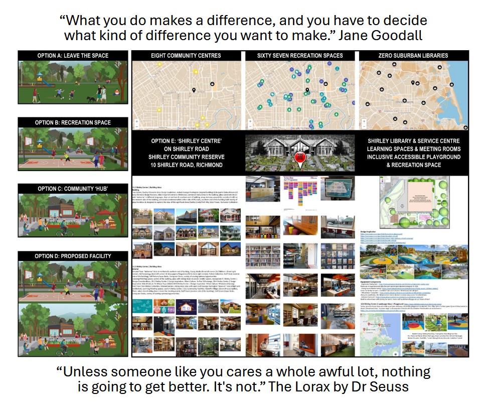
– Shirley Community Centre (10 Shirley Road): A centerpiece of the neighborhood originally built in 1915 as Shirley School. The historic Category 2 building was heavily compromised by the shaking and demolished in 2012.” AI Overview
Since 2012, residents have been asking Council to reinstate their Community Centre at 10 Shirley Road.
https://www.10shirleyroad.org.nz/shirley-community-centre-decision-making/
‘Christchurch suburb overlooked since the earthquakes, community leaders say’ (30th April 2018)
https://www.stuff.co.nz/the-press/news/103484014/christchurch-suburb-overlooked-since-the-earthquakes-community-leaders-say
“Our ward has been forgotten in many ways, particularly the Shirley area – an area that is in the east but not in the east we hear so much about. No big pool complex or hot pools here,” [Former] Papanui Innes Community Board chairwoman Ali Jones said referring to facilities being built in neighbouring wards.
“The community is close to breaking point. They need a place to meet, to gather, to mend.”
When asked by a councillor how the council would pay for more facilities in the area, Jones said maybe other wards could cut back on some of the facilities they were asking for.
[Former] Christchurch Mayor Lianne Dalziel said reinstating a community centre in Shirley would have to be weighed up against all the other challenges facing the city.
“You do need to take a city view when you sit around this table. You can’t take a ward by ward view. We have to work out ways of making sure we have enough money on budget to do what is absolutely core critical across the city.”
Coastal-Burwood Community Board members also made a plea to the council for greater investment in the area to give it equity with the rest of the city.
The Shirley Community Centre, once a busy focal point providing a home to many different groups, was demolished following the 2010/11 earthquakes and has yet to be rebuilt. No money has been allocated in the LTP to build a replacement facility.
Shirley resident Joanna Gould said the community had become displaced since the demolition of the community centre.
“There is no one place to go to ask for help.”
Gould has created a website to push for a new joint library, learning centre, service centre, playground and playcentre at the site.”
Since 2018, I have been researching & advocating for my ‘Shirley Centre’ vision, to benefit the residents living in the communities around Shirley Road:
Shirley, Dallington, Richmond, Edgeware, St Albans & Mairehau.
https://www.10shirleyroad.org.nz/joanna-gould-submissions/
During this year’s Christchurch City Council 2026 Draft Annual Plan hearings, I appealed to Council & Councillors to ‘Cancel the Plan’ & reallocate the funding on budget into the 2027 LTP for the ‘Shirley Centre’.
Following my verbal submission, I created the below Blog Post series:
– Blog Post #1: CCC Draft Annual Plan 2026-2027
– Blog Post #2: Facility Decision-making
– Blog Post #3: Equity and Inclusion
– Blog Post #4: ‘Gateway to the East’
– Blog Post #5: ‘Cancel’ Plan or ‘Rip Up’ Policy?
In May 2026, I wrote the following Blog Post: ‘The Big Picture’:
“‘The Big Picture’ planning & development of the 10 Shirley Road site: Shirley Community Reserve, should focus on these 3 questions & 2 answers:
1. Q.1. Land?
– What can & can not be done with the Land?
2. Q.2. Council?
– What are the relevant Council plans, policies & strategies?
3. Q.3. Community?
– What does the Community want & need?
4. A.1. = Options
– What are the different scenarios currently available?
5. A.2. = Funding
– What are the different funding options available?”
I had hoped that after reading all my research over the years & understanding our communities needs, Councillors wouldn’t think ‘not my people, not my problem’…
But would act on our communities behalf, to ‘Cancel the Plan’ during their Workshops to finalise the Christchurch City Council Annual Plan for 2026 & rethink the plans for 10 Shirley Road.
Unfortunately this week I was notified by a Chancellor Street resident that a Christchurch City Council ‘Works Notice’ had been delivered to their letterbox:
‘Shirley Community Reserve – facility construction’
https://ccc.govt.nz/transport/works-3/show/2056
– What: Christchurch City Council is building a community facility [no longer called the ‘Shirley Community Centre’] at Shirley Community Reserve.
– Why: To deliver a community facility available for hire by local groups, along with public restrooms and an improved car park for park visitors.
[Existing car park reduced from 29 spaces to 16 spaces: 14 with 2 Mobility Car Parks.
This will have a negative impact on Shirley Playcentre & Shirley Primary School car park users.]
– Where: 10 Shirley Road, Shirley [Richmond].
– When: Early July 2026 to late December 2026. Monday to Friday, 7am to 6pm (weather/site condition dependent).
I am beyond disappointed. This is not the outcome I had hoped for our communities most valuable (history, heritage, reserve, accessible) site/land.
Residents in our communities surrounding Shirley Road, have been waiting patiently for their turn, to have their well used Community Centre rebuilt…
Paying their rates while watching other communities in Christchurch get their new (not all earthquake rebuilds) community facilities built & opened for their residents to enjoy.
The ‘Shirley Community Centre’ (1,500m2, Category 2 historic place) is the last remaining community facility, that was part of the Christchurch City Council’s original ‘Community Facilities Rebuild Programme’ to be rebuilt after the earthquakes.
‘Shirley Community Facility’ Written Submission by Joanna Gould (Sept 2025)
.pdf: https://www.10shirleyroad.org.nz/wp-content/uploads/2026/03/WaipapaPICItem8ShirleyCommunityFacilitySept2025JoannaGould.pdf
‘Shirley Community Facility’ Written Submission by Joanna Gould (Dec 2025)
.pdf: https://www.10shirleyroad.org.nz/wp-content/uploads/2025/12/WaipapaPICItem9ShirleyCommunityFacilityDec2025JoannaGould.pdf
At their 11th December 2025 meeting, the Waipapa Papanui-Innes-Central Community Board approved plans for the ‘Shirley Community Facility’.
https://www.10shirleyroad.org.nz/shirley-community-facility-plan-v2/
The new Shirley Community Reserve ‘Community Facility’:
– 280m2 building
– For Hire only: function room, a kitchen, office space, two meeting rooms & four internal toilets.
– Free Access: two external public toilets.
So after researching, advocating, filling in surveys/consultations, making deputations/submissions, ‘activation’ of the site, organising/presenting a petition & waiting since 2012 for a new building to ‘replace’ our former Centre…
The Waipapa Papanui Innes Central Community Board & Christchurch City Council have come to the conclusion, that what our communities really need at the most visible & accessible location on Shirley Road, is free access to two external public toilets?
Where is the equity?
https://www.10shirleyroad.org.nz/equity-and-inclusion/
How does this new ‘Community Facility’ include residents in our communities, who are socially isolated due to financial constraints?
Our current residents & future generations living in these communities around Shirley Road, have been let down by:
– our Innes (Pauline Cotter) & Central (Jake McLellan) Ward Councillors (10 Shirley Road site was originally in the Innes Ward, now in the Central Ward),
– the Waipapa Papanui Innes Central Community Board for approving this plan &
– our current Christchurch City Councillors who could have chosen to ‘Cancel the Plan’ & advocate for a new design to be created, for a fit-for-purpose building that aligns with the ‘Equity and Inclusion Policy’, to meet our communities needs.
Christchurch City Council, please rip up your ‘Equity and Inclusion Policy’, as this new ‘Community Facility’ at 10 Shirley Road does not align with your policy definitions.