‘Cancel’ Plan or ‘Rip Up’ Policy? | Summary
1. ‘Cancel’ Plan
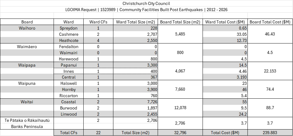
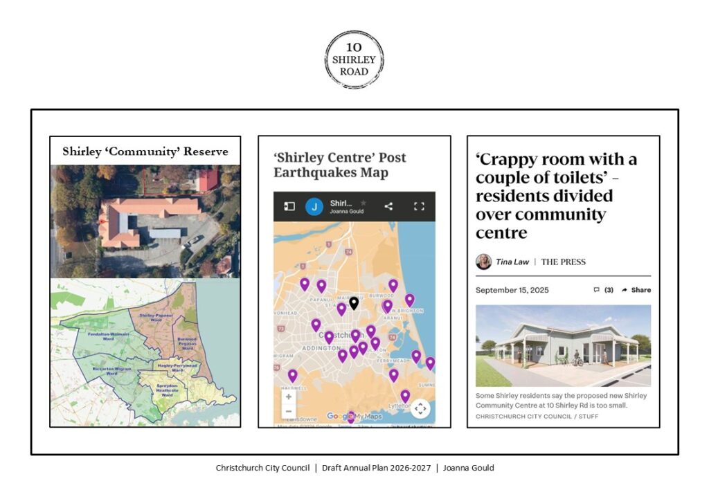
1.1. Waipapa Papanui-Innes-Central Community Board Approved Plan
1.2. ‘Shirley Community Facility’
1.3. ECAN Application for Resource Consent
1.4. “Sunk Capital” = MacFarlane Park?
1.5. Remove Delegated Authority
2. ‘Rip Up’ Policy
2.1. Christchurch City Council Equity and Inclusion Policy
2.2. ‘Shirley Centre’
2.3. Stakeholder Discussions
2.4. Concept Design Consultation
3. Land & Location
3.1. Land Information
3.2. Shirley Playcentre
3.3. Shirley Community Reserve Playground
3.4. Location Information
4. Building: What?
4.1. Community: Needs & Reach
4.2. CCC Community Facilities Network Plan
4.3. CCC Best Practice Community Facility Design
4.4. CCC Libraries 2025 Facilities Plan
4.5. ReVision Youth Friendly Spaces Audits
5. Design: How?
‘Shirley Community Facility’ Design Issues
5.1. Intergenerational
5.2. Universal
5.3. Sensory Friendly
5.4. Culture
5.5. Heritage
5.6. Biophilic
5.7. Environmental
5.8. Sustainable
5.9. Crime Prevention Through Environmental Design (CPTED)
‘Cancel’ Plan or ‘Rip Up’ Policy? | Summary
This post is the last in this Blog Post series:
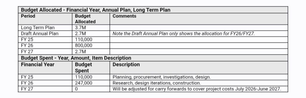
1. CCC Draft Annual Plan 2026-2027
2. Facility Decision-making
3. Equity and Inclusion
4. ‘Gateway to the East’
During my verbal submission for the CCC Draft Annual Plan 2026-2027, my ‘Call to Action’:
– Cancel the plan, reallocate & increase the LTP budget for the Shirley Centre.
– Remove the Delegated Authority &
– Start discussions with both Boards & other stakeholders that were excluded from the decision-making process.
– Advocate for the ‘Shirley Centre’, Library & Information Centre on Shirley Road, as the ‘Gateway to the East’.
“Otherwise, if this plan gets built, you as the Council, are literally ripping up the Equity and Inclusion Policy, for the residents in the communities around the Shirley Community Reserve.”
1. ‘Cancel’ Plan
1.1. Waipapa Papanui-Innes-Central Community Board Approved Plan
Shirley Community Facility Plan v1
Shirley Community Facility Plan v2
– The endorsement of the plan by the Working Group was not unanimous.
– The endorsement of the plan by the Community Board was not unanimous.
1.2. ‘Shirley Community Facility’
Shirley Community Reserve | Updated Feasibility Study (2023) (Page 77)
“It should not be assumed that if the Council establishes a new community building that it will be well used.
Identifying community groups and classes to have regular bookings alongside casual bookings for birthdays and celebrations requires activation and resources.”
‘Activation’ of a ‘Venue for Hire’ Community Facility requires two participants:
– Activity Providers/Community Groups who can afford to ‘hire the venue’ &
– Residents who can afford to ‘pay to attend’ the activity/event.
In a review of the ‘Local Activities Available’ at our existing Community Centres & Shirley Library:
– Most activities are held between 10am – 2pm.
– The main type of ‘Activity’ currently provided is physical exercise related.
– Limited Activities available for preschoolers, children & youth.
– Limited Activities after the 2pm time slot.
– Limited Activities on the weekend.
– Shirley Library is the top ‘Location’ provider for ‘free’ activities.
1.3. ECAN Application for Resource Consent
‘Shirley Community Centre’ | ECAN Application for Resource Consent
– Existing car park reduced* from 29 spaces to 16:
[14 with 2 Mobility Car Parks] & 7 bike racks added. (Page 5)
* These car parks are also used by Shirley Playcentre (see 3.2. “requirement that four car parks be provided”) & Shirley Primary School.
– Once completed, the facility will be available for hire by community groups and the general public.
– The facility will not be staffed full time on a regular basis.
– Hours of operation will be 7 days a week, including public holidays, however, the hiring time frame will be limited to 10pm at the latest to ensure that it will comply with the relevant District Plan standards around noise (chapter 6.1). (Page 6)
– …this area has been recently rezoned to Medium Density Residential (MRZ notation below), and High Density Residential (HRZ) to the east. These areas may therefore develop into higher residential activity in the future. (Page 7)
– …the Record of Title shows that the Purpose of the allotment is “in trust for local purpose (site for a community centre)”. (Page 9)
– While not being located within the Character Area overlay, the building is designed in a sympathetic manner which recognises its roots as a former heritage setting and proximity to the existing heritage values in the Character Area.
– The design results in a more efficient use of the land, mitigating the hazard risks beyond that strictly necessary under the District Plan.
– The reduced hardstand/car parking and increased cycle parking, and the proximity to the bus stop all help enable more active and public transport options. (Page 17)
– The works will maintain the purpose of the reserve, noting that the site is set aside for a community facility.
– The building is to be made available for the anticipated existing and future community needs, noting the projected future increase in population signalled by the recent urban intensification zonings.
– The design reflects the local heritage values, with its heritage features, single storey design and attractive interfaces visible from all boundaries.
– The building will be designed to CPTED principles, with clear sight lines maintained from all boundaries, territorial reinforcement by design, and maintenance. (Page 19)
1.4. “Sunk Capital” = MacFarlane Park?
During my verbal submission, Councillor Pauline Cotter (Innes Ward) said:
“There’s a lot of money already gone into this. What’s your view on the sunk capital that we would lose…”
Solution: Reuse the ‘Shirley Community Facility, 100% Developed Design‘ Plans…
Waipapa Papanui-Innes-Central Community Board | Draft Priorities 2026-2028
MacFarlane Park: Revitalising MacFarlane Park and the wider area is important to the Board as it strengthens neighbourhood identity, safety, and everyday use. Upgrading outdated spaces and amenities, improving access, and creating a more welcoming environment will increase community pride and encourage more time spent in the park.
Boffa Miskell | MacFarlane Park CPTED Review
Limiting Views, No Reliable Supervision of the Park (Page 2):
The CPTED review has concluded that the key CPTED challenge for this park is the internalised layout, limiting views into the park from the streets and creating CPTED risks due to a lack of supervision.
There is no reliable supervision of the park which means safety of the park is reliant on supervision from other users within the park.
The community-based facilities will need renewal at varying times and this does pose an opportunity to consolidate facilities and allow more views into the park from surroundings.
Public Toilets and Rugby Store Shed (Page 7):
The location of these buildings has no passive supervision, nor is aligned with complementary facilities (such as a playground). The toilets are up for renewal in the next 5-years and this is evident with the poor quality of these facilities.
Co-Studio Architects | ‘Shirley Community Facility, 100% Developed Design’
Page 40 & 42 (without ‘Colonial’ details, see example ‘North Elevation’ Page 51)
Location Option 1: 17 Acheson Avenue
MacFarlane Park Neighbourhood Centre/Shirley Community Trust
This Option would allow better visibility along Acheson Avenue & into the Park, connecting the new building to the existing footpath & car parks on Acheson Avenue.
– Remove the current ‘Public Toilets and Rugby Store Shed’ on the Park.
– Remove the current building, due to age/size & limited ability to ‘see into the building’ & ‘see out to the Park’.
– Replace the current building with the ‘Shirley Community Facility, 100% Developed Design‘ Plan (without ‘Colonial’ details):
Larger open plan space, plenty of large windows to ‘see into the building’ & ‘see out to the Park’.
Internal/External toilets (closer to playground/basketball court, lockable at night) & storage room to replace the current ‘Public Toilets and Rugby Store Shed’.
– Building Placement: Vertical (MacFarlane Park Centre on the Park is Horizontal.)
Short side of the building facing Acheson Avenue,
Long side of the building facing the Service Lane/Emmett Street.
Location Option 2: MacFarlane Park, behind 4 Skipton Street
This Option would allow better visibility through the Park only, connecting the new building to a new West side path (from the South to the North), but further away from the car parks on Acheson Avenue.
– Remove the current ‘Public Toilets and Rugby Store Shed’ on the Park.
– Add the ‘Shirley Community Facility, 100% Developed Design‘ Plan on the Park:
Closer to the Sports Fields & Playground. Internal/External (lockable at night) & storage room to replace the current ‘Public Toilets and Rugby Store Shed’.
– Building Placement: Vertical (MacFarlane Park Centre on the Park is Horizontal.)
Short side of the building facing Acheson Avenue,
Long side of the building facing Sports Field/Emmett Street.
New Building Fund Opportunities: Christchurch City Council, the Lottery Grants Board, NZ Community Trust, Rātā Foundation, Shirley Community Trust, Clubs/Users of the Sports Field & fundraising events similar to Edgeware Pool.
1.5. Remove Delegated Authority
Proposed Shirley Community Centre Rebuild Request for Delegated Authority
8th September 2016, Item 12., Page 5
“That the Council:
1. Delegates the necessary authority (as per the St Albans Community facility*) to the Shirley/Papanui Community Board (to be the Papanui/Innes Community Board in the next term) for decisions regarding the rebuild and future management of the Shirley Community Centre at either 10 Shirley Road or any other selected site.”
* The Board hasn’t follow the same process of engagement & decision-making for the 10 Shirley Road site, “as per the St Albans Community facility”.
Prior Community Board Proposals:
– Crossway Church Proposal (2016):
From 2013 to 2016, “staff explored options for a third-party funded and managed facility”, which was eventually rejected.
– CCC Draft LTP 2024-34 Workshops (May 2024):
Proposed amendment by Councillor Pauline Cotter.
“Staff are through the Board Chair [Emma Norrish] currently negotiating with a ‘prospective Community Partner’ [‘Shirley Road Central’] and a ‘sympathetic Building Company’ [Property Developer] to develop this facility in a Community Partnership through the Build and the Operation.”
15 years after the Canterbury Earthquakes, our communities around Shirley Road are still waiting for a new building to be built, with very little progress achieved by the Board over the last ten years.
The wording/Options available in the Consultations, the selection of the Working Party members & design/approved plans by the Board, has caused further divisions within our communities.
The Waipapa Papanui-Innes-Central Community Board meeting agenda for the 13th June 2024, included the Council Staff report for the ‘Shirley Community Reserve: Proposed Community Facility’:
“Options Considered: Investigate the relocation of Shirley Library (Page 34 – 35)
4.25 The following options were considered but ruled out:
The LTP budget for Shirley Community Centre would be insufficient to include the relocation of Shirley Library…”
There is no ‘Suburban’ Library in the Innes or Central Ward, Shirley Community Reserve is on the boundary of both Wards.
Our ‘Suburban’ Libraries are core community infrastructure. These community facilities are ‘free to enter’, ‘a place to be’, inclusive & accessible for the majority of our residents.
The current Shirley Library is located in ‘The Palms’ car park, not a ‘destination space’, in a Commercial zone, with limited floor space & bookshelves, no Learning Spaces/Meeting Rooms/Outdoor Space or Toilets within the Library area.
Yet from 2020 to 2026, Shirley Library visitor numbers ranked:
20/21 = 3rd, 21/22 = 2nd, 22/23 = 1st, 23/24 = 2nd, 24/25 = 3rd, 25/26 = 1st
(for a ‘Suburban’ Library).
Why didn’t our Board advocate for all their residents in the Innes/Central areas during the Christchurch City Council LTP 2024-34 decision-making process & ask Council to approve an appropriate new budget to build a new ‘Shirley Centre’/relocate Shirley Library & Service Centre, from the Burwood Ward to the Central Ward at 10 Shirley Road, Richmond?
2. ‘Rip Up’ Policy
2.1. Christchurch City Council Equity and Inclusion Policy
The current plan doesn’t align with the Christchurch City Council Strengthening Communities Together Strategy:
– People: The city actively promotes a culture of equity by valuing diversity and fostering inclusion across communities and generations.
– Place: We help build connections between communities and their places and spaces to foster a sense of local identity, shared experience and stewardship.
– Participation: Residents and groups in the wider community are socially and actively engaged and able to initiate and influence decisions that affect their lives.
Nor the Christchurch City Council Equity and Inclusion Policy:
– Equity: Recognises that each person has different circumstances and allocates the exact resources and opportunities needed to reach an equal outcome.
– Inclusion: The practice or policy of providing equitable access to opportunities and resources for people who might otherwise be excluded or marginalised, such as those who have physical, hidden, or mental disabilities and members of other minority and disadvantaged groups.
The current plan is non-inclusive & the facility will be inaccessible for many residents:
– Facility Operation: ‘Venue for Hire’
– Access for Hirers: $ Hire Fee, with Swipe Card access
– Access for Residents: Restricted, $ cost to attend activities
– Activities Available: Restricted, to what Hirers will provide
– Age Restrictions: Based on Activities Available & Time Slot
– Building Location: Back of the Reserve, less visible from the surrounding streets.
– Mobility Access: Bus users will need to be able to walk the distance to the back of the Reserve to attend the Facility.
– Footpath Access: No access to the Facility from Shirley Road in the current plan.
– Car Park Access: Half of the existing on site car parks have been removed from the Reserve in the current plan. Facility users will be sharing the limited on site car parks with Shirley Playcentre & Shirley Primary School.
2.2. ‘Shirley Centre’
The ‘Shirley Centre’ vision has been based on the building/site being:
Inclusive & Accessible:
– Location Location Location
– ‘Shirley Centre’ | Transport
– ‘Shirley Centre’ | Support Providers
By “incorporating the current Shirley Library”, as a Citizen Hub the building would be ‘Open’ & ‘Free to Enter’ during the existing Shirley Library hours:
Monday to Friday from 9am to 6pm, Saturday & Sunday from 10am to 4pm.
After Hours Access?: ‘Open Plus’ | Manawatū Community Hub Libraries (MCHL)
“Open Plus is a free service available to everyone in the Manawatū community, providing secure, self-service access to the hub outside of staffed hours. Signing up is as simple as bringing your membership card and a form of ID to the front counter for registration.”
The building/site vision has been based on the design principles included in:
‘5. Design: How?’, with the following:
– ‘Shirley Centre’ | Building Ideas
– ‘Shirley Centre’ | Landscape Ideas
– ‘Shirley Centre’ | Playground Ideas
2.3. Stakeholder Discussions
The 10 Shirley Road site is surrounded by suburbs from 3 different Wards:
– Innes Ward: St Albans (East of Cranford Street), Edgeware, Mairehau & Shirley West
– Burwood Ward: Shirley East & Dallington
– Central Ward: Richmond.
Decisions regarding a building at the 10 Shirley Road site should involve both:
– Waipapa Papanui-Innes-Central Community Board &
– Waitai Coastal-Burwood-Linwood Community Board.
Especially considering the current Shirley Library is located in Shirley East (part of the Burwood Ward) & since my submission in 2018, for the rebuild of the Shirley Community Centre to include “incorporating the current Shirley Library”, as a Citizen Hub.
Plus Stakeholders previously excluded from the Working Party:
– Shirley Playcentre (located on the Reserve)**
– Shirley Primary School (located opposite the Reserve)**
** The current plan has halved onsite car parking at the Reserve, which will affect these car park users.
– Shirley Recreational Walkers (meet at the Reserve)
– Canterbury Genealogy (formerly NZ Society of Genealogists – Canterbury Branch. Located at 10 Shirley Road from February 1990 until the February 2011 earthquakes. Now located at Parkview Community Lounge, with drop-in sessions at Shirley Library on the first and third Saturdays of each month.)
– Community Advocates/Residents from the communities around Shirley Road.
Christchurch City Council Delegations Register (Page 97 & 98)
Community Facilities:
1. To approve site selection and to approve the final design of new local community facilities (for example community halls, volunteer libraries, club rooms, public toilets). Limits:
– This power may not be sub-delegated.
– Any financial decisions are subject to the maximum of what is approved in the current LTP/Annual Plan and associated cost centre budgets.
– This delegation does not include community facilities that have network or citizen hub implications. For example swimming pools, libraries, and multi-use service centres.
2.4. Concept Design Consultation
– At no stage in the process of developing the ‘Shirley Community Facility’, has there been a Consultation on the ‘Concept’, ‘Developed Design’ or ‘Detailed Design’, to allow the whole community to give feedback on their community facility.
– The current plan is the opposite of what our residents in the communities around Shirley Road need & asked for in their 2023 Consultation feedback & in the ReVision Youth Friendly Spaces Audits.
3. Land & Location
3.1. Land Information

36 Marshland Road (Current Shirley Library)
3.2. Shirley Playcentre
Shirley Playcentre | Lease (2000)
approx. 769 m2 of Shirley Community Centre Reserve
– The Canterbury Playcentre Association has had a [new] building designed to fit the site. Officers requested that the building be designed to incorporate the equipment shed, which is usually separate from the main building on other play centre sites, the reason being that this site is an historic site with the historic Shirley Primary School buildings being the main feature on the site.
– Officers therefore wanted to ensure that the new building was designed to fit in with the character of the site.
– There is a requirement that four car parks be provided, one for staff and three for parents attending the playcentre.
– There are car parks on the Shirley Community Centre Reserve to cater for on site car parking requirements, however the Council will not designate any of the car parks specifically for this purpose, the car parks being for Shirley Community Centre/Playcentre use as a whole.
– The main entrance to the playcentre is to be from the Community Centre car park which is accessed off Slater Street, thereby ensuring the safety of children by not requiring them to access the site from Chancellor Street which is adjacent to the playcentre.
3.3. Shirley Community Reserve Playground
CCC Play Equipment (Open Data) Map
– Site Name: PRK_0666 – Shirley Community Reserve
– Swing: 1998 (2 Infant Seats, 2 Standard Seats)
– See-Saw: 1998
– Slide (2), Climbing Net, Firemans Pole, Tunnel: 2010?
Shirley Community Reserve | Updated Feasibility Study (2023) (Page 77)
– The current play provisions in this area are older and in need of refurbishment, namely the play space next to the Shirley Playcentre.
– There is an opportunity to provide for inclusive play as the Community Reserve is already currently fenced, which is rare in Christchurch, particularly in the area north of Bealey Avenue.
– With the addition of a couple of gates, this would enable the space to be a fenced playground, which is something the Disability community is advocating for more of, in particular the Autism community in Christchurch.
3.4. Location Information

36 Marshland Road (Current Shirley Library)
4. Building: What?
4.1. Community: Needs & Reach
The table below highlights the different examples of Community Facilities available in the Innes & Central Wards, based on:
– Metropolitan (City)
– Ward (Multiple Suburbs)
– Local (Community)
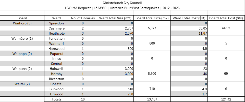
The only ‘gap’ is in ‘Libraries’, no ‘Suburban’ libraries in the Innes or Central Ward.
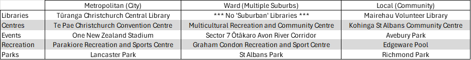
Innes & Central Wards | Community: Needs & Reach
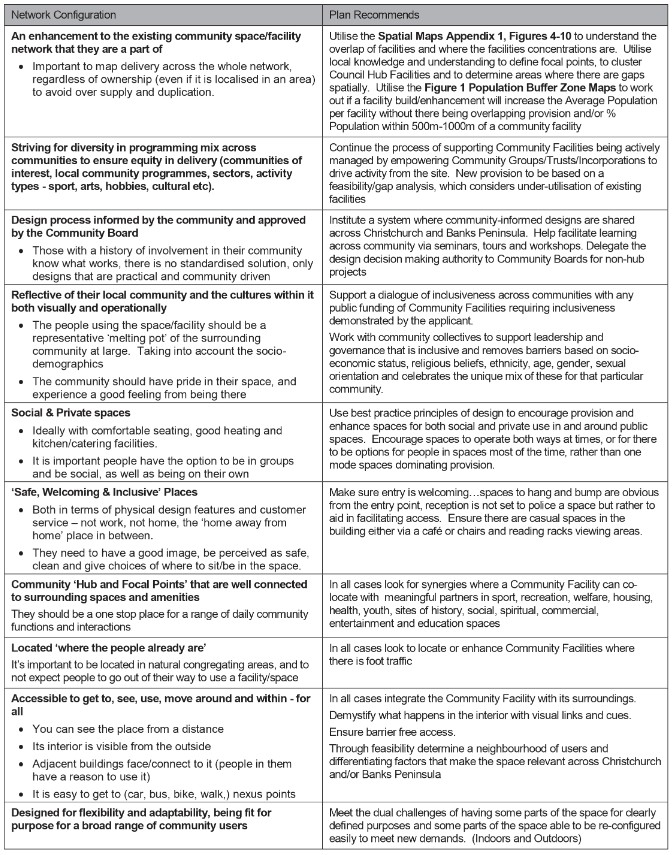
4.2. CCC Community Facilities Network Plan
Christchurch City Council | Community Facilities Network Plan
Trends toward hubs and focal points (Page 48 – 49):
Worldwide trends tell us Community Facilities will be focal points in the community and will become known as neighbourhood and communal gathering places of flexible spaces that allow people to work/play/be/meet together in groups or work/play/be alone but connected to others outside of their homes.
They will facilitate enquiry, self-reflection, social interaction, formal and informal activity. A trend is to hub significant facilities as part of community focal points.
Facility Activation – The Value Proposition (Page 56):
It is important in the implementation phase of the CFNP to ask the question, “what will lead to the highest activation of the facilities?”
By this we mean not just levels of us, ‘utilisation’, but also the mode and types of use to meet wider community needs for bumping space, for learning space and social spaces.
The lowest form of activation is to make the facility ‘available’ to the community as a vessel-for-hire. The highest form is programmed space.
The programmed facilities will have participants from a wider and more diverse cross-section of the population which typically includes those people who have access difficulties including but not limited to:
– Those groups/individuals who find cost to participate a barrier
– Those groups/individuals who find physical access a barrier
– Those who have difficulties in social space, or issues with formalised situations
– Time as a barrier (working or family care related)
– Age, ethnicity, gender, sexual orientation as barriers
Programmed space tailors activities to overcome barriers to participation including those listed above.
In programmed space some users will have ‘free’ access while others may pay more for value added services.
The beauty of this approach is that it still enables vessel-for-hire provision alongside programmed usage.
Facility Location Significance (Page 57):
Some facilities are better suited to be hub locations based on their centrality within a neighbourhood/rural community, geographical location, accessibility and proximity to other hub or key locations such as libraries, social and community outdoor spaces, cafes, economic and commercial centres including malls and or proximity to aligned activity, school/education, church, sport and play related.
Ward and Neighbourhood Significance (Page 57):
At the network level where there are potential hub facilities, the approach is to support their development as Council owned and operated site.
Hub facilities are where there is co-location and clustering of services: library; service centre; community activity; recreation and sport; civic activity; culture, meeting and public assembly; education and arts activity.
4.3. CCC Best Practice Community Facility Design
Christchurch City Council | Community Facilities Network Plan
Best Practice Community Facility Design (Page 54):
Best Practice Community Facility Design
AI Overview: Best practice for community facility design in Christchurch emphasizes creating flexible, accessible, and durable “hubs” that foster social connection and resilience. Key principles include integrating with local, walkable transport networks, adopting sustainable and culturally reflective design (incorporating te reo me ona tikanga), and engaging with the community to ensure spaces meet local needs and encourage active participation.
Key Design Principles & Best Practices:
– Resilience & Safety: Post-earthquake standards are critical, with an emphasis on durable materials, seismic safety, and designing facilities that can serve as hubs during emergencies.
– Flexibility & Multi-use: Spaces should be adaptable for diverse uses, including, but not limited to, community events, educational activities, and meetings to ensure high usage.
– Accessibility & Inclusivity: Spaces must be welcoming and functional for people of all ages and abilities, reducing congestion with spacious layouts.
– Co-location & Integration: Prioritize locating new facilities near schools, transport corridors, or other community hubs to improve accessibility and create vibrant activity centers. Focus on establishing “hubs” within neighborhoods that enhance, rather than replace, existing local infrastructure.
– Community-Led Design: Engage stakeholders early in the process to ensure the design meets specific local needs and fosters a sense of ownership.
– Sustainability & Environment: Integrate environmental considerations, such as sustainable building materials, energy efficiency, and low-impact designs.
– Safety & Connection: Designing with good visibility, safe entryways, and connections to public open spaces encourages a sense of belonging and safety.
– Local Identity: Facilities should reflect the character of their neighborhood and acknowledge local history.
Specific Design Elements:
– Outdoor Connections: Include spaces like sensory gardens, playgrounds, and recreational areas that link to surrounding green spaces.
– Open, Airy Interiors: Use clear-span designs to allow for large, flexible, and well-lit spaces.
– Street Engagement: Ensure public spaces “front” on to streets, encouraging safety and interaction.
– Accessibility & Inclusion: Use clear signage and consider the needs of all ages and cultures, including children.
– Safety: Prioritise good visibility to ensure safety.
These practices align with the Council’s Urban Design principles to ensure that the city’s infrastructure and community facilities support active, connected, and resilient communities.
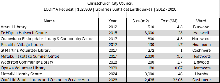
4.4. CCC Libraries 2025 Facilities Plan
Christchurch City Council | Libraries 2025 Facilities Plan
Role of library facilities in communities (Page 10):
– Important, central meeting place and focal point in a community.
– Open, spacious, welcoming environment; warm place to be in winter; vital social contact for many (especially older persons); place to meet (café) and relax with children and friends or family.
– Outstanding location (e.g. overlooking ocean, park setting) – source of community pride, for the building and the resources available.
– Access to a diverse range of reading materials – books, magazines, children’s and talking books; Central Library used by people for the value and depth of collection and there are more items from which to choose.
– Free learning environment; provider of ‘second chance’ opportunities for adults wanting to learn.
– Provider of general services, e.g. photocopiers, community/local information.
Location preferences (Page 10):
– Near local shops/supermarket/mall/bank/medical centre/schools/playground/toy library;
malls and aquatic facilities not seen as highly desirable areas for co-location
or as adjacent locations;
co-location with a Council service centre favoured.
– On bus route/near transport hubs; handy walking distance from home; easily accessed, free, plentiful car parking adjacent to library.
– Attractive street visibility.
Building requirements – needs and expectations (Page 10):
– Spaciousness – cafes; room for quiet spaces away from bustle of café and children’s area; generous space between book stack aisles to enable easy browsing by less nimble and multiple users at one time; plenty of chairs/ beanbags and desks at which to work/relax.
– Whanau-friendly facilities, e.g. children’s areas, baby feeding/changing facilities.
– Outdoor environment important – need natural features and to be welcoming; clear signposting within and outside the building.
– Accessible buildings and facilities for people with disabilities.
– Small local libraries – easy to find way around.
– Good infrastructure and building design (air conditioning, etc).

Based on ‘Location Preferences’ & ‘Building Requirements’
4.5. ReVision Youth Friendly Spaces Audits
ReVision Youth Audit | 10 Shirley Road
– The youth auditors really liked how the space is well connected within Shirley.
10 Shirley Road is right in the middle of other spaces local young people would access and is surrounded by bus stops connected to the central network.
– The space has a variety of facilities for young people to use, such as the playground, basketball court, and a quiet space by the stream at the other end of the park.
– They enjoy using the space as it is easily accessible and its activities give them something to do, while making them feel like they belong.
– The areas young people thought could be improved on were the lack of basic amenities in the space and the underutilisation of the space.
– One youth auditor mentioned that Shirley Primary, located across the road, uses the space sometimes, which makes it easier for kids to feel welcome to use the space.
– Overall, it is a nice and safe park, with one auditor even commenting that it was enjoyable for all people, young or old, to use.
– Another idea the auditors raised was to add an information board which includes youth-focused information and advertising.
It should also include contacts to youth services and providers, in both Shirley and neighbouring areas. This will help young people feel comfortable with accessing support and could possibly introduce them to new groups and clubs.
– In the long run, young people would like to see a youth centre or a place where young people can sit down and relax in a sheltered space which protects them from the elements.
– During the day, they mentioned that the space feels safe due to its location on the main road and open areas. However, when dark, the auditors noted that they did not feel the same level of safety.
– Another auditor mentioned that they would feel safe if more people were around.
This could be achieved by adding more seating to attract more users and introducing more activities.
– When asked if they felt ‘in the way’ when at the space, the auditors said that they did not and that they instead felt welcome by its other users; they felt that they were part of the community.
– In terms of new activities, the auditors noted that the table tennis table is not fit for purpose as it is usually too windy to use. Instead, the auditors suggested that a big chess set could be developed, which would be something young people would welcome to the space.
– Any space needs to be accessible, which includes disability access, physical movement to and around the space, and the affordability of engaging with the space.
Young people commented that the space is easily accessible.
– Due to its location on a main road, the space is easy for not just Shirley residents to access, but everyone in the city.
– A traffic light installed right outside the main entrance makes it easier for young people to cross the road, while the bus stops located directly outside the space connect it to the city’s public transport network that many young people rely on.
– With council already planning to build a new structure in the space, the youth auditors agreed that they would like this to be a building that would be a place to both run activities and relax.
ReVision Youth Audit | Shirley Library
-The youth space was a key area the young people identified as needing change. Specifically, they wanted to see this space moved to a different area of the library.
Young people don’t want to have a space that is at the back corner of the library.
A young person suggested that they would change the layout to be more obvious where the youth space was and would make it larger.
Another auditor really wanted to have a space that was at the heart of the library and was slightly removed at the same time.
– Another common recommendation that young people felt would make the place livelier would be to add more plants and greenery.
Not only would this create a ‘better vibe’ as one auditor said, but the young people felt that it would make the Shirley Library feel even more homely.
– The suggestion of more chairs and comfy places to sit such as more bean bags etc. was also raised again within this discussion around resourcing.
This highlights a strong consensus that the Shirley Library should have more places for both young people and all library users to sit.
– The young people felt that there could be more toilets available for users in the library and also some gender neutral options that weren’t the disabled toilets.
– When asked if the space reflected their culture many of the young people said that it doesn’t feel multicultural and that they would love to see more Te Ao Māori and Te Reo Māori around the space.
– Young people wanted to feel included in decision making on clubs and activities for them and suggested providing different avenues for them to continue to do this. With this, they also wished to see a greater circulation of young adult books and the Shirley Library to be better resourced with activities and clubs for them.
– A couple of young people highlighted how dark the mall and library car park were and this increased how unsafe they felt leaving the Library.
5. Design: How?
‘Shirley Community Facility’ Design Issues:
1. Building Placement:
– Building located at the back of Reserve, not up front & connected to Shirley Road, hidden down the back.
– Not centred on the Reserve, like the previous Community Centre, doesn’t line up with the path from Shirley Road.
– Line of sight from Shirley Road to Dudley Creek, blocked by the south wall of the building.
– CPTED (Crime Prevention Through Environmental Design) issues with the south wall of the building.
2. Dudley Creek:
– Dudley Creek is the Reserve’s best asset. The building should be connected to the south of the Reserve.
– There are no windows or doors on the south side of the building. This is the best view of the Dudley Creek area.
3. Dudley Character Design:
– Gable or hip roofs that are consistent with adjacent residential buildings, like the former building. The roof pitch is not the same.
– There is no Entry Porch/Front Door orientated to face Shirley Road.
– Too many doors on the building facing Shirley Road/Chancellor Street, adds to the confusion of where is the Entry?
– The side Entry door connected to the car park is convenient for those using that car park, but what about bus users & those who have parked on the other streets?
– Floor to ceiling glass doors are not in keeping with the style of Front Doors on the surrounding residential buildings.
– The new building does not have symmetrical large front windows facing the street, like the former building.
4. Interior/Exterior Design:
– Will any of the items retrieved from the former Heritage Listed building be incorporated into this new building?
– This is a Civic building, yet there is no Māori design principles (Te Aranga) incorporated into the new building?
5. Car Park:
– The car park spaces have been reduced, which will affect Shirley Playcentre & Shirley Primary School.
– The new car park is no longer connected to the path that goes from Slater Street to Chancellor Street.
6. Paths:
– The former building was connected to all the current paths, plus it also had a path down the east side of the building, past the playground, Shirley Playcentre to South car park.
– The new building is not connected to Shirley Road, the playground or Shirley Playcentre.
7. Toilets & Kitchen:
– There are no windows for the toilets or kitchen. No natural light, so it will cost more for electricity & lights will need to be put on a sensor, so that they aren’t left on.
– The kitchen & toilets will each need to be fitted with a ventilation system, as there are no windows to allow in fresh air.
These will also need to be on a sensor, so that they aren’t left on.
5.1. Intergenerational
AI Overview: Intergenerational design creates spaces, products, and communities that foster connection, empathy, and mutual benefit across different age groups.
It merges universal accessibility with social architecture, aiming to combat loneliness and enhance social cohesion by designing environments that bring generations together.
Key Principles and Elements:
– Universal Design: Environments are accessible, safe, and usable for everyone, from children to seniors, often removing stairs and widening doorways.
– Purposeful Interaction: Spaces, like community gardens or shared seating areas, are intentionally designed to encourage interaction and reduce age-related isolation.
– Key Facilitators: Key elements for successful spaces include safety, comfort, easy accessibility for all ages, and fostering a sense of community.
Benefits of Intergenerational Design:
– Reduced Isolation: Helps tackle loneliness among seniors.
– Community Enrichment: Enhances community cohesion through shared experiences and mutual support.
– Social & Economic Value: Promotes lifelong learning, passes on skills between generations, and can offer more sustainable, durable, and cost-effective community infrastructure.
– Positive Aging: Challenges negative stereotypes by treating aging as a gain in experience rather than a decline.
interGENdesign | Intergenerational Spaces
Intergenerational spaces reside in both our homes and the public realm. These are shared communal areas that accommodate all ages and a wide range of activities. Children, youths, and older adults would be able to make connections with each other through scheduled programmes or spontaneous encounters.
– Intergenerational Contact Zones (ICZS): An ICZ is defined as a spatial focal point for different generations to meet, interact, build relationships, and, if desired, work together to address issues of local concern. e.g. parks and community centres.
– “For intergenerational dialogue to flow more readily, there must be an environment where generations can integrate seamlessly. There must be space conducive for engagements; design that integrates and not segregates different generations in the same space; and programmes and policies that aim at breaking institutional isolation in favour of dialogues across the generations.”
Dr Leng Leng Thang, Assoc. Prof. of the Department of Japanese Studies (NUS)
Playcore | Implementation of Intergenerational Settings in Communities
Our parks and public spaces have great potential to change our communities for the better. By bringing together people from all backgrounds and ages, the public places we all share can combat generational silos, segregation and other age-related issues we are facing as a nation, while helping to ensure equitable access for all.
Intergenerational design aims to bring people together through purposeful, mutually beneficial activities that promote greater understanding and respect between generations.
Additionally, investing in these spaces fosters value creation by building cohesive communities, encouraging additional investments in neighborhoods and local businesses, and changing the perception of safety.
People of all ages have knowledge to share with other generations that may not be exposed to that knowledge. By creating opportunities for shared generations to spend time together, we open the door for intergenerational learning, and therefore understanding, compassion, and support for each other.
5.2. Universal
Auckland Design Manual | Universal Design
‘Universal design’ means designing for inclusivity and independence.
It caters for human diversity as well as life stages and scenarios, such as pregnancy, childhood, injury, disability and old age.
How do we go about achieving outcomes such as social inclusion, health and wellbeing, and equity through design?
There are eight practical goals that provide a framework for designing with universal needs in mind:
1. Body Fit, 2. Comfort, 3. Cultural Appropriateness, 4. Awareness, 5. Understanding, 6. Wellness, 7. Social Integration & 8. Personalisation.
Includes: ’14 personas to keep in mind’ & ‘Universal design focus areas’.
Ministry of Business, Innovation and Employment (MBIE) | Practical Application of Universal Design
A universal design perspective can help provide a better and more usable environment for everyone using a public building.
Universal design of the built environment starts with four overarching aims:
1. Everyone should be included, irrespective of their individual capability, knowledge, skill level, race, religion, gender, age or size.
2. Everywhere should be physically accessible – to everyone and achievable in an easy, safe, independent and convenient way.
3. Everything should be equally accessible, understandable and usable by everyone everywhere.
4. Every solution should seek to accommodate the needs of everyone, while not excluding or segregating anybody.
Ministry of Business, Innovation and Employment (MBIE) | Buildings for Everyone: Designing for Access and Usability
Providing a better and more usable environment for everyone is a fundamental tenet of good design. To address the needs of everyone using public buildings, this guide has been developed from a universal design perspective.
Universal design is about approaching design of the built environment with the knowledge that a wide range of people with different physical, sensory and cognitive capabilities will be using a building.
The guide offers valuable insights into the user journey for people with a wide range of physical, sensory and cognitive capabilities and provides information on practical approaches to the design, construction and management of public buildings to meet building user needs.
The guide consists of 11 sections:
1. Building user activity
2. Surrounding area and transport
3. Pedestrian circulation
4. Vehicle circulation and parking
5. Building entrances and exits
6. Internal circulation
7. Interior space
8. Fixtures and fittings
9. Building types
10. Means of escape
11. Building management
The first section on building user activity looks at the three common activity processes that all building users go through – gather information, process that information and take action.
In each of the ten following sections a commentary is included to provide a better understanding of the needs of various building users and how design decisions can affect them.
5.3. Sensory Friendly
AI Overview: Sensory Friendly Design in New Zealand public spaces focuses on reducing sensory overload for neurodiverse individuals through quiet zones, natural lighting, muted colors, and calming, tactile elements.
Key features include acoustic treatments, intuitive wayfinding, and sensory-friendly, inclusive, and accessible spaces.
Key Elements of Sensory-Friendly Public Spaces in NZ:
– Acoustics & Quiet Zones: Incorporation of sound-absorbing materials to reduce echoing, particularly in libraries and community hubs.
– Lighting: Preference for natural light, with indirect, dimmable, and flicker-free lighting to minimize glare and visual stress.
– Visual Environment: Use of neutral, muted color palettes in flooring and walls rather than bright, stimulating colors.
– Nature-Based Design: Integrating sensory gardens with varied textures (plants, wood, sand) to provide calming, natural sensory input.
– Spatial Layout: Providing clear, intuitive, and consistent signage and layouts, including designated “quiet spaces” or “calm zones” in high-traffic areas.
– Amenities: Using paper towels instead of noisy hand dryers in bathrooms and creating accessible, flexible, and sensory-friendly spaces.
These design principles aim to create inclusive environments that are enjoyable for all, minimizing potential triggers that can lead to fatigue or sensory overload.
Guggenheim New York | Creating a Sensory-Friendly Environment
Sensory-friendly spaces build on universal design by making the environment accessible from a sensory standpoint. Sensory-friendly environments engineer sensory stimuli in a way that empowers neurodivergent visitors to fully participate, engage with the physical space, and optimize their visit.
Best of all, sensory-friendly design is appreciated by all visitors. Just as curb cuts on street corners empower people using wheelchairs, they also help people with strollers, rolling luggage, and so on. We all benefit from physical spaces that are welcoming and comfortable.
How to Create a Sensory-Friendly Environment:
Our physical environment has a strong impact on all of us, especially on those with significant sensory sensitivities. Fortunately, there are practical strategies that can reduce or even eliminate noxious sensory experiences.
– Lighting: People with sensory differences tend to be highly sensitive to artificial light and glare. Use diffused natural light whenever possible.
When using artificial light, warm LED bulbs, halogen, and old-fashioned incandescent bulbs are often best tolerated. Dimmer switches provide ideal flexibility for all lighting.
– Sound: Because many people are hypersensitive to overall noise or particular frequencies of sound…Reduce ambient noise as much as possible. There are many solutions available: hanging acoustic tiles, room dividers, rolling panels, and flooring materials. Tiles, dividers, and paneling also function to reduce the glare and heat from sunlight streaming in through windows.
Become a Sensory Detective!
As you consider your specific public space, think of yourself as a sensory detective using a magnifying glass to track down potential problems.
– Examine the entrance: What do visitors experience when they enter your doors? As visitors enter your space, remember that they bring with them all of the challenges of preparation for and transportation…they may arrive already feeling overwhelmed. This makes a calm entrance especially important. The entrance is a space of transition: it offers a way to break from whatever experiences came before and to set the tone for the experiences to come.
– Consider path of travel: How do visitors navigate your space? How do they get from one place to another, and how do they know where to go? As you hunt for the sensory challenges in your space, keep in mind that some visitors have difficulty navigating unfamiliar spaces and following multistep verbal directions.
– Create Sensory Havens | Quiet Areas and Activity Areas:
Do you have spaces that allow visitors to step away from the sensory stimulation of the environment? Do you have ways for visitors to engage in sensory stimulation that is not permitted in other spaces?
Remember that not all people with sensory differences need a quiet, sensory-reduced refuge. Sensory seekers may benefit from a space in which they are free to move and touch things.
– Examine the restrooms: The restroom is a place that is often overlooked, but can be a difficult space for people with sensory sensitivities. Automatic jet air hand dryers emit a high frequency sound many people find distressing or intolerable.
Advanced Therapy Clinic | Crafting Inclusive Spaces for Sensory Sensitivities
What is a sensory-friendly environment and why is it important?
A sensory-friendly environment is a space specifically designed to reduce overwhelming sensory input, making it more comfortable for individuals with sensory processing challenges, such as those with autism, anxiety, ADHD, or PTSD.
This type of environment considers all eight senses – sight, hearing, taste, touch, smell, movement, balance, and proprioception – ensuring that sensory preferences can vary among individuals.
Practical strategies for creating these environments can significantly enhance the overall experience for everyone involved.
Here are some effective adjustments:
– Lighting Adjustments: Use dimmable lights or natural light to create a calming ambiance, avoiding harsh fluorescent lights that may flicker and overwhelm.
– Noise Management: Minimize background noise through the use of sound-absorbing materials or noise-canceling headphones.
– Quiet Areas: Designate sensory spaces with comfortable seating and soothing items for relaxation and retreat from sensory overload.
– Calm Color Schemes: Choose soothing colors like soft blues and greens for walls to promote relaxation, avoiding overly stimulating colors.
– Visual Clarity: De-clutter spaces with organized signage and streamlined displays to prevent visual overwhelm.
Sensory-friendly environments are essential for improving accessibility and quality of life, allowing individuals with sensory sensitivities to participate in activities alongside their peers comfortably.
5.4. Culture
AI Overview: Cultural design integrates specific cultural values, narratives, and traditions into the design process to create meaningful environments, products, and experiences. It involves engaging directly with communities to reflect their identity – such as using Māori design principles (Te Aranga) in architecture – ensuring spaces tell local stories.
– Cultural Architecture & Spaces: Involves embedding narratives into physical structures, such as using wharenui (meeting house) elements to represent ancestors, as seen in library and public space designs.
– Spatial Layout: Organizing spaces around themes of community, gathering, and welcome, often mirroring the layout of a marae (meeting grounds).
– Narrative Façades and Ornamentation: Using traditional carving (whakairo), weaving patterns (raranga), and modern materials to tell local stories and histories of the area.
– Materiality: Using natural materials like timber, stone, and earth, often sourced locally, to ground the building in the land.
Auckland Design Manual | Universal Design | Cultural Appropriateness
Aotearoa-New Zealand is a bi-cultural nation with a unique history and heritage.
It is important to reflect Te Ao Māori in our built environment.
This can be expressed through design, language, signage, and providing spaces and places that enable cultural protocols to occur.
Being able to clearly see our tangible and lived culture in the built environment helps to foster a sense of place, and can help to normalises the use of both of our national languages in everyday life.
Auckland Design Manual | Māori Design | Te Aranga Design Principles
The Te Aranga Māori design principles offer a framework for enacting culturally appropriate and human-centred design.
Te Whare Tapa Whā | Wellbeing Model
Te Whare Tapa Whā was developed by leading Māori health advocate Sir Mason Durie in 1984.
The model describes health and wellbeing (hauora) as a wharenui/meeting house with four walls.
These walls represent:
– taha wairua/spiritual wellbeing,
– taha hinengaro/mental and emotional wellbeing,
– taha tinana/physical wellbeing &
– taha whānau/family and social wellbeing.
Our connection with the whenua/land forms the foundation.
When all these things are in balance, we thrive. When one or more of these is out of balance our wellbeing is impacted.
Christchurch City Council | Libraries 2025 Facilities Plan (Page 6)
The value of public buildings such as libraries is emphasised in the Urban Design Protocol (which Christchurch City Council is a signatory to): they protect the cultural identity and heritage of our towns and cities; provide creativity; and add social, environmental and cultural benefits by creating well connected, inclusive and accessible places.
Ministry for the Environment | Urban Design Protocol (2005)
The New Zealand Urban Design Protocol (Urban Design Protocol) is part of the Government’s Sustainable Development Programme of Action.
The Urban Design Protocol is a key deliverable of the ‘Sustainable Cities’ action area, which seeks to make our cities healthy, safe and attractive places where business, social and cultural life can flourish.
It supports and builds on a range of government strategies for improving our urban environments that encompass economic growth and innovation, transport, housing, regional development, social development, health, disability, and culture and heritage.
5.5. Heritage
AI Overview: Heritage design focuses on preserving historical character while integrating modern comfort, often utilizing traditional materials like timber, masonry, and stone for lasting quality.
In New Zealand, this style is popular for creating homes with character, blending original features like arches with contemporary, functional layouts.
Key Elements of Heritage Design:
– Modern Heritage Aesthetics: Combines the historical “soul” of a home at the front with modern, open-plan living and sensorial richness at the rear.
– Materials & Textures: Emphasizes lasting materials such as timber panels, marble, and tile.
– Color Palette: Features grounded, rich tones like ginger reds, navy, and muted blues.
– ‘New Heritage’ Styling: Focuses on curated simplicity—mixing vintage finds with modern elements to create a lived-in look.
– Regional Trends: In Canterbury, developers often build new homes that emulate classic villas and bungalows to blend with existing character.
5.6. Biophilic
Wikipedia | Biophilic Design
Biophilic design is a concept used within the building industry to increase occupant connectivity to the natural environment through the use of direct nature, indirect nature, and space and place conditions…it is argued that this idea has health, environmental, and economic benefits for building occupants and urban environments.
Indirect experience refers to contact with images and or representations of nature.
The experience of space and place uses spatial relationships to enhance well-being.
AI Overview: Biophilic design is an architectural and interior design approach that enhances human well-being, health, and productivity by deliberately connecting occupants with nature. It incorporates natural materials, light, vegetation, and organic forms into the built environment to reduce stress, improve cognitive function, and foster a stronger bond with the natural world.
Key Principles and Elements:
– Direct Nature in Space: Using actual natural elements like houseplants, green walls, water features, natural lighting, and airflow.
– Indirect Nature (Analogs): Using materials, colors, and shapes that mimic nature, such as natural wood, stone, earthy tones, and fractal patterns.
– Space and Place Conditions: Designing spaces that mimic spatial configurations found in nature, such as views of the horizon, sensory-rich spaces, or areas that offer a sense of refuge and prospect.
Benefits of Biophilic Design:
– Health and Well-being: Reduced stress levels, lowered blood pressure, and faster healing rates.
– Productivity and Creativity: Improved cognitive performance and increased creativity in workplaces.
– Environmental Impact: Enhanced air quality, improved biodiversity, and improved energy efficiency.
Common Applications:
– Public Spaces: Utilizing green walls, indoor water features, and natural views.
5.7. Environmental
Wikipedia | Environmental Design
Environmental design is the process of addressing surrounding environmental parameters when devising plans, programs, policies, buildings, or products.
It seeks to create spaces that will enhance the natural, social, cultural and physical environment of particular areas.
Environmental design can also refer to the applied arts and sciences dealing with creating the human-designed environment.
Core Principles:
1. Sustainability: Minimizing the environmental impact of human activities through the use of renewable resources, energy-efficient technologies, and eco-friendly materials.
2. Functionality: Designing spaces that are practical, accessible, and tailored to the needs and behaviors of the people who will use them.
3. Aesthetics: Incorporating elements of visual appeal, sensory experience, and emotional connection into the design.
4. Holistic Approach: Considering the interconnected social, economic, and ecological factors that shape the environment.
Key areas of focus include:
– Sustainable architecture and green building
– Landscape architecture and urban planning
– Transportation design and infrastructure
– Industrial design and product development
– Interior design and space planning
Environmental designers often collaborate with experts from disciplines such as engineering, ecology, sociology, and public policy to create holistic solutions that address the complex challenges of modern environments.
5.8. Sustainable
AI Overview: Sustainable design is a holistic approach to creating products, buildings, and systems that minimize environmental impact, reduce waste, and improve occupant health through energy efficiency, sustainable materials, and long-term durability.
Key strategies include using passive solar design, high-performance insulation, and renewable materials to lower energy and water consumption.
Key Sustainable Design Principles:
– Energy Efficiency: Utilizing insulation, double glazing, and smart design to minimize heating/cooling needs.
– Material Selection: Choosing sustainable, recycled, or bio-based materials (e.g., Mycelium leather or citrus-waste plastics).
– The 6 Rs: Adopting a framework of Reduce, Reuse, Recycle, Rethink, Refuse, and Repair.
– Longevity & Flexibility: Designing spaces and products for long life, adaptability, and eventual disassembly.
5.9. Crime Prevention Through Environmental Design (CPTED)
Christchurch City Council | Safer Canterbury: Creating Safer Communities
How can environmental design help prevent crime?
Careful environmental design can help to prevent crimes like personal assault and vandalism.
The major principle of Crime Prevention Through Environmental Design is:
Natural surveillance – “see and be seen”
People are usually less likely to commit crime if they are (or think they may be) being watched.
Conversely people are likely to feel safer if they think someone is ‘looking out for them.’
1. Designing buildings to overlook streets and public spaces.
2. Ensuring that there are clear sight lines along routes by:
– Avoiding sudden corners or blind bends along pedestrian or cyclist routes.
– Ensuring that planting does not grow to obscure the view or provide hiding places for offenders.
– Avoid dark recesses or concealed corners adjacent to pedestrian routes if possible.
3. Providing good standards of lighting by:
– Choosing lighting that illuminates pedestrian areas as well as roads.
– Providing consistently placed, high quality lighting which will not conflict with planting or create large areas of shadow.
4. Ensuring that there is plenty of activity by:
– Designing pedestrian/cycling routes to ensure that they will be well used to prevent them becoming isolated and unsafe.
– Designing pedestrian routes so that they run alongside vehicular routes and are highly visible.
– Locating and designing parks so that they are overlooked by roads and houses.
– Encouraging a mix of uses so that space is used throughout the day and the evening.
How can we make our Parks, Reserves and Waterways feel safer?
The safety of parks, reserves and waterways will be affected by:
– Their location and layout
– Their relationship with surrounding activities
– The activities contained within them
– The design and location of landscaping and structures within them.
1. General
Good planning and design contributes to increased usage, a good relationship between public and private spaces and maximised informal surveillance.
This can be achieved by:
– Locating parks so that they can be easily seen from surrounding houses and streets.
– Locating high use elements, such as toilets, playgrounds, and main paths, so that they are visible from adjoining streets, houses, and from within the park.
– Providing facilities for activities which attract people into parks and reserves, and encourage them to stay longer.
2. Pathways
Pedestrian access ways can enhance the function of public open spaces, but they need to be carefully designed and located.
Pathways can be made to feel safer by:
– Ensuring the provision of adequate sight lines along the route.
– Avoiding areas of potential entrapment or concealment along the pathway.
– Directing people through safe areas with good signage and lighting.
– Providing at least one safe route through parks, with frequent ‘escape routes’ back to surrounding streets and car park areas.
3. Lighting
Use of parks at night should be discouraged and only paths that are essential designated routes should be lit. However lighting alone will not make parks or a route safer. Lighting should be carefully considered and combined with other safety design measures.
4. Planting and Maintenance
Planting and fencing provide an amenity and safety function, but care should be taken to ensure they do not block views, or create ‘hiding places’ and entrapment spots. A neglected space is likely to invite anti-social behaviour and will feel unsafe. Particular care should be taken when considering the area around toilet facilities.
5. Seating
Careful choice and location of seating can help to make public open spaces more popular and increase safety.
This can be achieved by:
– Placing seating in locations which are visible from the park or surrounding streets.
– Locating seats so that they face the pathway as a path going along the back of a seat may make a person who sits there feel uncomfortable or unsafe.
– Planning seating layouts to encourage social interaction and casual surveillance.
6. Signs
Signs can help to make people feel safter in a park or reserve by:
– Providing well place direction information signs.
– Using symbols, maps and diagrams to assist users.
– Designing signs to be clear for people with disabilities and speakers of other languages.
– Using signs which indicate routes so users know their destination.