
‘Shirley Community Reserve Development Plan’
Let’s Talk Consultation: 25 August – 13 September 2026
https://letstalk.ccc.govt.nz/SCRdevelopmentplan
Consultation Feedback Document:
Shirley Community Reserve Development Plan
Consultation Feedback by Joanna Gould
https://www.10shirleyroad.org.nz/wp-content/uploads/2026/09/ShirleyCommunityReserveDevelopmentSept2026JoannaGould.pdf
Reserve Development Plan | Planning Considerations
1. ‘Local Purpose’ Reserve (Site for a Community Centre):
“You will see in s16 of the Reserves Act that the classification reflects the primary purpose of the reserve, but that does not prevent other compatible activities occurring there.
It is also possible to classify part of a reserve for one purpose and the other part or parts of the same reserve for any other purpose, but that would require a survey to define the separate parts…
The ‘primary’ purpose is generally the main use of the reserve rather than determined by the size of the area an activity takes place on.
…if a decision was made to classify part of the reserve as ‘recreation’ and the remainder ‘local purpose (community centre)’ then a survey would be needed to define the areas so that the appropriate Gazette notice of the new classifications could be published. It is unlikely that this will be considered worth the expense.”
https://www.10shirleyroad.org.nz/email-to-the-department-of-conservation-17th-sept-2025/
The former ‘Shirley Community Centre’ building was a landmark on Shirley Road.
Now the significantly smaller ‘Community Centre’ building, is visually hidden by the surrounding proposed ‘recreation’ activities in the CCC Draft Plan.
2. Waipapa Papanui-Innes-Central Community Board:
“Shirley Community Reserve should become:
– a destination of choice for the community,
– a safe space,
– a place that enhances well-being, and
– provides a place for social connection.”
https://letstalk.ccc.govt.nz/waipapa-papanui-innes-central-community-board/agreed-vision-shirley-community-reserve
3. Current & Potential Reserve Users:
Prior to the Canterbury Earthquakes, the former ‘Shirley Community Centre’ building was well used by locals & residents from around Christchurch, due to the range of day & night activities available at this accessible location.
The Reserve is currently used mainly for the car park, as a drop off/pick up location for Shirley Playcentre (on the Reserve) & Shirley Primary School (opposite the Reserve).
The current playground is well used by preschoolers & primary age children.
While the half basketball court & temporary pump track have limited use, the table tennis table is never used.
During the day, Preschoolers, Youth & Adults (Caregivers, Disability/Health Issues, Tertiary Training, Self Employed, Unemployed, Part-time/Shift Workers, Retirees, Tourists), are the potential users of the Shirley Community Reserve.
– Preschoolers have limited access to suitable playgrounds that are fully fenced.
– School age residents are in school, with access to their own school playgrounds.
Yet the ‘CCC Shirley Community Reserve Development Plan – Draft Plan’:
– focuses on ‘recreation’ activities that cater mainly for school age residents.
– limited opportunities for Youth/Adults to engage in activities at the Reserve.
– Basketball Court & Pump Track have increased in size, yet currently rarely used.
– Current Playground replaced with ‘Accessible Play’ & ‘Skills Loop’, with few options for independent & imaginative play for preschoolers development, as equipment focuses on swings, with no Modular Play equipment to climb/crawl/hang/slide.
Reserve Development Plan | Planning Questions
If the Shirley Community Reserve is to become:
– a destination of choice for the community,
– a safe space,
– a place that enhances well-being, and
– provides a place for social connection…
1. How can the Reserve be developed to invite more residents to ‘come, stay & play’?
2. What areas can be included to create a ‘safe, inclusive, intergenerational space’?
3. How can the Reserve be used to ‘enhance the well-being’ for all ages & stages of life?
4. Where are the opportunities for ‘passive’ (to be) & ‘active’ (to do) Reserve users?
Related Blog Posts:
https://www.10shirleyroad.org.nz/placemaking/
https://www.10shirleyroad.org.nz/bumping-spaces/
https://www.10shirleyroad.org.nz/intergenerational-design/
https://www.10shirleyroad.org.nz/youth-audit-10-shirley-road/
https://www.10shirleyroad.org.nz/shirley-community-reserve-memo/
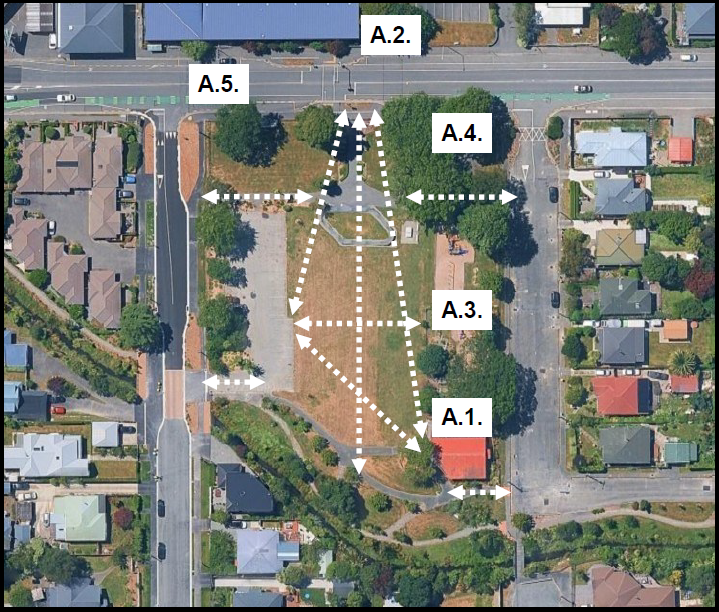
A. Existing Reserve Users
A.1. Shirley Playcentre
A.2. Shirley Primary School
A.3. Reserve Playground
A.4. Shirley Recreational Walkers
A.5. Shirley Road Bus Stops
For more details see: Page 1 of my Consultation Feedback .pdf
Consultation Feedback by Joanna Gould
A. Existing Reserve Users (White Boxes) & B. Access & Footpaths (White Lines)
B. Access & Footpaths
– B.1. Shirley Road
– B.2. Chancellor Street
– B.3. Dudley Creek
– B.4. Slater Street
For more details see: Page 1 of my Consultation Feedback .pdf
Consultation Feedback by Joanna Gould
C. Reserve Zones
C. Reserve Zones
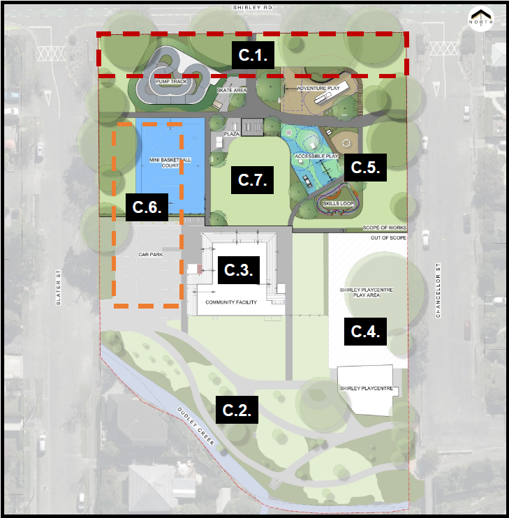
– C.1. ‘Road’ Zone (Red Dotted Line):
Currently this grass area is empty, apart from the rarely used half basketball court, located in the Reserve on the corner of Shirley Road & Chancellor Street.
This area needs to remain as a clear buffer zone, due to the amount of visual noise in front of the Reserve on Shirley Road.
Red light runners are still a problem, going through the signalized pedestrian crossing.
Road users are already visually distracted enough with the Hills/Shirley Road intersection lights, signalized pedestrian crossing lights, pedestrians waiting to cross, bus stops on both sides of Shirley Road, vehicles turning on to Shirley Road from Slater & Chancellor Streets & cycle lane users.
– C.2. ‘Creek’ Zone
– C.3. ‘Building’ Zone
– C.4. ‘Playcentre’ Zone
– C.5. ‘Playground’ Zone
– C.6. ‘Car Park’ Zone (Orange Dotted Line)
– C.7. ‘Grass’ Zone
For more details see: Page 2 of my Consultation Feedback .pdf
Consultation Feedback by Joanna Gould
D. CCC Draft Plan
D. CCC Draft Plan
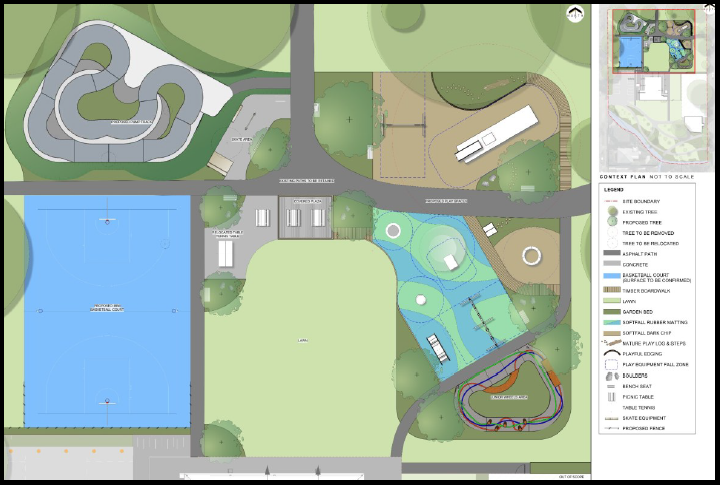
– D.1. Pump Track:
Adding a new larger pump track, closer to Shirley Road in the ‘Road’ Zone, will put road users at risk of being distracted by pump track users, with the potential to cause more accidents at this location.
Unsupervised children on scooters/bikes using the signalized pedestrian crossing, crossing from the Shirley side (North) to the Richmond side (South), could be put at risk as they ride across due to their speed/height.
– D.2. Skate Area:
As above, this location adds distraction to Shirley Road users, congestion at the entrance gate with other park users & safety issues for skateboarders crossing Shirley Road.
– D.3. Adventure Play:
As above, H: Mega Swing at this location, close to Shirley Road in the ‘Road’ Zone will be distracting.
Due to the height/width & solid state of the G: Adventure Climber structure.
No ability to see through the structure, limiting visibility of children playing on the north side from the rest of the Play area.
– D.4. Accessible Play
For more details see:
https://www.10shirleyroad.org.nz/reserve-development-plan-play-zone/
– D.5. Skills Loop
– D.6. Basketball Court
– D.7. Table Tennis Table
– D.8. Plaza Picnic Tables
For more details see: Page 3 of my Consultation Feedback .pdf
Consultation Feedback by Joanna Gould
E. ‘Shirley Centre’ Plan
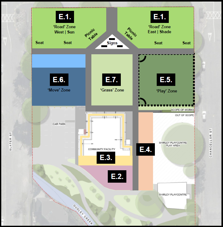
E.5. ‘Play’ Zone: Fully Fenced, Inclusive, Accessible Play Space for Children
E.6. ‘Move’ Zone: Inclusive, Accessible, Intergenerational Outdoor Fitness Space
E. ‘Shirley Centre’ Plan
This plan focuses on reinstating the ‘Community Centre’ building as the ‘primary’ purpose of the Reserve & keeping most of the Reserve as an Open Green Space.
With complementary activities to ‘enhance the well-being’ of Reserve users, by providing ‘active’ options for all ages & stages, through the:
– ‘Play’ Zone (Babies, Preschoolers, Primary Aged Children):
Fully Fenced, Inclusive, Accessible Play Space for Children &
– ‘Move’ Zone (Youth, Adults, Older Adults):
Inclusive, Accessible, Intergenerational Outdoor Fitness Space.
– E.1. ‘Road’ Zone:
Shirley Community Reserve is located on Shirley Road, between Hills & Marshland Road, which are key urban arterial routes, high-volume urban road (15,000+ per day), many non-locals going past this location.
Picnic Tables: Both sides of Shirley Road entrance with separate rubbish bins, one in sun, one in shade, visibility over the whole Reserve & easily seen from the surrounding streets.
Seating (Bench Seats & Boulders): Bench seats (with no backs) & Boulders, ability to face either direction towards Shirley Road or either the ‘Move’ & ‘Play’ zones, available in the sun or shade, safe place to wait for bus & Shirley Primary School users.
‘Road Zone’ West | Sun: Grass area with new landmark, specimen deciduous tree, seasonal foliage & berries to attract birds e.g. Cornus ‘Eddie’s White Wonder’ & fragrant/texture plants to create a calming sensory garden.
‘Road Zone’ East | Shade: Grass area with Nature Play options: boulders & repurposed Emmett Street trees/logs with Interpretation Board on the corner closest to their original home, sharing their story & our local history.
– E.2. ‘Creek’ Zone:
Pollinator Friendly Garden, designed to provide food/water/shelter for bees & attract Monarch butterflies.
– E.3. ‘Building’ Zone:
Deck extension to create wraparound deck for the building with seating area for the Reserve’s best view.
– E.4. ‘Playcentre’ Zone:
Community Garden, Shirley Playcentre & Shirley Primary School connection, with learning opportunities.
– E.5. ‘Play’ Zone (Babies, Preschoolers, Primary Aged Children):
Inclusive Play Space, designed to cater for the neurodiverse community (Feasibility Study 2023): “Opportunity to provide for inclusive play…Reserve is already currently fenced, which is rare particularly in the area north of Bealey Avenue…fenced playground…something the Disability community is advocating for more of, in particular the Autism community in Christchurch.”
More seating/safe observation locations.
Fenced area with two access gates: North/close to Shirley Road & South/close to car park/playcentre.
For more details see:
https://www.10shirleyroad.org.nz/reserve-development-plan-play-zone/
– E.6. ‘Move’ Zone (Youth, Adults, Older Adults):
Larger Blue Area: In South Korea free outdoor fitness equipment features in virtually all public parks. Open 24/7 & no membership.
Used by youth/adults/older adults for daily health maintenance & social gathering.
Equipment for low-impact stretching & mobility, plus bars for calisthenics & functional movement training.
Opportunities for circuit training/cardio along Reserve & Dudley paths/Chancellor St.
Light Blue Area: Basketball/Netball Combo, with different goal at each end, colour coded layout markings.
For more details see:
https://www.10shirleyroad.org.nz/reserve-development-plan-move-zone/
– E.7. ‘Grass’ Zone
Large Open Space for outdoor activities to complement indoor activities & opportunities to connect each Zone to the new building eg:
E.6.+E.7.+E.3. = ‘Move’ Zone combo or
E.5.+E.7.+E.3. = ‘Play’ Zone combo.
For more details see: Page 4 of my Consultation Feedback .pdf
‘Shirley Centre’ Plan | Suggestions
– https://www.10shirleyroad.org.nz/playground-ideas/
– https://www.10shirleyroad.org.nz/shirley-centre-transport/
– https://www.10shirleyroad.org.nz/local-green-spaces/
– https://www.10shirleyroad.org.nz/gateway-to-the-east/
Consultation Feedback by Joanna Gould
F. Reserve Activation
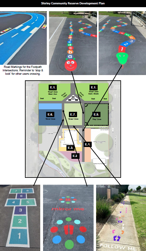
F.7. Footpath Games & Exercises
F. Reserve Activation
– F.5. Information Signs & Interpretation Board (White Triangle at Shirley Road Entrance)
Information Sign 1:
‘You Are Here’, Location Map, Reserve Building Info, Booking Info, What’s On Info.
Information Sign 2:
‘Need Help?’, Links to local Support Services (as requested by ReVision Youth Audit).
Interpretation Board:
‘Tell Our Stories’, History of Shirley Road, Original Building, Local History etc.
– F.6. StoryWalk
StoryWalk is an interactive outdoor literacy activity, where the pages of a children’s picture book are displayed on posts along a walking path, allowing families to read a story while walking through nature.
‘The Wonderful Stranges’ by Melanie Koster (Christchurch Author):
https://christchurch.bibliocommons.com/v2/record/S37C1567292
– F.7. Footpath Games & Exercises
Turn ordinary footpaths into active/engaging/movement paths, good for all ages & abilities. Also useful to redirect young children who need distracting when transitioning from the E.5. ‘Play’ Zone to leave the Reserve & go home, plus moving from the car park to go to the playcentre or school.