
1. Waipapa Papanui-Innes-Central Community Board Meeting (9th Nov 2026)
2. Shirley Community Reserve – Landscape Development Plan (CCC Staff Report)
3. Shirley Community Reserve Development Plan (Consultation Feedback)
4. Shirley Community Reserve Development Plan (Feedback Summary)
5. CCC Staff Report & ‘Final Landscape Plan’ (My Feedback)
– 5.1. Location Map & Safety Issues
– 5.2. Reserve Classification & History
– 5.3. Access, Visibility & Wayfinding
– 5.4. Activities & Funding
– 5.5. Reserve & Play Space Fencing
1. Waipapa Papanui-Innes-Central Community Board Meeting (9th Nov 2026)
https://christchurch.infocouncil.biz/Open/2026/11/PCBCC_20261109_AGN_11318_AT_WEB.htm
Item 7. Shirley Community Reserve – Landscape Development Plan
2. Shirley Community Reserve – Landscape Development Plan (CCC Staff Report)
“3.5 Following consideration of submissions, several amendments were made to the draft plan, including changes to the skate area, play equipment and fencing arrangements. Requests for additional facilities and environmental initiatives that sit outside the project scope have been considered and responded to within this report.”
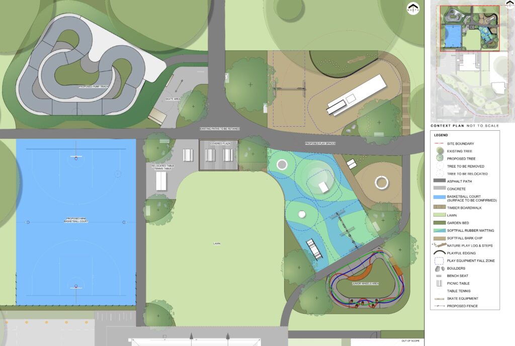
Landscape Development Plan
Draft | Version 1 | Prior to Consultation
(The wrong image is included in the CCC Staff Report.
4.9, Figure 1 shows the Final, Version 2 plan)
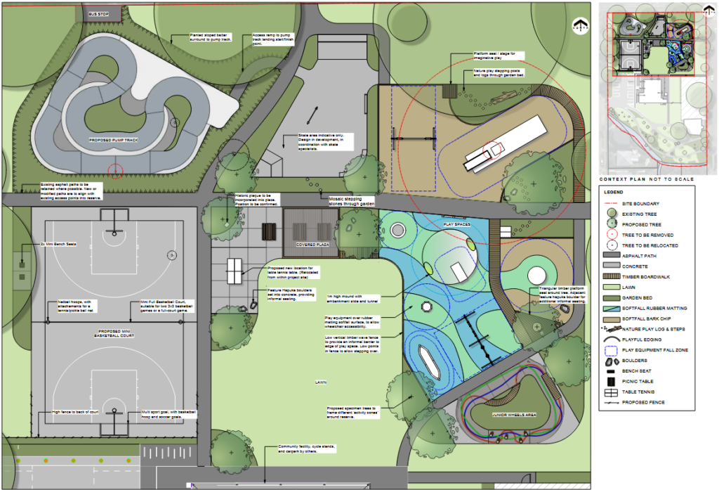
Landscape Development Plan
Final | Version 2 | After the Consultation
3. Shirley Community Reserve Development Plan (Consultation Feedback)
While the ‘Early Feedback’ from our three local schools is included in the CCC Staff Report as ‘Attachments’.
The ‘Let’s Talk’ Consultation Submissions are not included as an ‘Attachment’ in the CCC Staff Report, to help inform elected members with their decision making.
‘Summary of Submissions Ngā Tāpaetanga’
7.24 Submissions were made by five recognised organisations and 20 individuals.
All submissions are available on our Kōrero mai webpage.
7.28 A wide range of comments were received that can be read in the submission document.
‘Let’s Talk’ Shirley Community Reserve Development Plan:
https://letstalk.ccc.govt.nz/SCRdevelopmentplan/agenda-available
‘Decision-making documents’:
Shirley Community Reserve landscape plan – submissions (Link):
https://hdp-au-prod-app-ccc-letstalk-files.s3.ap-southeast-2.amazonaws.com/9617/8968/1777/Shirley_Community_Reserve_development_plan_-submission_document-_public.pdf
My submission is included on Pages 37-45.
I also emailed CCC Staff the following blog posts (updated/expanded submission):
– Reserve Development Plan Feedback
– Reserve Development Plan ‘Play’ Zone
– Reserve Development Plan ‘Move’ Zone
– MacFarlane Park South Play Space &
– Shirley Community Reserve Activation
9. Shirley Library | Current Activities
10. Activities available at other Christchurch Suburban Libraries &
11. Other Potential Reserve Users.
Plus I wrote this post on my ‘Shirley Centre 10 Shirley Road’ Facebook Page:
https://www.facebook.com/share/p/1C3uvkhiQJ/
(See Comments/Links)
The Waipapa Papanui-Innes-Central Community Board’s vision is for the:
“Shirley Community Reserve to become:
– a destination of choice for the community,
– a safe space,
– a place that enhances well-being, and
– provides a place for social connection.”
1. How can the Reserve be developed to invite more residents to ‘come, stay & play’?
2. What areas can be included to create a ‘safe, inclusive, intergenerational space’?
3. How can the Reserve be used to ‘enhance the well-being’ for all ages & stages of life?
4. Where are the opportunities for ‘passive’ (to be) & ‘active’ (to do) Reserve users?
4. Shirley Community Reserve Development Plan (Feedback Summary)
7.16 Early feedback sessions were held between December 2025 and June 2026 with Pareawa Banks Avenue Primary School, Te Hiwa Shirley Primary School and Te Oraka Shirley Intermediate School.
– ‘Dudley Creek’ theme
– natural materials and colours
– inclusive play space for all ages
– retaining the perimeter fence
– places for adults to sit and gather
7.25 Avon Ōtakaro Network Inc and Food Resilience Network Inc were concerned the plan over-emphasised infrastructure and didn’t do enough to improve ecological and environmental outcomes.
Ōtautahi Skate Association requested changes to the skate area.
7.27 Four submitters thought the skate area needed amending, three did not like the greenspace reduction.
7.31 Support for the lawn area near the community facility.
The skills loop area including road safety learning opportunities.
Interest in native planting and labels identifying trees in the reserve.
Increased security in the reserve, including amending the play whare to make sure rough sleepers cannot use it.
More Māori imagery and design throughout the play space.
5. CCC Staff Report & ‘Final Landscape Plan’ (My Feedback)
Below is my feedback regarding the CCC Staff Report & ‘Final Landscape Plan’:
– 5.1. Location Map & Safety Issues
The Landscape Plan has been designed in isolation within the Reserve, without considering the safety issues on Shirley Road.
https://smartview.ccc.govt.nz/data/road-crashes
Before I started advocating for 10 Shirley Road in 2018, I was advocating for the safety issues outside Shirley Primary School, asking the Council/Community Board in 2017 to address these issues.
https://www.10shirleyroad.org.nz/traffic-issues-outside-shirley-primary-email/
In the ‘Location Map’ below, I’ve highlighted the ‘Road’ Zone (Red Dotted Line).
This area needs to remain as a clear buffer zone, due to the amount of visual noise in front of the Reserve on Shirley Road.
Shirley Community Reserve is located between Hills & Marshland Road, which are key urban arterial routes, high-volume urban road (15,000+ per day), with many non-locals going past this location each day.
The four activities (Pump Track, Skate Area, Mega Swing, Adventure Climber) will involve young children making sudden & unpredictable movements, as they explore these activities.
Young children running between activities at the front of the Reserve, falling down & accidents will occur as they use these activities, adding visual noise/distractions for all road & footpath users.
Passengers seeing these activities may draw the attention of driver, away from the obstacles on the road/cycle lane/footpath.
These four activities would be best suited in MacFarlane Park South (off Jebson Street) behind the Shirley Primary School, as a new family friendly destination space, away from a busy main road, yet still easily accessible off Hills/Shirley Road.
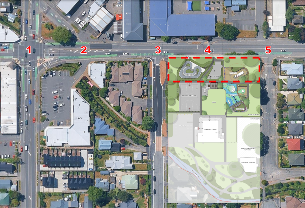
Location Map (Hills & Shirley Road)
with CCC Staff ‘Final Landscape Plan’ Insert
The ‘Red’ numbers from 1 – 5, are highlighted for these reasons:
– ‘Red’ 1. Hills/Shirley Road Intersection: known safety issues/crashes, raised ‘Speed Hump Platform’ stop/start movements to get over/down the platform, red light runners turning right from Hills Road onto Shirley Road.
– ‘Red’ 2. Traffic splits into four directions: turning into/exiting the Shirley Shopping Centre car park, going straight, turning right & give way turning left with pedestrian crossing.
Give Way from Hills Road, turning left onto Shirley Road (North of No. 2).
Entrance/Exit from Shirley Shopping Centre car park (South of No. 2).
– ‘Red’ 3. Slater Street/Shirley Road Intersection: Buses pulling in/out both sides of the road.
Pedestrians & other footpath users waiting/crossing the street.
Shirley Road users waiting to turn right onto Slater Street, to access the Reserve car park & go to the new Community Centre building.
Slater Street users turning left/right onto Shirley Road, with cycle lanes/bus stop.
Shirley Road users turning left into Slater Street, with cycle lanes/bus stop.
– ‘Red’ 4. Signalised Pedestrian Crossing: Red light runners, distracted by the existing visual noise (two sets of lights close together) & different ages/mobility levels/transport modes all in one space.
Short term street parking on both sides of the road.
Bottleneck on footpaths either side of Shirley Road at peak times, with entrance/exit to Shirley Primary School (North) & Shirley Community Reserve (South).
– ‘Red’ 5. Chancellor Street/Shirley Road Intersection: Shirley Primary School Staff car park entrance/exit (North of No. 5).
Pedestrians & other footpath users waiting/crossing the street.
Shirley Road users waiting to turn right onto Chancellor Street, with cycle lanes.
Chancellor Street users turning left/right onto Shirley Road, with cycle lanes.
– 5.2. Reserve Classification & History
The 10 Shirley Road site has been a ‘place of learning’ since 1915.
In 1980, this site became the Shirley Community Reserve, a ‘Local Purpose’ reserve (site for a community centre).
This differs from a ‘Recreation’ reserve, like the MacFarlane Park in Shirley.
“the classification reflects the primary purpose of the reserve, but that does not prevent other compatible activities occurring there.
It is also possible to classify part of a reserve for one purpose and the other part or parts of the same reserve for any other purpose, but that would require a survey to define the separate parts.”
https://www.10shirleyroad.org.nz/email-to-the-department-of-conservation-17th-sept-2025/
The CCC Staff ‘Final Landscape Plan’ is generic, it could be located in any suburb in Christchurch.
After the Canterbury Earthquakes, we lost our homes, schools, churches, community facilities, local landmarks…
Now with the changes to the Christchurch District Plan, our standalone family homes with big backyards & garages are being demolished, to be replaced with multiple townhouses on the same site, with a small outdoor space & many without garages.
The ‘Shirley Centre’ plan focuses on reinstating the ‘Community Centre’ building as the ‘primary’ purpose of the Reserve & keeping most of the Reserve as an Open Green Space, for all the residents in our communities to enjoy.
With “porous surfacing to allow water to drain away” for the ‘Play’ & ‘Move’ Zones.
Not by adding more concrete/asphalt, as in the CCC Staff ‘Final Landscape Plan’.
We can continue to honor this site as a ‘place of learning’, by connecting indoor & outdoor spaces, through activating the Reserve with different learning opportunities.
With complementary activities to ‘enhance the well-being’ of Reserve users, by providing ‘active’ options for all ages & stages, through the:
– ‘Play’ Zone (Babies, Preschoolers, Primary Aged Children):
Fully Fenced, Inclusive, Accessible Play Space for Children &
– ‘Move’ Zone (Youth, Adults, Older Adults):
Inclusive, Accessible, Intergenerational Outdoor Fitness Space.
‘Tell Our Stories’
4.29 Staff also received a request to incorporate some of the building material from the former community centre either in the new built or in the wider park.
As this request could not be accommodated in the new community centre built, staff have allowed for the inclusion of a historic plaque within the plaza space.
Foundation Stone and Foundation Deposit from the original building:
https://www.10shirleyroad.org.nz/wp-content/uploads/2025/04/ShirleyCommunityCentreBuildingRetrievals.pdf
Last year I was able to finally find more information & photos of the original building, including the original blueprints & hand drawn watercoloured plans by George Penlington, from 1915.
Where are the details that ‘Tell Our Stories’ of our communities identity?
– History of the Land
– Original Shirley Road
– Original Shirley School
– George Penlington
– George Brington Malcolm
– Social Housing History
– Chancellor Street Heritage Houses
– Dudley Creek
– Dudley Character Area
– Shirley Community Centre
– Canterbury Earthquakes
– Dudley Creek Flood Remediation
– Shirley Community Centre Rebuild
– 5.3. Access, Visibility & Wayfinding
4.33 Crime Prevention Through Environmental Design (CPTED) principles have been considered in determining the overall layout and arrangement of the various activities, with a focus on increasing passive surveillance through proximity to the road and the new Community Centre.
4.36 The Final Landscape Plan for Shirley Community Reserves maintains some of the existing paths but also forms new path connections to provide greater access throughout the reserve.
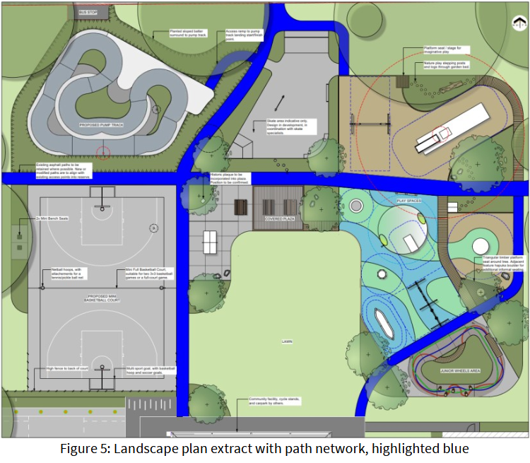
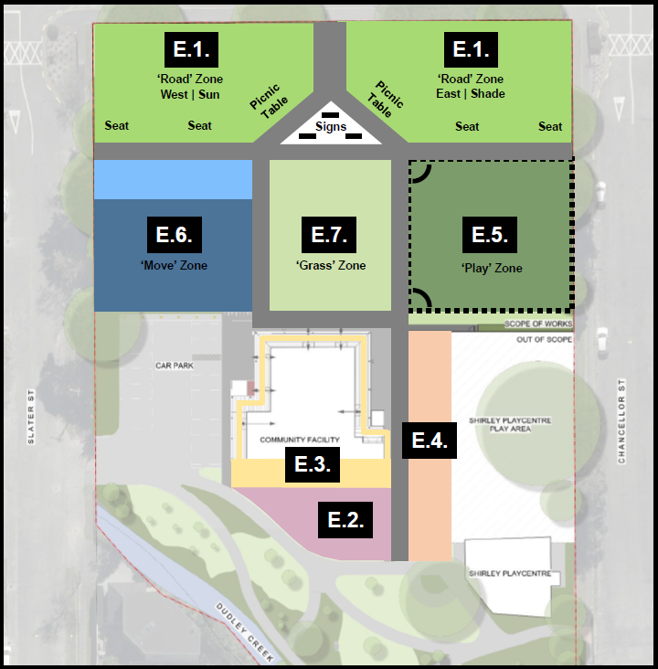
Consultation Feedback by Joanna Gould
https://www.10shirleyroad.org.nz/reserve-development-plan-feedback/
‘Shirley Centre’ Plan
E.5. ‘Play’ Zone: Fully Fenced, Inclusive, Accessible Play Space for Children
E.6. ‘Move’ Zone: Inclusive, Accessible, Intergenerational Outdoor Fitness Space
The Shirley Road entrance gate/footpath into the Reserve is a bottleneck at drop off/pickup times.
Pedestrians crossing from Shirley Road trying to get into the Reserve, have to push past those waiting on the Reserve side to cross at the signalized pedestrian crossing.
Reducing the path width at this location is going to cause more problems & stress during peak times.
Proposing a Pump Track on one side of the main path, with a Skate Area on the other side, will require all Reserve users to get past this obstacle course.
It will be off putting for many potential users of the new Community Centre building.
My ‘Shirley Centre’ plan above, shows a wider path that splits into two paths to allow Reserve users different options, to make it easier to get where they need to go.
West Path: ‘Move’ Zone, Car Park, Community Centre building & access to Dudley Creek.
East Path: ‘Play’ Zone, Shirley Playcentre users, Community Centre building & access to Dudley Creek.
Footpaths: Wider than normal, easy to navigate, simple direct access from A to B.
Timber Boardwalks: Accessibility & safety issues due to slick surfaces for wheelchairs, mobility scooters & strollers.
– ‘F.5. Information Signs & Interpretation Board’ from my ‘Shirley Centre’ plan:
(White Triangle at Shirley Road Entrance)
Information Sign 1:
‘You Are Here’, Location Map, Reserve Building Info, Booking Info, What’s On Info.
Information Sign 2:
‘Need Help?’, Links to local Support Services (as requested by ReVision Youth Audit).
Interpretation Board:
‘Tell Our Stories’, History of Shirley Road, Original Building, Local History etc.
(This was requested by the Board in 2022, as suggested by the ‘Shirley Road Central’ residents group, that I was a part of.
“4.24 After discussion with representatives from the Shirley Road Central group it was agreed the Visitor Experience Team would also investigate developing one or two interpretation boards.
These would tell the stories of both local and city-wide significance; original school heritage buildings, community centre and its role in the community, historic domestic buildings adjacent to the park, and Dudley Creek remediation.
The Shirley Road Central group has provided reference material.”)
https://www.10shirleyroad.org.nz/shirley-community-reserve-memo/
– ‘F.6. StoryWalk’ from my ‘Shirley Centre’ plan:
StoryWalk is an interactive outdoor literacy activity, where the pages of a children’s picture book are displayed on posts along a walking path, allowing families to read a story while walking through nature.
‘The Wonderful Stranges’ by Melanie Koster (Christchurch Author):
https://christchurch.bibliocommons.com/v2/record/S37C1567292
– ‘F.7. Footpath Games & Exercises’ from my ‘Shirley Centre’ plan:
Turn ordinary footpaths into active/engaging/movement paths, good for all ages & abilities. Also useful to redirect young children who need distracting when transitioning from the E.5. ‘Play’ Zone to leave the Reserve & go home, plus moving from the car park to go to the playcentre or school.
– 5.4. Activities & Funding
Q.1. Who will use the Reserve Outdoor Spaces the most?
People who are not in school or at work, during the day.
Preschoolers, Youth, Adults, Older Adults.
Q.2. What age group does the CCC Staff ‘Final Landscape Plan’ cater for through activities?
Primary/Intermediate school aged children, who already have access to their own school playgrounds.
The current playground caters to preschoolers, better than the proposed play space.
While Youth/Adults/Older Adults can either sit on a seat or the grass?
Q.3. How many different activities are included in the CCC Staff ‘Final Landscape Plan’?
Seven activities.
Basketball Court, Pump Track, Skate Area, Mega Swing, Adventure Climber, Accessible Play Space & Skills Loop.
In my ‘Shirley Centre’ plan there are two activity areas: ‘Play’ & ‘Move’ Zones.
Q.4. Given the limited budget, is it ‘value for money’ for the Board to invest in a few activities or more?
The proposed Basketball Court covers a large part of the Reserve.
Is it a waste of resources if only one person is shooting hoops, when there are already these ‘Recreation’ facilities available, at Avon Hub (other end of Shirley Road) & MacFarlane Park?
https://www.10shirleyroad.org.nz/shirley-centre-community-overview-map/
The ‘Pump Track, Skate Area, Mega Swing, Skills Loop’ activities have a limited number of participants, who can safely use these activities at the same time.
While the ‘Play’ & ‘Move’ Zones in my ‘Shirley Centre’ plan, allow many participants to engage in these spaces at the same time, creating more opportunities for social connections.
https://www.10shirleyroad.org.nz/local-green-spaces/
Q.5. If residents want a ‘Pump Track, Skate Area, Mega Swing, Adventure Climber, Skills Loop & the Table Tennis Table’ in MacFarlane Park South, how can the Board fund this?
By securing funding for the development of the ‘MacFarlane Park South Play Space’ & ‘MacFarlane Park Community Garden Extension’, in the Long Term Plan next year.
Other funding partners: Department of Internal Affairs, Kāinga Ora & Rātā Foundation.
https://www.10shirleyroad.org.nz/macfarlane-park-south-play-space/
– 5.5. Reserve & Play Space Fencing
4.41 The area, identified by the orange line in Figure 6 [below] is the existing fencing. The proposed additional fencing is highlighted by the green lines. The Community Centre building (shown in blue) will form part of the enclosure; however, a small opening will remain between the basketball court and the south-western corner of the building, highlighted by red line.
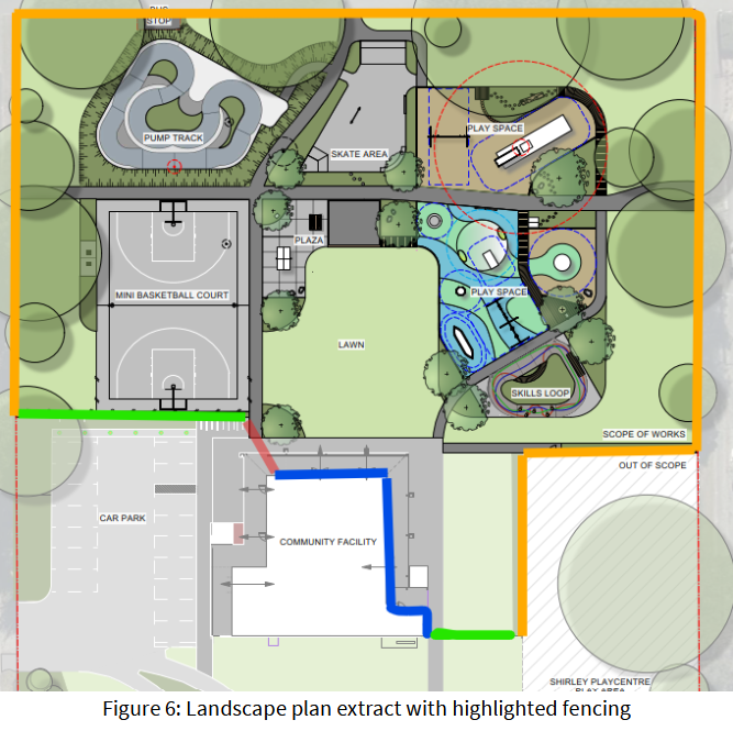
Feasibility Study 2023: “Opportunity to provide for inclusive play…Reserve is already currently fenced, which is rare particularly in the area north of Bealey Avenue…fenced playground…something the Disability community is advocating for more of, in particular the Autism community in Christchurch.”
Equity: Equality means each individual or group of people is given the same resources or opportunities.
Equity recognises that each person has different circumstances and allocates the exact resources and opportunities needed to reach an equal outcome.
People should have equity, regardless of age, gender, disability, ethnicity, culture, faiths, geographical location, sexual orientation, neurodiversity or socio-economic status.
https://www.10shirleyroad.org.nz/ccc-equity-and-inclusion-policy/
A fully fenced play space is needed plus the perimeter fencing, to add two barriers between the busy Shirley Road & protect young children from dogs on the Reserve.
This will create a safe space for the Autism community in Christchurch & for families/parents/caregivers supervising more than one child playing at the Reserve.